Difference between revisions of "2008-12-15 53 9"
imported>Hermann (New page: {{meetup graticule | map=<map lat="53" lon="9" date="2008-12-15" /> | lat=53 | lon=9 | date=2008-12-15 }} ==About== *Coordinates: 53.668823116373005 9.555277513533678 *Surroundings: the r...) |
imported>Hermann |
||
| Line 8: | Line 8: | ||
==About== | ==About== | ||
*Coordinates: 53.668823116373005 9.555277513533678 | *Coordinates: 53.668823116373005 9.555277513533678 | ||
| − | *Surroundings: the river Elbe, the | + | *Surroundings: the river Elbe, the dike, grazing land |
*Weather: cold, dry winter night | *Weather: cold, dry winter night | ||
| − | The hash is located on the | + | The hash is located on the dike near the "Pinnau" flood barrage. |
==Expedition== | ==Expedition== | ||
'''[[User:Hermann|Hermann]]''' and [[User:Felix|Felix]] dragged Matthias and Cornelius along:<br> | '''[[User:Hermann|Hermann]]''' and [[User:Felix|Felix]] dragged Matthias and Cornelius along:<br> | ||
| − | After playing a [http://www.getdota.com DotA] | + | After playing a [http://www.getdota.com DotA] we decided to drive to this hash. By car. Normally I try to reach hashes in range by bike, but it was a) cold and b) dark. Luckily I got Felix, Matthias and Cornelius to accompany me (and making this a [[Drag-Along Geohash]]). |
| − | First off, I collected Felix, Cornelius and Matthias and headed for the spot. Unfortunately the three were at issue how to operate | + | |
| − | On the | + | First off, I collected Felix, Cornelius and Matthias and headed for the spot. Unfortunately the three were at issue how to operate my mobile navigation device, so we took a rather strange route to the village "Kreuzdeich" and got out of the car although we could have driven closer to the spot. |
| + | |||
| + | On the dike we tried to avoid the sheeps' droppings. We planned to have a lebkuchen but as soon as I gave it to Cornelius, it was gone. We spend some time running round in circles trying to decide which of our three GPS-devices was most inaccurate: A cheap PNA from "Aldi", a mobile's built-in GPS-receiver or a home-made GPS-tracker with binary readings. Having his brain frozen down to a critical temperature, Matthias converted the second-split-reading of his mobile into the decimal notation in his mind, when we decided that we were close enough to take the photo. | ||
| + | |||
| + | On the way back we noticed a big red blotch on the road. <br> Which was paint. | ||
| + | |||
| + | I hope. | ||
<gallery caption="Pictures" widths="200px" heights="200px" perrow="3"> | <gallery caption="Pictures" widths="200px" heights="200px" perrow="3"> | ||
| + | Image:Hermann_Geohash_2008-12-15_53_9_PC156444.JPG | At the dike | ||
| + | Image:Hermann_Geohash_2008-12-15_53_9_PC156447.JPG | On the hash | ||
| + | Image:Hermann_Geohash_2008-12-15_53_9_PC156448.JPG | Coordinates | ||
</gallery> | </gallery> | ||
| + | [[Image:Hermann_Geohash_2008-12-15_53_9_PC156449.JPG|frame|The city Stade]] | ||
[[Category:Expeditions]] | [[Category:Expeditions]] | ||
[[Category:Expeditions with photos]] | [[Category:Expeditions with photos]] | ||
[[Category:Coordinates reached]] | [[Category:Coordinates reached]] | ||
Revision as of 13:48, 16 December 2008
| Mon 15 Dec 2008 in 53,9: 53.6688231, 9.5552775 geohashing.info google osm bing/os kml crox |
About
- Coordinates: 53.668823116373005 9.555277513533678
- Surroundings: the river Elbe, the dike, grazing land
- Weather: cold, dry winter night
The hash is located on the dike near the "Pinnau" flood barrage.
Expedition
Hermann and Felix dragged Matthias and Cornelius along:
After playing a DotA we decided to drive to this hash. By car. Normally I try to reach hashes in range by bike, but it was a) cold and b) dark. Luckily I got Felix, Matthias and Cornelius to accompany me (and making this a Drag-Along Geohash).
First off, I collected Felix, Cornelius and Matthias and headed for the spot. Unfortunately the three were at issue how to operate my mobile navigation device, so we took a rather strange route to the village "Kreuzdeich" and got out of the car although we could have driven closer to the spot.
On the dike we tried to avoid the sheeps' droppings. We planned to have a lebkuchen but as soon as I gave it to Cornelius, it was gone. We spend some time running round in circles trying to decide which of our three GPS-devices was most inaccurate: A cheap PNA from "Aldi", a mobile's built-in GPS-receiver or a home-made GPS-tracker with binary readings. Having his brain frozen down to a critical temperature, Matthias converted the second-split-reading of his mobile into the decimal notation in his mind, when we decided that we were close enough to take the photo.
On the way back we noticed a big red blotch on the road.
Which was paint.
I hope.
- Pictures
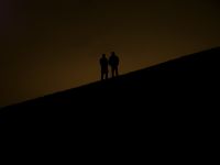
At the dike
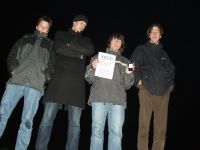
On the hash
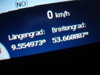
Coordinates


