2008-12-20 32 -111
| Sat 20 Dec 2008 in Casa Grande: 32.0138231, -111.3421750 geohashing.info google osm bing/os kml crox |
Participants
Expeditions
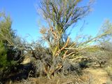
First geohash attempt. It was 15 miles away and looked to be 1/2 mile off the paved road. I didn't load detailed topo maps since I figured it would be a simple hike into the desert. When we got close, we found a dirt road that headed toward the spot. Turns out it was an abandon housing development that had graded off the roads at one time. We ended up parking in a future cul-de-sac and hiking about 300 yards to the location, arriving at 4:00pm on the dot. Took a picture of an unusual palo verde tree, hung out and enjoyed the area for 10 minutes and headed out. Did some exploring of the unfinished, unpaved roadways and found out we could have driven within 10 feet of the geohash location. Guess thats just being kind to the new hashers. We laughed about it for quite a while as we looked at the back side of the same strange tree.
Casa Grande, Arizona
