Difference between revisions of "2009-01-01 30 -81"
imported>Woodveil |
imported>Woodveil |
||
| Line 10: | Line 10: | ||
==Expeditions== | ==Expeditions== | ||
| − | This was our first attempted geohash and it was successful. My brother and I decided to go for it the night before, and so we set out around 8:00 in the morning. Getting to the location involved exploring the north westside, near Pritchard Road. The final leg was driving about three quarters of a mile down an ostensibly-private dirt road, followed by a few hundred feet on foot. Thankfully there was a trail. The location itself was a few yards away from some railroad tracks, and we used them in conjunction with a treeline and Google maps to find the spot as best we could. We took some pictures, picked up some trash and a Geotrash ribbon, wrote "xkcd" in the dirt, and left. | + | This was our ([[User:Woodveil|Woodveil]]) first attempted geohash and it was successful. My brother and I decided to go for it the night before, and so we set out around 8:00 in the morning. Getting to the location involved exploring the north westside, near Pritchard Road. The final leg was driving about three quarters of a mile down an ostensibly-private dirt road, followed by a few hundred feet on foot. Thankfully there was a trail. The location itself was a few yards away from some railroad tracks, and we used them in conjunction with a treeline and Google maps to find the spot as best we could. We took some pictures, picked up some trash and a Geotrash ribbon, wrote "xkcd" in the dirt, and left. |
[[Category:Expeditions]] | [[Category:Expeditions]] | ||
| Line 19: | Line 19: | ||
<gallery caption="Photo Gallery" widths="200px" heights="200px" perrow="2"> | <gallery caption="Photo Gallery" widths="200px" heights="200px" perrow="2"> | ||
Image:Dirt road.jpg|Closing in on the hashpoint. | Image:Dirt road.jpg|Closing in on the hashpoint. | ||
| − | Image:Made_it!.jpg| | + | Image:Made_it!.jpg|Chris standing somewhere near it. |
Image:RR and culvert.jpg|This is looking south at the railroad tracks. Apparently someone's building a new road. | Image:RR and culvert.jpg|This is looking south at the railroad tracks. Apparently someone's building a new road. | ||
Image:Google Map.jpg|The map used, for lack of a GPS unit. | Image:Google Map.jpg|The map used, for lack of a GPS unit. | ||
Revision as of 19:54, 1 January 2009
| Thu 1 Jan 2009 in Jacksonville: 30.3784381, -81.8331568 geohashing.info google osm bing/os kml crox |
Expeditions
This was our (Woodveil) first attempted geohash and it was successful. My brother and I decided to go for it the night before, and so we set out around 8:00 in the morning. Getting to the location involved exploring the north westside, near Pritchard Road. The final leg was driving about three quarters of a mile down an ostensibly-private dirt road, followed by a few hundred feet on foot. Thankfully there was a trail. The location itself was a few yards away from some railroad tracks, and we used them in conjunction with a treeline and Google maps to find the spot as best we could. We took some pictures, picked up some trash and a Geotrash ribbon, wrote "xkcd" in the dirt, and left. [[Category:Coordinates reached]
Gallery
- Photo Gallery
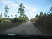
Closing in on the hashpoint.
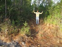
Chris standing somewhere near it.
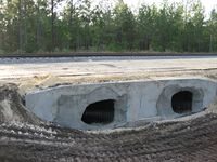
This is looking south at the railroad tracks. Apparently someone's building a new road.
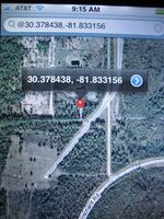
The map used, for lack of a GPS unit.
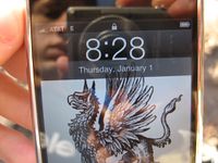
Point was reached just prior to 8:28 A.M., Thursday January 1.
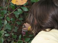
Earning my Geotrash Achievement.


Achievements
This user earned the Land geohash achievement
|
This user earned the GeoTrash Geohash Achievement
|