2009-01-01 36 -75
| Thu 1 Jan 2009 in 36,-75: 36.3784381, -75.8331568 geohashing.info google osm bing/os kml crox |
Contents
Report
When we first checked the 2009-01-01 coordinates at 15:51 UTC on Wednesday, we found a great spot in the middle of a residential road in the city of Raleigh, North Carolina. We then decided on a midnight geohash with an attempt at the Speed Racer Achievement, middle of the street formal attire, and a couple of chalk outlines. So, with all the planning completed by lunch time, we felt confident that we would add another geohash to our list. But, we were flabbergasted to find a totally new coordinate for all locations when we happened to check the website one last time at 19:21 UTC (thank God I am a bit retentive). After combing Google Earth and Garmin Topo for an hour trying to find a nearby geohash that was achievable, we were exasperated – all the hashes were either someone’s back yard or 1 mile into the woods – simply impossible for a midnight attempt in a few hours. In desperation, we cast a wider net all the way to the coast and stumbled upon the Virginia Beach, Virginia Graticule, which is mostly ocean. To our utter disbelief, the geohash for New Year’s Day landed on a narrow strip of land, not even a kilometer wide, in the Atlantic Ocean – the North Carolina Outer Banks. Even more amazingly amazing, Google Earth and Google Maps street-view seemed to indicate the geohash lay in a vacant lot, which is simply miraculous in the otherwise crowded beach resort. Are we dreaming this? A geohash at the beach?!!...a sunrise geohash on the first day of the New Year?!! OK, we go to bed at 8:00pm, wake at 2:00am, and drive the 4-1/2 hours to make the 7:24am sunrise. Our rendezvous with the ultimate New Year’s geohash awaited. After an uneventful drive to the Outer Banks, we made our way north to Corolla, past the Currituck Lighthouse, and then past an old school house, now a museum, with its yard dotted with colorfully painted cutout horses. We parked at an antique shop and stealthfully exited our vehicle, lest we arouse the ire of Corolla’s slumbering residents. We thankfully found the lot still vacant and, therefore, the entry point to our fated geohash unobstructed. With the early-morning sky turning purplish, we made our way towards the swamp bordering the Currituck Sound. Being winter, we stood a better chance navigating the maze of Raptor traps (briars), and the -0.8C temperature meant the swamp would be either frozen or cold enough to freeze the dress shoes onto our feet. So, attired in our Sunday best, we fought our way through the brush to the fated rendezvous, spooking a large White-tailed buck who trotted away in a snort (or was it one of the wild horses? – too dark to tell). Then…success! Oh what sweet victory. From the last minute planning, questionable satellite and photographic intelligence, 21st technology welded by a partially evolved Cro-Magnon man, and simple stupid luck, we achieved the geohash of a life time. After photographically recording our achievement, we hurried to the beach to make the sunrise and kiss the dawn of a new year.
Participants
Eisen & Bear - NCBears
Geological Features
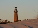
NC Outerbanks at Corolla. Sand dunes and beach on Atlantic side with swampy areas facing Currituck Sound. Geohash was in frozen marsh area behind vacant lot in the Corolla township, 0.3 km NW from the Currituck Beach Lighthouse. Location was amongst cedars, virginia creeper, and Raptor traps (briars).
Wildlife Encounters
Whitetail deer, weasle, domestic cats, goat, horse, sparrows, Harrier hawk, Seagulls, Blue Herron, and Swan. As we approached the Geohash, we scared either a large Whitetailed buck or one of the many wild horses that live in the area.
Weather
Low 30.6°F/-0.8°C, clear skies, 10-20mph/16-32kph wind
Achievements


Pictures
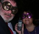
All dressed up for the New Year!
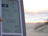
It was cold in the swamp and on the beach.
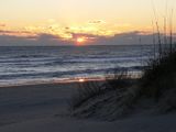
Beautiful sunrise at the beach, 0.8 km from the Geohash.
From the beach.
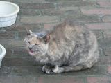
Geokitty at Lighthouse.
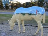
Geohorsey
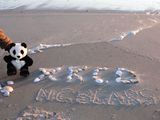
Hello XKCD from Corolla beach.


