Difference between revisions of "2009-01-02 -36 147"
imported>Kieran |
m (per Renaming Proposal) |
||
| (7 intermediate revisions by 4 users not shown) | |||
| Line 6: | Line 6: | ||
}} | }} | ||
| − | + | Today's location fell off the shore of Lake Hume, an artificial dam build 50 years ago. | |
| − | + | I should have missed out on the chance to do a water geohash. In the recent decade or so of "dryness" (as we're now told to call it), the lake has rarely been more than 30% full. But we had a bit of rain recently. | |
| + | |||
| + | For me at least, this hash was pure awesomeness. | ||
| + | |||
| + | {{Graticule unlocked | latitude = -36 | longitude = 147 | date = 2009-01-02 | name = [[user:kieran|Kieran]] | image = kieran.jpg }} {{water geohash | latitude = -36 | longitude = 147 | date = 2009-01-02 | name = [[user:kieran|Kieran]] | image = kieran.jpg | vehicle = swimming }} | ||
| + | |||
| + | <gallery> | ||
| + | Image:2ramp 2009-01-02 -36-146.jpg|With low water levels during the current drought, the boat ramp is a bit redundant. | ||
| + | Image:1footings 2009-01-02 -36-146.jpg|The footings of one of many buildings drowned during the building of the Hume Dam | ||
| + | Image:3stump 2009-01-02 -36-146.jpg|One of many drowned trees, now exposed. The soil washed away from the roots... | ||
| + | Image:4pelicans 2009-01-02 -36-146.jpg|We saw pelicans, an eagle, hares, and various water birds. | ||
| + | Image:5wilson 2009-01-02 -36-146.jpg|Along the way, we found treasure. I named him Wilson. | ||
| + | Image:6trees 2009-01-02 -36-146.jpg|More drowned trees, with the soil eroded around them. | ||
| + | Image:7gps 2009-01-02 -36-146.jpg|Right longitude, but the latitude was pointing me out into the lake | ||
| + | Image:8swimming 2009-01-02 -36-146.jpg|So bracing the cold I headed into the lake | ||
| + | Image:9geohash 2009-01-02 -36-146.jpg|And then much further into the lake (I'm the dot just before the trees) | ||
| + | Image:10underwater 2009-01-02 -36-146.jpg|Back on dry land, but the GPS thought I was still well and truly under water! | ||
| + | </gallery> | ||
| + | |||
| + | [[Category:Meetup on 2009-01-02]] [[Category:Meetup in -36 147]] | ||
| + | [[Category:Coordinates reached]] [[Category:Expeditions with photos]] [[Category:Expeditions]] | ||
| + | {{location|AU|VIC|IN}} | ||
Latest revision as of 06:39, 20 March 2024
| Fri 2 Jan 2009 in -36,147: -36.1995170, 147.0589406 geohashing.info google osm bing/os kml crox |
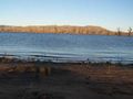
Today's location fell off the shore of Lake Hume, an artificial dam build 50 years ago.
I should have missed out on the chance to do a water geohash. In the recent decade or so of "dryness" (as we're now told to call it), the lake has rarely been more than 30% full. But we had a bit of rain recently.
For me at least, this hash was pure awesomeness.
Kieran earned the Graticule Unlocked Achievement
|
Kieran earned the Water geohash achievement
|
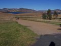
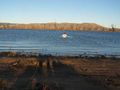
With low water levels during the current drought, the boat ramp is a bit redundant.
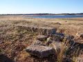
The footings of one of many buildings drowned during the building of the Hume Dam
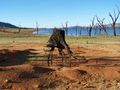
One of many drowned trees, now exposed. The soil washed away from the roots...
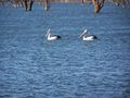
We saw pelicans, an eagle, hares, and various water birds.
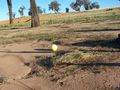
Along the way, we found treasure. I named him Wilson.
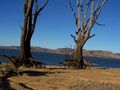
More drowned trees, with the soil eroded around them.
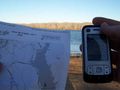
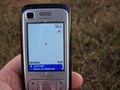
Right longitude, but the latitude was pointing me out into the lake
So bracing the cold I headed into the lake
And then much further into the lake (I'm the dot just before the trees)
Back on dry land, but the GPS thought I was still well and truly under water!


