Difference between revisions of "2009-01-12 48 12"
imported>Thomcat m |
imported>FippeBot m (Location) |
||
| (2 intermediate revisions by one other user not shown) | |||
| Line 1: | Line 1: | ||
| − | |||
| − | |||
| − | |||
{{meetup graticule | {{meetup graticule | ||
| map=<map lat="48" lon="12" date="2009-01-12"/> | | map=<map lat="48" lon="12" date="2009-01-12"/> | ||
| Line 11: | Line 8: | ||
}} | }} | ||
| − | + | In a frozen, snowy field south of Neutraubling, about 10km southeast of Regensburg. Just 400m northeast of [[2008-12-18 48 12]]. Dawidi and Tomcat were there independently and did not meet. | |
| + | |||
| + | == Morning visit ([[User:Dawidi|dawidi]]) == | ||
| + | Keeping my tradition of failed Sunrise Geohash attempts, I hit the road nearly an hour later than planned, at around 7:30 in the morning, even though this time, I did not oversleep. It had begun to snow a little, and for the first time in years I cycled a segment of my old way to school among schoolchildren - even while at the university I had only rarely been on the road that early. | ||
| + | |||
| + | As expected, while riding through the snowy, dull morning with a little headwind from the east, I reached and maintained a comfortable operating temperature despite measuring -8°C with a thermometer in a front pocket of my ski jacket. Apart from the last 500m, the way was the same as to the previous nearby hash, and generally a well-known route for me. | ||
| − | + | At the southern end of Neutraubling, which is essentially a business park, the destination field appeared as a featureless gray void that would require GPS navigation. The last time I was here a month ago at night, it was a black void and similarly featureless. | |
| + | Except this time, the ground was frozen, so instead of making a mess of my bike on the muddy track, and then making a mess of my boots wading through the sticky field, I could just push my bike across the field easily and stop at the coordinates with essentially clean boots! I took this chance to revenge for last time and stuck my tongue out at the field. | ||
| − | + | I spent about 45 minutes at the spot, waiting for the thermometer to drop below [[User:Tomcat|Tomcat]]'s recent [[Cold Geohash]] record of -10.5°C, but it remained at -9.9°C. Once again, the stupid field wasn't cold enough ;-) | |
| + | |||
| + | While waiting, I walked funny to write "xkcd" into the snow and took pictures. | ||
| + | At around 9:30, my fingers got a bit cold, so I decided to leave and cycle to the office, where I caused a big cheer among my teammates for arriving unusually early, or "less catastrophically late" as I tend to put it. | ||
<gallery> | <gallery> | ||
| + | Image:2009-01-12 48 12 intothewhitevoid.jpg | Into the white void! The hash is a few hundred meters behind the signpost. | ||
| + | Image:2009-01-12 48 12 atthehash.jpg | Dawidi at the coordinates. | ||
| + | Image:2009-01-12 48 12 gps.jpg | Icy GPS. | ||
| + | Image:2009-01-12 48 12 dawidi far.jpg | A hashpoint in the middle of the white void. | ||
| + | Image:2009-01-12 48 12 thbbthbt.jpg | Thbbthbt! No sticky mud this time! | ||
| + | Image:2009-01-12 48 12 snowffiti.jpg | Snowffiti: "xkcd". | ||
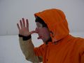
| + | Image:2009-01-12 48 12 thermometer.jpg | It's too warm! | ||
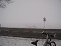
| + | Image:2009-01-12 48 12 view north.jpg | View north to Neutraubling. | ||
| + | Image:2009-01-12 48 12 office.jpg | End of the expedition, arriving at my office. | ||
</gallery> | </gallery> | ||
== Evening visit ([[User:Tomcat|Tomcat]]) == | == Evening visit ([[User:Tomcat|Tomcat]]) == | ||
| − | Originally i had not intended to visit | + | Originally i had not intended to visit today's 48 12 hashpoint. But as things happen - finally i had to left office already in the afternoon to settle things in the city. On a closer look at Google Earth, i realized that the hashpoint was only about 500m away from the shop for animal need, where i usually buy stuff for my cat. So it was a clear decision, that this shop had to be visited today ;-) |
Due to the actual weather conditions it was a fast, simple and clean expedition. I parked my car beside the road an walked along the way between the snowcovered and frozen fields to a point where suddenly some tread marks lead into the field to my right. I just had to follow this trace until i reached the signs "xkcd". Then i took the usual photos and walked back to the road. | Due to the actual weather conditions it was a fast, simple and clean expedition. I parked my car beside the road an walked along the way between the snowcovered and frozen fields to a point where suddenly some tread marks lead into the field to my right. I just had to follow this trace until i reached the signs "xkcd". Then i took the usual photos and walked back to the road. | ||
<gallery> | <gallery> | ||
| + | Image:2009-01-12 48 12 Tomcat at the hashpoint.jpg | Evening visit: Tomcat at the hashpoint. | ||
Image:2009-01-12 48 12 way to the hashpoint.jpg | The way to the hashpoint. | Image:2009-01-12 48 12 way to the hashpoint.jpg | The way to the hashpoint. | ||
Image:2009-01-12 48 12 signs of my predecessor.jpg | Signs of my predecessor at the hashpoint. | Image:2009-01-12 48 12 signs of my predecessor.jpg | Signs of my predecessor at the hashpoint. | ||
| Line 37: | Line 53: | ||
[[Category:Expeditions with photos]] | [[Category:Expeditions with photos]] | ||
[[Category:Coordinates reached]] | [[Category:Coordinates reached]] | ||
| + | {{location|DE|BY|R}} | ||
Latest revision as of 01:22, 8 August 2019
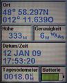
| Mon 12 Jan 2009 in Landshut, Germany: 48.9716227, 12.1939858 geohashing.info google osm bing/os kml crox |
In a frozen, snowy field south of Neutraubling, about 10km southeast of Regensburg. Just 400m northeast of 2008-12-18 48 12. Dawidi and Tomcat were there independently and did not meet.
Morning visit (dawidi)
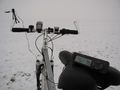
Keeping my tradition of failed Sunrise Geohash attempts, I hit the road nearly an hour later than planned, at around 7:30 in the morning, even though this time, I did not oversleep. It had begun to snow a little, and for the first time in years I cycled a segment of my old way to school among schoolchildren - even while at the university I had only rarely been on the road that early.
As expected, while riding through the snowy, dull morning with a little headwind from the east, I reached and maintained a comfortable operating temperature despite measuring -8°C with a thermometer in a front pocket of my ski jacket. Apart from the last 500m, the way was the same as to the previous nearby hash, and generally a well-known route for me.
At the southern end of Neutraubling, which is essentially a business park, the destination field appeared as a featureless gray void that would require GPS navigation. The last time I was here a month ago at night, it was a black void and similarly featureless.
Except this time, the ground was frozen, so instead of making a mess of my bike on the muddy track, and then making a mess of my boots wading through the sticky field, I could just push my bike across the field easily and stop at the coordinates with essentially clean boots! I took this chance to revenge for last time and stuck my tongue out at the field.
I spent about 45 minutes at the spot, waiting for the thermometer to drop below Tomcat's recent Cold Geohash record of -10.5°C, but it remained at -9.9°C. Once again, the stupid field wasn't cold enough ;-)
While waiting, I walked funny to write "xkcd" into the snow and took pictures.
At around 9:30, my fingers got a bit cold, so I decided to leave and cycle to the office, where I caused a big cheer among my teammates for arriving unusually early, or "less catastrophically late" as I tend to put it.
Into the white void! The hash is a few hundred meters behind the signpost.

Dawidi at the coordinates.
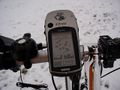
Icy GPS.
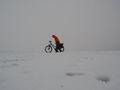
A hashpoint in the middle of the white void.
Thbbthbt! No sticky mud this time!
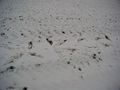
Snowffiti: "xkcd".
It's too warm!
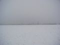
View north to Neutraubling.
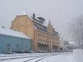
End of the expedition, arriving at my office.


Evening visit (Tomcat)
Originally i had not intended to visit today's 48 12 hashpoint. But as things happen - finally i had to left office already in the afternoon to settle things in the city. On a closer look at Google Earth, i realized that the hashpoint was only about 500m away from the shop for animal need, where i usually buy stuff for my cat. So it was a clear decision, that this shop had to be visited today ;-)
Due to the actual weather conditions it was a fast, simple and clean expedition. I parked my car beside the road an walked along the way between the snowcovered and frozen fields to a point where suddenly some tread marks lead into the field to my right. I just had to follow this trace until i reached the signs "xkcd". Then i took the usual photos and walked back to the road.
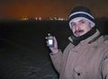
Evening visit: Tomcat at the hashpoint.
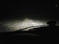
The way to the hashpoint.
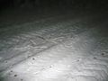
Signs of my predecessor at the hashpoint.
Exactly at the right spot.
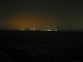
The lights of Neutraubling seen from the hashpoint.


