Difference between revisions of "2009-02-04 52 0"
imported>Benjw (Today's expedition write-up) |
imported>Benjw m (Blast it) |
||
| Line 14: | Line 14: | ||
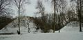
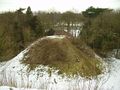
The mounds are around 1900 years old, and there used to be seven of them, which made them the largest such group in Europe. However, 200 years ago some 'enterprising' locals decided to excavate one of the mounds and nick all the items from inside it, all in the name of providing labour for the unemployed. Later, two more of the mounds were all but destroyed when the railway came to this area and was built on top of the barrows' site. These days, however, that particular branch line is long gone. Still, four mounds remain and include the largest in Britain, at 45 feet high. There are wooden stairs so people can climb to the top, and I did. There would have been superb views over the surrounding hills, had there not been quite so many trees in the way. <g> | The mounds are around 1900 years old, and there used to be seven of them, which made them the largest such group in Europe. However, 200 years ago some 'enterprising' locals decided to excavate one of the mounds and nick all the items from inside it, all in the name of providing labour for the unemployed. Later, two more of the mounds were all but destroyed when the railway came to this area and was built on top of the barrows' site. These days, however, that particular branch line is long gone. Still, four mounds remain and include the largest in Britain, at 45 feet high. There are wooden stairs so people can climb to the top, and I did. There would have been superb views over the surrounding hills, had there not been quite so many trees in the way. <g> | ||
| − | Photos were taken, a geocache found, and I moved on. The Essex-Cambridgeshire border was crossed. (Does this qualify me for a [[Border | + | Photos were taken, a geocache found, and I moved on. The Essex-Cambridgeshire border was crossed. (Does this qualify me for a [[Border geohash]]?) I progressed by car as far as possible, but the road ended at a farm, so I pulled up on the verge, and continued on foot, on the public bridleway through the farmyard. It had snowed two days ago, and had not yet thawed completely, so there was a lot of snow and ice everywhere. A small stream flowed westwards beside the footpath, carrying the meltwater away. At the entrance to the farmyard, it was also flowing over the road. I guess it was a bit bigger than it usually is. |
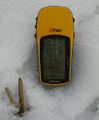
Two fields further, the GPS directed me about 100 metres out onto the snow. There were animal tracks -- something had clearly already beaten me to the hashpoint, although it didn't have the courtesy to leave a note. | Two fields further, the GPS directed me about 100 metres out onto the snow. There were animal tracks -- something had clearly already beaten me to the hashpoint, although it didn't have the courtesy to leave a note. | ||
| Line 30: | Line 30: | ||
| date = 2009-02-04 | | date = 2009-02-04 | ||
| name = [[User:Benjw|Benjw]] | | name = [[User:Benjw|Benjw]] | ||
| − | | image = 2009-02-04 | + | | image = 2009-02-04 benjw at hash.jpg |
}} | }} | ||
| Line 36: | Line 36: | ||
<gallery perrow="3"> | <gallery perrow="3"> | ||
| − | Image:2009-02-04 | + | Image:2009-02-04 barrows.jpg | Two of the barrows |
| − | Image:2009-02-04 | + | Image:2009-02-04 info board.jpg | The information board on the barrows |
| − | Image:2009-02-04 | + | Image:2009-02-04 view from barrows.jpg | Looking north from the tallest barrow |
| − | Image:2009-02-04 | + | Image:2009-02-04 essex.jpg | Crossing the border! |
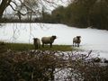
| − | Image:2009-02-04 | + | Image:2009-02-04 sheep.jpg | Friendly sheep at the farm |
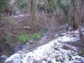
| − | Image:2009-02-04 | + | Image:2009-02-04 stream.jpg | A stream running alongside the path |
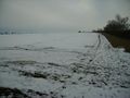
| − | Image:2009-02-04 | + | Image:2009-02-04 field.jpg | Hashpoint 100m this way |
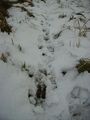
| − | Image:2009-02-04 | + | Image:2009-02-04 tracks.jpg | Something's beaten me to it |
| − | Image:2009-02-04 | + | Image:2009-02-04 proof.jpg | Found it! |
| − | Image:2009-02-04 | + | Image:2009-02-04 benjw at hash.jpg | [[User:Benjw|Benjw]] at the hashpoint |
| − | Image:2009-02-04 | + | Image:2009-02-04 east.jpg | The view east |
| − | Image:2009-02-04 | + | Image:2009-02-04 west.jpg | The view west towards the farm |
</gallery> | </gallery> | ||
Revision as of 20:38, 4 February 2009
| Wed 4 Feb 2009 in 52,0: 52.0505257, 0.3319136 geohashing.info google osm bing/os kml crox |
Today's hashpoint was in a field (just for a change) just south of a public bridleway between Ashdon, Essex, and Castle Camps, Cambridgeshire. Benjw was working only 10 miles away in Duxford until mid-afternoon and made it to the hash at about 4pm.
The expedition
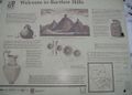
While checking where today's hashpoint was, and searching the geocache database for anything nearby, I learned something new: there are some ancient barrows (burial mounds) in the village of Bartlow, just north of today's hashpoint and only about a mile or two south of the A1307 Cambridge to Haverhill road, along which I've driven many times. Naturally, I immediately decided to visit this historical site on the way. Who says hashing is a pointless activity?
The mounds are around 1900 years old, and there used to be seven of them, which made them the largest such group in Europe. However, 200 years ago some 'enterprising' locals decided to excavate one of the mounds and nick all the items from inside it, all in the name of providing labour for the unemployed. Later, two more of the mounds were all but destroyed when the railway came to this area and was built on top of the barrows' site. These days, however, that particular branch line is long gone. Still, four mounds remain and include the largest in Britain, at 45 feet high. There are wooden stairs so people can climb to the top, and I did. There would have been superb views over the surrounding hills, had there not been quite so many trees in the way. <g>
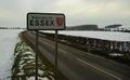
Photos were taken, a geocache found, and I moved on. The Essex-Cambridgeshire border was crossed. (Does this qualify me for a Border geohash?) I progressed by car as far as possible, but the road ended at a farm, so I pulled up on the verge, and continued on foot, on the public bridleway through the farmyard. It had snowed two days ago, and had not yet thawed completely, so there was a lot of snow and ice everywhere. A small stream flowed westwards beside the footpath, carrying the meltwater away. At the entrance to the farmyard, it was also flowing over the road. I guess it was a bit bigger than it usually is.
Two fields further, the GPS directed me about 100 metres out onto the snow. There were animal tracks -- something had clearly already beaten me to the hashpoint, although it didn't have the courtesy to leave a note.
This area contains a lot of fields, farms and small villages, so it was very peaceful (and also rather chilly). A selection of the usual photos were taken, then I retraced my steps the half-mile to the car, and headed home.
Shiny ribbons earned
I didn't take a thermometer so I'm not sure if this was a Frozen Geohash or not, although there was certainly plenty of snow and ice around.
Benjw earned the Land geohash achievement
|
Photographic documentation
Two of the barrows
The information board on the barrows
Looking north from the tallest barrow
Crossing the border!
Friendly sheep at the farm
A stream running alongside the path
Hashpoint 100m this way
Something's beaten me to it
Found it!
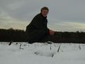
Benjw at the hashpoint
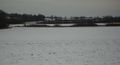
The view east
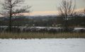
The view west towards the farm


