Difference between revisions of "2009-02-14 32 -94"
imported>Robyn (First save using the annoying but effective insta-expedition-template.) |
imported>FippeBot m (Location) |
||
| (2 intermediate revisions by one other user not shown) | |||
| Line 1: | Line 1: | ||
| − | |||
<!-- Please substitute appropriate things for IMAGE, LAT, LON, and DATE (YYYY-MM-DD format) --> | <!-- Please substitute appropriate things for IMAGE, LAT, LON, and DATE (YYYY-MM-DD format) --> | ||
| − | [[Image: | + | [[Image:2009-02-14 32 -94.View.JPG|thumb|left]] |
{{meetup graticule | {{meetup graticule | ||
| − | | map=<map lat= | + | | map=<map lat=32 lon=-94 date=2009-02-14/> |
| − | | lat= | + | | lat=32 |
| − | | lon= | + | | lon=-94 |
| − | | date= | + | | date=2009-02-14 |
}} | }} | ||
| Line 12: | Line 11: | ||
__NOTOC__ | __NOTOC__ | ||
== Participants == | == Participants == | ||
| − | + | [[User:Robyn|Robyn]] | |
== Plans == | == Plans == | ||
| − | + | I knew I would be flying in this area but am careful not to steer for a geohash point if there is a more efficient way to do the trip. My plan was to enter the point in the GPS and simply watch to see if I was going to get there, prepared to document, but to make no other moves. When I saw the area I was working in, I didn't expect to be able to get it. It's point 1143, the default number in the GPS. I wasn't feeling fancy enough to name it XKCD. | |
== Expedition == | == Expedition == | ||
| + | I flew parallel lines close to the point, and my tracks (parallel white lines) on the GPS show that I was there yesterday. (I already have the [[Déjà Vu Geohash|Déjà-vu ribbon]], though). So close but so far away. Six point one miles, as of the picture, and I believe I got as close as five miles. I gently surrendered to the geohashing gods and continued inching further from the point with each pass. | ||
| + | When we were done the lines, I was asked to fly to another point, B034 on the GPS and when I programmed that in, the pink line went straight through 1143. I added 1143 as a waypoint en route to B034, and got out the camera. The GPS shows the distance and bearing to 1143, the geohash, until two seconds before reaching it. The line from the geohash on to my real destination can be seen on the screen. At one second before the point, the distance remaining switches to the distance to the next point. I am satisfied that I passed over the point within the tolerance and I think a reasonable person will conclude that I must have. | ||
| − | + | Looking at the photos, I see that the screen I photographed does is not set to display the current Lat-Long coordinates so I could be at ''any'' point, and just claiming it to be the geohash. I know I entered it correctly, however, and if you click through on peeron you can see it is just by Smithland, north of Caddo Lake. As it wasn't four p.m. and wasn't a virgin graticule this geohash doesn't count towards anything disputable, so I'm logging a success. | |
| + | It's kind of startling how often where I am going is right over a geohash. Someone with some statistics training should figure out whether I am a geohashing goddess or just obeying the laws of probability. | ||
== Photos == | == Photos == | ||
| − | <gallery | + | <gallery> |
| − | Image:2009- | + | Image:2009-02-14 32 -94.NotThere.JPG | The point is at one end of the pink line. I am at the other. Or at least was before I got my camera out. |
| − | Image:2009- | + | Image:2009-02-14 32 -94.View.JPG | And the point is five miles off my left wing, down there, where I also am not. |
| + | Image:2009-02-14 32 -94.OnTheWay.JPG | But the point happens to be on the way to where I am going next, just eight seconds/ 0.4 miles ahead. | ||
| + | Image:2009-02-14 32 -94.2secs.JPG | Now the point is two seconds ahead, just over five hundred feet away, and you can see that I am still heading towards it at a rate of almost three hundred feet per second. | ||
| + | Image:2009-02-14 32 -94.SwitchingNext.JPG | The point is still perhaps 100 feet ahead and slightly to the left, but the GPS has turned its attention to the next point. | ||
</gallery> | </gallery> | ||
| − | |||
| − | |||
| − | |||
| − | |||
| − | |||
| − | |||
| − | |||
| − | |||
[[Category:Expeditions]] | [[Category:Expeditions]] | ||
[[Category:Expeditions with photos]] | [[Category:Expeditions with photos]] | ||
| − | |||
| − | |||
| − | |||
| − | |||
| − | |||
[[Category:Coordinates reached]] | [[Category:Coordinates reached]] | ||
| − | + | {{location|US|TX|MN}} | |
| − | |||
| − | |||
| − | |||
| − | |||
| − | |||
| − | |||
| − | |||
| − | |||
| − | |||
Latest revision as of 02:06, 6 August 2019

| Sat 14 Feb 2009 in 32,-94: 32.8253397, -94.1710255 geohashing.info google osm bing/os kml crox |
Participants
Plans
I knew I would be flying in this area but am careful not to steer for a geohash point if there is a more efficient way to do the trip. My plan was to enter the point in the GPS and simply watch to see if I was going to get there, prepared to document, but to make no other moves. When I saw the area I was working in, I didn't expect to be able to get it. It's point 1143, the default number in the GPS. I wasn't feeling fancy enough to name it XKCD.
Expedition
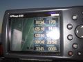
I flew parallel lines close to the point, and my tracks (parallel white lines) on the GPS show that I was there yesterday. (I already have the Déjà-vu ribbon, though). So close but so far away. Six point one miles, as of the picture, and I believe I got as close as five miles. I gently surrendered to the geohashing gods and continued inching further from the point with each pass.
When we were done the lines, I was asked to fly to another point, B034 on the GPS and when I programmed that in, the pink line went straight through 1143. I added 1143 as a waypoint en route to B034, and got out the camera. The GPS shows the distance and bearing to 1143, the geohash, until two seconds before reaching it. The line from the geohash on to my real destination can be seen on the screen. At one second before the point, the distance remaining switches to the distance to the next point. I am satisfied that I passed over the point within the tolerance and I think a reasonable person will conclude that I must have.
Looking at the photos, I see that the screen I photographed does is not set to display the current Lat-Long coordinates so I could be at any point, and just claiming it to be the geohash. I know I entered it correctly, however, and if you click through on peeron you can see it is just by Smithland, north of Caddo Lake. As it wasn't four p.m. and wasn't a virgin graticule this geohash doesn't count towards anything disputable, so I'm logging a success.
It's kind of startling how often where I am going is right over a geohash. Someone with some statistics training should figure out whether I am a geohashing goddess or just obeying the laws of probability.
Photos
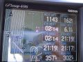
The point is at one end of the pink line. I am at the other. Or at least was before I got my camera out.
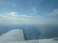
And the point is five miles off my left wing, down there, where I also am not.
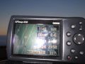
But the point happens to be on the way to where I am going next, just eight seconds/ 0.4 miles ahead.
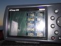
Now the point is two seconds ahead, just over five hundred feet away, and you can see that I am still heading towards it at a rate of almost three hundred feet per second.
The point is still perhaps 100 feet ahead and slightly to the left, but the GPS has turned its attention to the next point.


