Difference between revisions of "2009-02-21 -34 138"
imported>Joannac m (and we sang dirges in the dark) |
m (More specific location) |
||
| (2 intermediate revisions by 2 users not shown) | |||
| Line 1: | Line 1: | ||
{{meetup graticule | {{meetup graticule | ||
| − | |||
| lat=-34 | | lat=-34 | ||
| lon=138 | | lon=138 | ||
| Line 26: | Line 25: | ||
I was in Adelaide for the weekend and Mum decided that we were going to spend Saturday driving round the countryside 'looking for dead people' (as Dad put it...) Mum's keen on family history at the moment and it didn't take much convincing to come home via today's Geohash. | I was in Adelaide for the weekend and Mum decided that we were going to spend Saturday driving round the countryside 'looking for dead people' (as Dad put it...) Mum's keen on family history at the moment and it didn't take much convincing to come home via today's Geohash. | ||
| − | We headed North from Adelaide to a little town of Owen. Not much was happening in the town of Owen, until we drove past the bowling club, which was going off on a Saturday morning. Driving past the old buildings in the town we found a building with a plaque that my Great, Great, Grandfather built, with some graffiti that Mum did not approve of, but Dad and I found quietly amusing... <font color=green size=1>Owen does have some things going for it. The town has a very impressive | + | We headed North from Adelaide to a little town of Owen. Not much was happening in the town of Owen, until we drove past the bowling club, which was going off on a Saturday morning. Driving past the old buildings in the town we found a building with a plaque that my Great, Great, Grandfather built, with some graffiti that Mum did not approve of, but Dad and I found quietly amusing... <font color=green size=1>Owen does have some things going for it. The town has a very impressive Christmas lights display and competition, considering its size, with most of the occupied houses - like all country Australia, Owen is suffering from drought and the mass migration to the cities - taking part. Owen also has a fine golf course around the outskirts of town where your correspondent played his first ever whole game of golf, scoring a slightly overpar 143 for 18 holes. </font> |
| − | From there we drove along some very dry and dusty country roads to a little cemetery on the side of the road where we found the graves of my Great, Great, Great Grandfather and Grandmother. They were the first of our family to come from Scotland to Australia in 1864. <font color=green size=1>The colony of South Australia was proclaimed in 1836, and by 1850 colonists - unaided by convict labour unlike the other non-convict state of Western Australia - had | + | From there we drove along some very dry and dusty country roads to a little cemetery on the side of the road where we found the graves of my Great, Great, Great Grandfather and Grandmother. They were the first of our family to come from Scotland to Australia in 1864. <font color=green size=1>The colony of South Australia was proclaimed in 1836, and by 1850 colonists - unaided by convict labour unlike the other non-convict state of Western Australia - had traveled overland and established towns as far away as Port Pirie, some 400km north. There are many hundreds of tiny cemeteries spread throughout the state, making many opportunities for historical investigation and/or coffin potato geohashes.</font> |
We then went to the Barossa valley for lunch. When driving through the town of Kapunda we came across a giant statue. We had found MAP, the Cornish Miner who stands 8 metres tall! | We then went to the Barossa valley for lunch. When driving through the town of Kapunda we came across a giant statue. We had found MAP, the Cornish Miner who stands 8 metres tall! | ||
| Line 36: | Line 35: | ||
As we drove through the Barossa the landscape changed quickly from the dry valley of Owen to the green grape growing region of the Barossa Valley. There is really only one river in South Australia and most of the water used in this region is pumped up from the Murray River. <font color=green size=1>The Barossa is Australia's prime wine-producing region and South Australia's premier tourist attraction. If you plan on visiting give yourself at least a week and get somebody else to drive.</font> | As we drove through the Barossa the landscape changed quickly from the dry valley of Owen to the green grape growing region of the Barossa Valley. There is really only one river in South Australia and most of the water used in this region is pumped up from the Murray River. <font color=green size=1>The Barossa is Australia's prime wine-producing region and South Australia's premier tourist attraction. If you plan on visiting give yourself at least a week and get somebody else to drive.</font> | ||
| − | We then drove down through the reservoirs and dams that hold Adelaide's water supply. They were dry. Some, completely empty. It was a very sobering moment to realise that 'The River Murry Crisis' so often | + | We then drove down through the reservoirs and dams that hold Adelaide's water supply. They were dry. Some, completely empty. It was a very sobering moment to realise that 'The River Murry Crisis' so often trivialized in New South Wales (up river) was worse than I had imagined. Especially considering that the river Torrens that runs through the middle Adelaide had its weir left open last week and millions of litres of water were drained out to sea, leaving the city's lake a giant mudflat (and exposing all sorts of debris, including a car...) <font color=green size=1>Thankfully, due to intervention by the federal government and agreement by most of the states involved, it seems that some relief is on its way for the Murray river, providing the Victorian government agrees to the lucrative deal being proposed in order that South Australia - the driest state in the country - might get some precious water rather than it being used for inefficient flood irrigation. Unfortunately it will be too late for the delicate ecosystems of 'the Lower Lakes' Alexandrina and Albert -the water sources that were the prime motivation for the site of Adelaide- where a pipeline has been built 2.5km into the lake to pump water to houses that were once on the waterfront, and the Coorong, the 100km long lagoon that is a breeding ground for fish and migrating birds from Russia and Alaska, which are almost certainly damaged beyond repair due to a build up of salinity in a land thirsting for water.</font> |
Weaving around the Adelaide Hills we finally came to the town of Cuddly Creek and found our way down Snake Gully Road where we a gate was locked across out path with a sign saying 'Private Property'. OH NO! But wait, a red sign on the fence post, the road was a part of the Heysen Trail a public track that extents 1200 km from the south of the state to the Flinders Rangers north of Adelaide. So, I was in luck. Mum and Dad decided to wait in the car so I set off down the track (with warnings of 'be careful', 'watch out for snakes' and 'don't go climbing any cliffs')... <font color=green size=1>Oh damn, looks like I picked the wrong road...more about that later, though.</font> | Weaving around the Adelaide Hills we finally came to the town of Cuddly Creek and found our way down Snake Gully Road where we a gate was locked across out path with a sign saying 'Private Property'. OH NO! But wait, a red sign on the fence post, the road was a part of the Heysen Trail a public track that extents 1200 km from the south of the state to the Flinders Rangers north of Adelaide. So, I was in luck. Mum and Dad decided to wait in the car so I set off down the track (with warnings of 'be careful', 'watch out for snakes' and 'don't go climbing any cliffs')... <font color=green size=1>Oh damn, looks like I picked the wrong road...more about that later, though.</font> | ||
| Line 62: | Line 61: | ||
==Cudlee Creek: A Photodiary by U.W.Owl, Gentleman Explorer== | ==Cudlee Creek: A Photodiary by U.W.Owl, Gentleman Explorer== | ||
<gallery caption="Photo Gallery (text coming soon)" widths="400px" heights="400px" perrow="2"> | <gallery caption="Photo Gallery (text coming soon)" widths="400px" heights="400px" perrow="2"> | ||
| − | Image:-34_138_2009-02-20_UO_001.jpg|Having | + | Image:-34_138_2009-02-20_UO_001.jpg|Having canceled my plans for the afternoon due to a double booking, I was pleasantly suprised to see my local geohash was on the end of a road in a local(ish) conservation park. Without hesitating to check any more details, I was out the driveway and away. There is only one road out to the area I wished to go, the accurately named Gorge Road, but as I found when I got there, a section of it was under repair. |
| − | Image:-34_138_2009-02-20_UO_002.jpg| Detour! Geohashing is just one big detour anyway, so taking a little one didn't bother me too much. Luckily, I was soon back on the dangerous and often Gorge road (as shown | + | Image:-34_138_2009-02-20_UO_002.jpg| Detour! Geohashing is just one big detour anyway, so taking a little one didn't bother me too much. Luckily, I was soon back on the dangerous and often Gorge road (as shown by the numerous roadside memorials) and on my way up to the hash. |
Image:-34_138_2009-02-20_UO_003.jpg|I proceeded through the town of Cudlee Creek, but had it in my head that I needed Horsnell Gully road, not Snake Gully road. Unbeknownst to me, if I had taken Snake Gully road, not only would I have had a flat and easy jaunt to the hash and my first 4pm meetup, but I would have met a fellow geohasher. Living up to my name, however, I found myself at the end of Horsnell Gully Road, with 800m to go for the hash, and beaten again by private property. | Image:-34_138_2009-02-20_UO_003.jpg|I proceeded through the town of Cudlee Creek, but had it in my head that I needed Horsnell Gully road, not Snake Gully road. Unbeknownst to me, if I had taken Snake Gully road, not only would I have had a flat and easy jaunt to the hash and my first 4pm meetup, but I would have met a fellow geohasher. Living up to my name, however, I found myself at the end of Horsnell Gully Road, with 800m to go for the hash, and beaten again by private property. | ||
Image:-34_138_2009-02-20_UO_006.jpg|A more pressing concern, though, was that I had driven at least 1km up a narrow track, with no opportunity to turn around. It looked like I had a long trip in reverse gear in front of (or behind, I suppose) me. | Image:-34_138_2009-02-20_UO_006.jpg|A more pressing concern, though, was that I had driven at least 1km up a narrow track, with no opportunity to turn around. It looked like I had a long trip in reverse gear in front of (or behind, I suppose) me. | ||
| Line 72: | Line 71: | ||
Image:-34_138_2009-02-20_UO_021.jpg|UnwiseOwl on the other side of the drain...And so, I got back in the car, and proceeded south. A bit disappointed not to get the cache, but happy about a fun little adventure and discovery of a funky drain. | Image:-34_138_2009-02-20_UO_021.jpg|UnwiseOwl on the other side of the drain...And so, I got back in the car, and proceeded south. A bit disappointed not to get the cache, but happy about a fun little adventure and discovery of a funky drain. | ||
Image:-34_138_2009-02-20_UO_049.jpg|I was heading home on Fox road, about 2km west of the hashsite, when I saw a little fire track running up the hill and into the bush. Since it was heading in more or less the right direction, and I had some time to kill, I parked the car on the verge and went for a wander. IT turned out to be part of the Mawson trail, SA's second most famous bush track, this one for cyclists. Unfortunately, it started going up, steeply, rather fast. And since I am an unfit nerd in a suit I forgot to take off, I was overheating a little. | Image:-34_138_2009-02-20_UO_049.jpg|I was heading home on Fox road, about 2km west of the hashsite, when I saw a little fire track running up the hill and into the bush. Since it was heading in more or less the right direction, and I had some time to kill, I parked the car on the verge and went for a wander. IT turned out to be part of the Mawson trail, SA's second most famous bush track, this one for cyclists. Unfortunately, it started going up, steeply, rather fast. And since I am an unfit nerd in a suit I forgot to take off, I was overheating a little. | ||
| − | Image:-34_138_2009-02-20_UO_029.jpg|I finally reached the top of the hill (yes, that is my car down there), but there seemed to be no track going in the right direction. So, as I sat pondering what my next move would be, my sensible side saying that if I left now I could claim the private property AND MNB | + | Image:-34_138_2009-02-20_UO_029.jpg|I finally reached the top of the hill (yes, that is my car down there), but there seemed to be no track going in the right direction. So, as I sat pondering what my next move would be, my sensible side saying that if I left now I could claim the private property AND MNB consolation prizes, and my stubborn side insisting that it couldn't possibly be as bad as the last time I struck off across the bush, I ate some chocolate and decided I could never forgive myself if there was a way to the hash, so I took one of the tracks and headed down the hill. |
Image:-34_138_2009-02-20_UO_032.jpg|Eventually I ran out of tracks, but I was only 400m from the hash and had already decided to be a stubborn bugger. So, regretting my inappropriate footwear (I have this thing for socks and sandals) I headed off down the hill some more. Well aware that I was going to have to climb back up again afterwards. | Image:-34_138_2009-02-20_UO_032.jpg|Eventually I ran out of tracks, but I was only 400m from the hash and had already decided to be a stubborn bugger. So, regretting my inappropriate footwear (I have this thing for socks and sandals) I headed off down the hill some more. Well aware that I was going to have to climb back up again afterwards. | ||
Image:-34_138_2009-02-20_UO_034.jpg|After a crazed rush down hill, I appeared on a bush track, and following it, I got to this junction. Appropriately, I had been walking on Pratt's track, but now I had reached my beloved Heysen Trail. | Image:-34_138_2009-02-20_UO_034.jpg|After a crazed rush down hill, I appeared on a bush track, and following it, I got to this junction. Appropriately, I had been walking on Pratt's track, but now I had reached my beloved Heysen Trail. | ||
| − | Image:-34_138_2009-02-20_UO_035.jpg|And lo and behold, here was a lovely little campground. Had I known that as I was walking, people were dreaming up the camping | + | Image:-34_138_2009-02-20_UO_035.jpg|And lo and behold, here was a lovely little campground. Had I known that as I was walking, people were dreaming up the camping achievement, I almost certainly would have stayed here overnight, but instead I just stopped for a minute or two for a look around. |
Image:-34_138_2009-02-20_UO_037.jpg|Not, it's not a Kubby House. This is an official Heysen Trail camping shelter. Most of them are a lot bigger than this, but maybe they were running out of money by this bit or something. | Image:-34_138_2009-02-20_UO_037.jpg|Not, it's not a Kubby House. This is an official Heysen Trail camping shelter. Most of them are a lot bigger than this, but maybe they were running out of money by this bit or something. | ||
Image:-34_138_2009-02-20_UO_040.jpg|The view from the hash site, just 100 metres away from the campsite up a very slippery hill, especially for someone inappropriately attired like myself. | Image:-34_138_2009-02-20_UO_040.jpg|The view from the hash site, just 100 metres away from the campsite up a very slippery hill, especially for someone inappropriately attired like myself. | ||
Image:-34_138_2009-02-20_UO_041.jpg|An owl at the hash. Looking silly, of course. | Image:-34_138_2009-02-20_UO_041.jpg|An owl at the hash. Looking silly, of course. | ||
| − | Image:-34_138_2009-02-20_UO_042.jpg|I've been to more than a dozen hashes, and never got even close to meeting another person at any of them. Imagine my suprise when I found a log by Kate in the logbook at the nearby campsite. Of course, this probably made me | + | Image:-34_138_2009-02-20_UO_042.jpg|I've been to more than a dozen hashes, and never got even close to meeting another person at any of them. Imagine my suprise when I found a log by Kate in the logbook at the nearby campsite. Of course, this probably made me ineligible for the Saturday award, as I was there 45 minutes late, and somebody else could prove it, but I was pleased just to have been close, though I was kicking myself, as Kate had obviously found a more efficient route of reaching the hash than I had. So I signed the book, and wrote a nice little note for fellow bushwalkers about our wacky sport, in my spidery, illegible script, of course. |
Image:-34_138_2009-02-20_UO_043.jpg|Having a logbook kinda makes it feel like a geocache, really. | Image:-34_138_2009-02-20_UO_043.jpg|Having a logbook kinda makes it feel like a geocache, really. | ||
Image:-34_138_2009-02-20_UO_044.jpg|I decided to go back a different way, which was just as well, as I got to see this cool little valley full of ferns amongst the forest. The world is full of exciting little secret places, a drain, a campsite, a hidden valley, none of which I woudl ever have discovered if it weren't for geohashing. | Image:-34_138_2009-02-20_UO_044.jpg|I decided to go back a different way, which was just as well, as I got to see this cool little valley full of ferns amongst the forest. The world is full of exciting little secret places, a drain, a campsite, a hidden valley, none of which I woudl ever have discovered if it weren't for geohashing. | ||
Image:-34_138_2009-02-20_UO_045.jpg|Steep (and it was). Unfortunately, this sign came a little too late for me. There was also a 'Track Impassable' one (It wasn't). | Image:-34_138_2009-02-20_UO_045.jpg|Steep (and it was). Unfortunately, this sign came a little too late for me. There was also a 'Track Impassable' one (It wasn't). | ||
| − | Image:-34_138_2009-02-20_UO_048.jpg|Back where I had been thinking of giving up, at the top of the hill. Satisfied from a | + | Image:-34_138_2009-02-20_UO_048.jpg|Back where I had been thinking of giving up, at the top of the hill. Satisfied from a fulfilling journey, I was very glad I hadn't taken this sign's advice when I'd first seen it. |
Image:-34_138_2009-02-20_UO_052.jpg|Back at my car. Time to pull the prickles out of my suit and get back home. | Image:-34_138_2009-02-20_UO_052.jpg|Back at my car. Time to pull the prickles out of my suit and get back home. | ||
Image:-34_138_2009-02-20_UO_053.jpg|But not before a stop at the local cafe. And look, they had geoslushies! | Image:-34_138_2009-02-20_UO_053.jpg|But not before a stop at the local cafe. And look, they had geoslushies! | ||
| − | Image:-34_138_2009-02-20_UO_054.jpg|I settled for a caramel milkshake and a line in the | + | Image:-34_138_2009-02-20_UO_054.jpg|I settled for a caramel milkshake and a line in the guest book. After this photo was taken I added my location as (the internet). |
Image:-34_138_2009-02-20_UO_055.jpg|Kinda glad I was too full after my milkshake to contemplate a 'Cudlee Stack', although it does sound kind of tasty. | Image:-34_138_2009-02-20_UO_055.jpg|Kinda glad I was too full after my milkshake to contemplate a 'Cudlee Stack', although it does sound kind of tasty. | ||
Image:-34_138_2009-02-20_UO_056.jpg|I was an hour too late to get hashcards :( | Image:-34_138_2009-02-20_UO_056.jpg|I was an hour too late to get hashcards :( | ||
| − | Image:-34_138_2009-02-20_UO_058.jpg|A map of what I did wrong. Mind you, google has no idea what is going on there either. That 'Cudlee Creek Road' doesn't exist at all, and Snake Gully Road doesn't go that far...Anyway, the red is the route of the | + | Image:-34_138_2009-02-20_UO_058.jpg|A map of what I did wrong. Mind you, google has no idea what is going on there either. That 'Cudlee Creek Road' doesn't exist at all, and Snake Gully Road doesn't go that far...Anyway, the red is the route of the Heysen trail, where I should have gone, the blue is where I did go, and the pink is me having fun scribbling on the map in MSPaint. |
</gallery> | </gallery> | ||
| + | |||
| + | |||
| + | [[Category:Expeditions]] | ||
| + | [[Category:Coordinates reached]] | ||
| + | [[Category:Expeditions with photos]] | ||
| + | {{location|AU|SA|AH}} | ||
Latest revision as of 11:36, 1 August 2020
| Sat 21 Feb 2009 in -34,138: -34.8655206, 138.8235131 geohashing.info google osm bing/os kml crox |
Contents
Location
In the bush south of the amusingly named Adelaide Hills town of Cuddly Creek.
Attendees
Kate earned the Land geohash achievement
|
Kate's Report (with annotations of a historical bent for the thinking man or lady by U.W.Owl, Esq.)
I was in Adelaide for the weekend and Mum decided that we were going to spend Saturday driving round the countryside 'looking for dead people' (as Dad put it...) Mum's keen on family history at the moment and it didn't take much convincing to come home via today's Geohash.
We headed North from Adelaide to a little town of Owen. Not much was happening in the town of Owen, until we drove past the bowling club, which was going off on a Saturday morning. Driving past the old buildings in the town we found a building with a plaque that my Great, Great, Grandfather built, with some graffiti that Mum did not approve of, but Dad and I found quietly amusing... Owen does have some things going for it. The town has a very impressive Christmas lights display and competition, considering its size, with most of the occupied houses - like all country Australia, Owen is suffering from drought and the mass migration to the cities - taking part. Owen also has a fine golf course around the outskirts of town where your correspondent played his first ever whole game of golf, scoring a slightly overpar 143 for 18 holes.
From there we drove along some very dry and dusty country roads to a little cemetery on the side of the road where we found the graves of my Great, Great, Great Grandfather and Grandmother. They were the first of our family to come from Scotland to Australia in 1864. The colony of South Australia was proclaimed in 1836, and by 1850 colonists - unaided by convict labour unlike the other non-convict state of Western Australia - had traveled overland and established towns as far away as Port Pirie, some 400km north. There are many hundreds of tiny cemeteries spread throughout the state, making many opportunities for historical investigation and/or coffin potato geohashes.
We then went to the Barossa valley for lunch. When driving through the town of Kapunda we came across a giant statue. We had found MAP, the Cornish Miner who stands 8 metres tall!
His Plaque reads: "MAP is a monument to the profound, role and contribution of the Cornish miner in the Kapunda and in due course in other mines in South Australia. The Kapunda mine, established in 1844, was the first successful metal mine in Australia and contributed greatly to the economic development of South Australia. Up to its closure in 1878 ore to the value of more than £1 million was produced and up to 340 men and boys, mainly from Cornwall were employed." The colony of South Australia was in financial trouble when the copper deposits at Kapunda were discovered, and the town of Kapunda - and nearby Burra, long the home of the worlds largest mine, creatively named the 'Burra Monster Mine' - were instrumental in the survival of the colony. Map himself is part of the well documented Australian tradition of building great big things, and he is so popular that when he was destroyed by arson in 2006, donations amounting to more than $200,000AU flowed in from around the country to rebuild him.
As we drove through the Barossa the landscape changed quickly from the dry valley of Owen to the green grape growing region of the Barossa Valley. There is really only one river in South Australia and most of the water used in this region is pumped up from the Murray River. The Barossa is Australia's prime wine-producing region and South Australia's premier tourist attraction. If you plan on visiting give yourself at least a week and get somebody else to drive.
We then drove down through the reservoirs and dams that hold Adelaide's water supply. They were dry. Some, completely empty. It was a very sobering moment to realise that 'The River Murry Crisis' so often trivialized in New South Wales (up river) was worse than I had imagined. Especially considering that the river Torrens that runs through the middle Adelaide had its weir left open last week and millions of litres of water were drained out to sea, leaving the city's lake a giant mudflat (and exposing all sorts of debris, including a car...) Thankfully, due to intervention by the federal government and agreement by most of the states involved, it seems that some relief is on its way for the Murray river, providing the Victorian government agrees to the lucrative deal being proposed in order that South Australia - the driest state in the country - might get some precious water rather than it being used for inefficient flood irrigation. Unfortunately it will be too late for the delicate ecosystems of 'the Lower Lakes' Alexandrina and Albert -the water sources that were the prime motivation for the site of Adelaide- where a pipeline has been built 2.5km into the lake to pump water to houses that were once on the waterfront, and the Coorong, the 100km long lagoon that is a breeding ground for fish and migrating birds from Russia and Alaska, which are almost certainly damaged beyond repair due to a build up of salinity in a land thirsting for water.
Weaving around the Adelaide Hills we finally came to the town of Cuddly Creek and found our way down Snake Gully Road where we a gate was locked across out path with a sign saying 'Private Property'. OH NO! But wait, a red sign on the fence post, the road was a part of the Heysen Trail a public track that extents 1200 km from the south of the state to the Flinders Rangers north of Adelaide. So, I was in luck. Mum and Dad decided to wait in the car so I set off down the track (with warnings of 'be careful', 'watch out for snakes' and 'don't go climbing any cliffs')... Oh damn, looks like I picked the wrong road...more about that later, though.
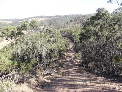
The track turned out to be a lovely amble alongside some farmland before ending in the Mt Crawford National Park. The hash point was just off the track amongst the gum trees, a very pretty spot.
As I stomped back to the track (stomping-hoping to scare the snakes away before I stepped on them) I noticed a sign that said there was an unofficial logbook 100m up the track. I climbed the gate and found a lovely campsite with a logbook that I signed, but alas, it didn't look like any other Geohashers had been there, which would have been a shame as it was one of the best hash points I have ever visited.
A lovely walk through an area that I really hope to return to one day.
I then remembered that Mum and Dad were waiting for me so I ran back to the car. Mum hadn't wasted her time however, she had located another grave to visit on the way home! Searching through the St Bernards Cemetery in Magill we found the grave of my Great, Great, Great, Great Grandfather and Grandmother!
It was a wonderful day exploring South Australia!


Cudlee Creek: A Photodiary by U.W.Owl, Gentleman Explorer
- Photo Gallery (text coming soon)
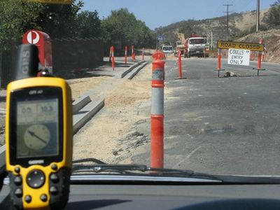
Having canceled my plans for the afternoon due to a double booking, I was pleasantly suprised to see my local geohash was on the end of a road in a local(ish) conservation park. Without hesitating to check any more details, I was out the driveway and away. There is only one road out to the area I wished to go, the accurately named Gorge Road, but as I found when I got there, a section of it was under repair.
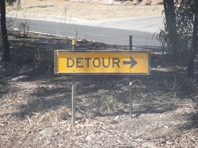
Detour! Geohashing is just one big detour anyway, so taking a little one didn't bother me too much. Luckily, I was soon back on the dangerous and often Gorge road (as shown by the numerous roadside memorials) and on my way up to the hash.
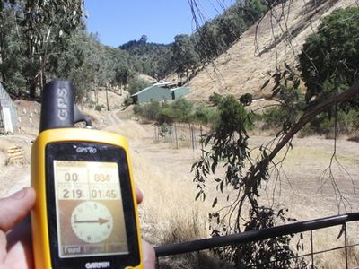
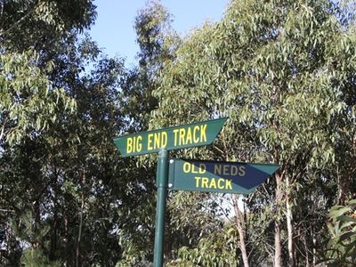
I proceeded through the town of Cudlee Creek, but had it in my head that I needed Horsnell Gully road, not Snake Gully road. Unbeknownst to me, if I had taken Snake Gully road, not only would I have had a flat and easy jaunt to the hash and my first 4pm meetup, but I would have met a fellow geohasher. Living up to my name, however, I found myself at the end of Horsnell Gully Road, with 800m to go for the hash, and beaten again by private property.

A more pressing concern, though, was that I had driven at least 1km up a narrow track, with no opportunity to turn around. It looked like I had a long trip in reverse gear in front of (or behind, I suppose) me.
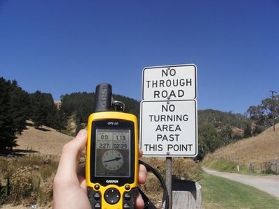
Turns out there had been a sign, when I finally got back to a decent road, but paying attention to road signs never gets you anywhere. As I was taking this photo, a car headed up the track I'd just come back down, thankfully they wouldn't be meeting a car reversing down there. That would have been unfortunate and embarrassing.
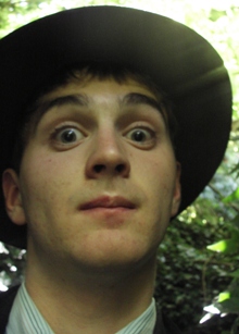
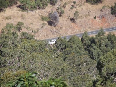
Since I'd given up on attaining the hash, I stopped at a likely looking spot on the side of the road, determined to finally get a Calendar Girl Achievement photograph. This obviously isn't it..it's pretty pixellated.
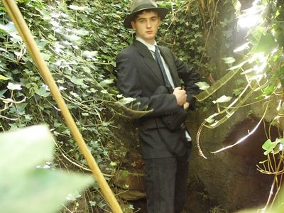
UnwiseOwl in a drain...
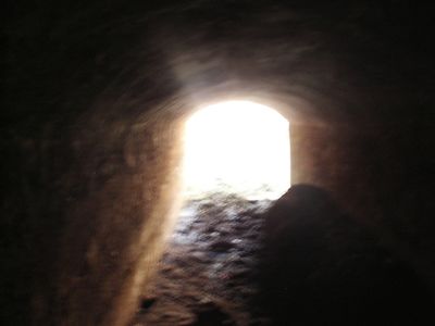
UnwiseOwl in a tunnel...
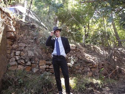
UnwiseOwl on the other side of the drain...And so, I got back in the car, and proceeded south. A bit disappointed not to get the cache, but happy about a fun little adventure and discovery of a funky drain.
I was heading home on Fox road, about 2km west of the hashsite, when I saw a little fire track running up the hill and into the bush. Since it was heading in more or less the right direction, and I had some time to kill, I parked the car on the verge and went for a wander. IT turned out to be part of the Mawson trail, SA's second most famous bush track, this one for cyclists. Unfortunately, it started going up, steeply, rather fast. And since I am an unfit nerd in a suit I forgot to take off, I was overheating a little.
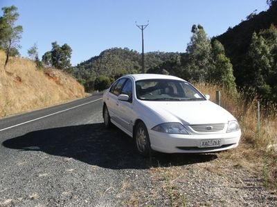
I finally reached the top of the hill (yes, that is my car down there), but there seemed to be no track going in the right direction. So, as I sat pondering what my next move would be, my sensible side saying that if I left now I could claim the private property AND MNB consolation prizes, and my stubborn side insisting that it couldn't possibly be as bad as the last time I struck off across the bush, I ate some chocolate and decided I could never forgive myself if there was a way to the hash, so I took one of the tracks and headed down the hill.
Eventually I ran out of tracks, but I was only 400m from the hash and had already decided to be a stubborn bugger. So, regretting my inappropriate footwear (I have this thing for socks and sandals) I headed off down the hill some more. Well aware that I was going to have to climb back up again afterwards.
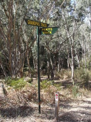
After a crazed rush down hill, I appeared on a bush track, and following it, I got to this junction. Appropriately, I had been walking on Pratt's track, but now I had reached my beloved Heysen Trail.
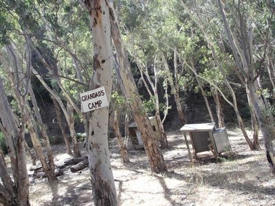
And lo and behold, here was a lovely little campground. Had I known that as I was walking, people were dreaming up the camping achievement, I almost certainly would have stayed here overnight, but instead I just stopped for a minute or two for a look around.
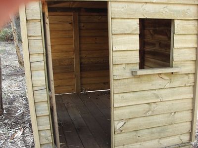
Not, it's not a Kubby House. This is an official Heysen Trail camping shelter. Most of them are a lot bigger than this, but maybe they were running out of money by this bit or something.
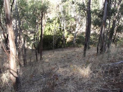
The view from the hash site, just 100 metres away from the campsite up a very slippery hill, especially for someone inappropriately attired like myself.
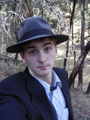
An owl at the hash. Looking silly, of course.
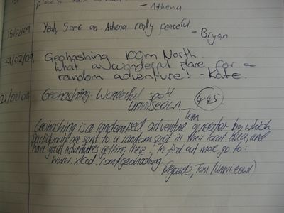
I've been to more than a dozen hashes, and never got even close to meeting another person at any of them. Imagine my suprise when I found a log by Kate in the logbook at the nearby campsite. Of course, this probably made me ineligible for the Saturday award, as I was there 45 minutes late, and somebody else could prove it, but I was pleased just to have been close, though I was kicking myself, as Kate had obviously found a more efficient route of reaching the hash than I had. So I signed the book, and wrote a nice little note for fellow bushwalkers about our wacky sport, in my spidery, illegible script, of course.
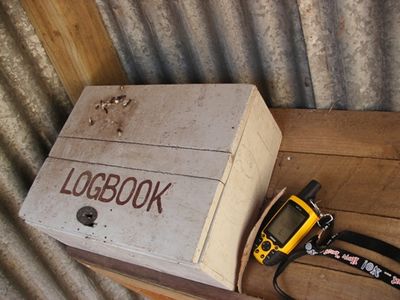
Having a logbook kinda makes it feel like a geocache, really.
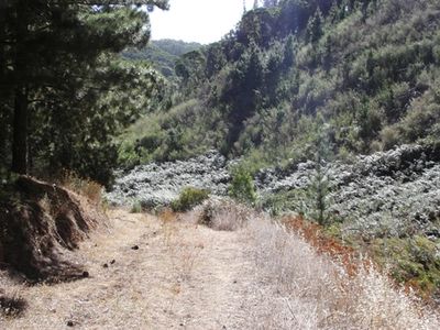
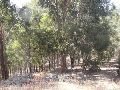
I decided to go back a different way, which was just as well, as I got to see this cool little valley full of ferns amongst the forest. The world is full of exciting little secret places, a drain, a campsite, a hidden valley, none of which I woudl ever have discovered if it weren't for geohashing.
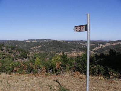
Steep (and it was). Unfortunately, this sign came a little too late for me. There was also a 'Track Impassable' one (It wasn't).
Back where I had been thinking of giving up, at the top of the hill. Satisfied from a fulfilling journey, I was very glad I hadn't taken this sign's advice when I'd first seen it.
Back at my car. Time to pull the prickles out of my suit and get back home.
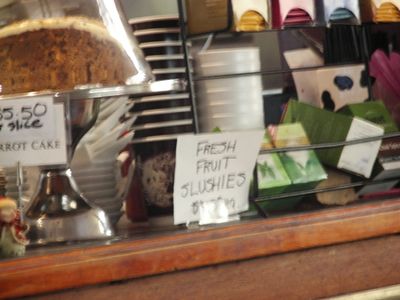
But not before a stop at the local cafe. And look, they had geoslushies!

I settled for a caramel milkshake and a line in the guest book. After this photo was taken I added my location as (the internet).
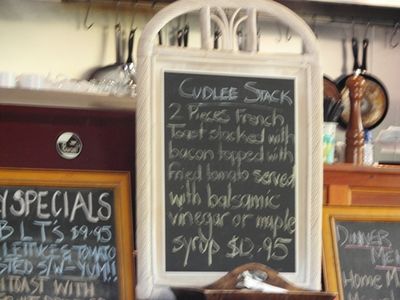
Kinda glad I was too full after my milkshake to contemplate a 'Cudlee Stack', although it does sound kind of tasty.
I was an hour too late to get hashcards :(

A map of what I did wrong. Mind you, google has no idea what is going on there either. That 'Cudlee Creek Road' doesn't exist at all, and Snake Gully Road doesn't go that far...Anyway, the red is the route of the Heysen trail, where I should have gone, the blue is where I did go, and the pink is me having fun scribbling on the map in MSPaint.


