Difference between revisions of "2009-02-21 47 11"
From Geohashing
imported>FippeBot m (Location) |
m (Replacing Peeron with Geohashing.info) |
||
| Line 9: | Line 9: | ||
On a path along the high-way, north-east of Bach. | On a path along the high-way, north-east of Bach. | ||
| − | + | {{egl|2009-02-21|47,11|text=Link to the location}} | |
Revision as of 20:41, 15 January 2022
| Sat 21 Feb 2009 in Bach: 47.8655206, 11.8235131 geohashing.info google osm bing/os kml crox |
About
On a path along the high-way, north-east of Bach.
Expeditions
Harleydavidsonandy
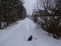
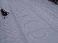
Visited this Hashpoint today by walking abt. 500m along the crowded high-way no. 8. Parked my car under a bridge. Without the high-way, this would be definitely a very nice area with some woods, little hills and - today - loads of snow. I was glad to find a tractor trace in the knee-deep snow, otherwise this would have been a very exhausting exercise. Could zero out between the track and the fence towards the high-way. Thank you for taking me out.
Final Destination
VERY close ;-)
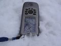
XKCD on ground zero
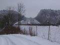
View to the high-way


Achievments
Harleydavidsonandy earned the Land geohash achievement
|