Difference between revisions of "2009-03-04 51 -1"
imported>Homsar (expedition!) |
imported>FippeBot m (Location) |
||
| (2 intermediate revisions by one other user not shown) | |||
| Line 19: | Line 19: | ||
Last night I discovered that today's hashpoint was INSIDE the Oxford ring road; thus easily accessible by bike. Not only that, but it also lay NOT in the middle of a field (rare in this graticule), and in fact seemed to be in a public place. Unfortunately, the day after my [[2009-02-08 51 -1|last attempt]] at a hash, the wheel fell off my bike - luckily it didn't happen a day before, otherwise I'd really have been up skit creek - but it meant that as I still haven't found a replacement nut, today's hash had to be walked to. Hummed and harred, but the beautiful weather this morning convinced me (no snow this time). | Last night I discovered that today's hashpoint was INSIDE the Oxford ring road; thus easily accessible by bike. Not only that, but it also lay NOT in the middle of a field (rare in this graticule), and in fact seemed to be in a public place. Unfortunately, the day after my [[2009-02-08 51 -1|last attempt]] at a hash, the wheel fell off my bike - luckily it didn't happen a day before, otherwise I'd really have been up skit creek - but it meant that as I still haven't found a replacement nut, today's hash had to be walked to. Hummed and harred, but the beautiful weather this morning convinced me (no snow this time). | ||
| − | Had a theoretical physics lecture at 10, finishing at 11, so I took a rucksack to that to keep my laptop in, and headed straight out from there. The route for the [[2009-02-08 51 -1|previous attempt]] took me almost to the hash point, but turning off onto Wood Farm Close instead of carrying on to the ring road. I arrived at about 12:06, an hour and 6 minutes-ish after leaving, which is exactly how long Google said it would take. Hashpoint was reasonably easy to locate, although an exact location was thwarted by teh wall in the way of seeing the garden that was visible in the aerial shot. (Still no GPS for me - in hindsight I think the hashpoint was in fact a metre or two to the right of me in the photos relative to the house. Still, circle of uncertainty!) Took some pictures (phone camera, because memory card for semi-decent camera has been mislaid), but didn't stop for long as it wasn't a terribly nice area, and there seemed to be a gang of youths in a nearby bus stop looking for either trouble or just something to do. Lack of nearby materials (and aforementioned youths) also prevented leaving any sign of my presence. Grabbed a Diet Coke and a Creme Egg in a nearby shop (I didn't have breakfast and neglected to pack a drink into the rucksack) and headed back to college for lunch. Roundtrip time: 2¼ hours. | + | Had a theoretical physics lecture at 10, finishing at 11, so I took a rucksack to that to keep my laptop in, and headed straight out from there. The route for the [[2009-02-08 51 -1|previous attempt]] took me almost to the hash point, but turning off onto Wood Farm Close instead of carrying on to the ring road. I arrived at about 12:06, an hour and 6 minutes-ish after leaving, which is exactly how long Google said it would take. Hashpoint was reasonably easy to locate, although an exact location was thwarted by teh wall in the way of seeing the garden that was visible in the aerial shot. (Still no GPS for me - in hindsight I think the hashpoint was in fact a metre or two to the right of me in the photos relative to the house. Still, circle of uncertainty!) Took some pictures (phone camera, because memory card for semi-decent camera has been mislaid), but didn't stop for long as it wasn't a terribly nice area, and there seemed to be a gang of youths in a nearby bus stop looking for either trouble or just something to do. Lack of nearby materials (and aforementioned youths) also prevented leaving any sign of my presence. Grabbed a Diet Coke and a Creme Egg in a nearby shop (I didn't have breakfast and neglected to pack a drink into the rucksack) and headed back to college for lunch. Roundtrip time: 2¼ hours. Distance walked: 10.8 km (5.3 there, 5.5 back) - 11.0 if you count the walk to the lecture too. Just falls short of the longest [[walk geohash]] achievement, sadly. Although my legs are reluctant to forgive me as it is! |
== Photos == | == Photos == | ||
| Line 26: | Line 26: | ||
Image:2009-03-04 51 -1 Map and house.jpg | The aerial photograph guided me to the hash point; the house confirmed the location | Image:2009-03-04 51 -1 Map and house.jpg | The aerial photograph guided me to the hash point; the house confirmed the location | ||
Image:2009-03-04 51 -1 Map and pitch.JPG | The aerial photograph again, and the pitch further confirmed the location | Image:2009-03-04 51 -1 Map and pitch.JPG | The aerial photograph again, and the pitch further confirmed the location | ||
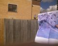
| − | Image:2009-03-04 51 -1 Ed and house. | + | Image:2009-03-04 51 -1 Ed and house.jpg | Me in front of the aforementioned house, looking unbelievably unattractive |
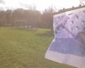
Image:2009-03-04 51 -1 Ed and pitch.JPG | Me in front of the aforementioned pitch, looking even worse. In my defense, it was incredibly bright (hence squinting), sufficiently so that I couldn't see the screen of my phone to see whether the picture was fugly or not. | Image:2009-03-04 51 -1 Ed and pitch.JPG | Me in front of the aforementioned pitch, looking even worse. In my defense, it was incredibly bright (hence squinting), sufficiently so that I couldn't see the screen of my phone to see whether the picture was fugly or not. | ||
| Line 37: | Line 37: | ||
[[Category:Coordinates reached]] | [[Category:Coordinates reached]] | ||
| + | {{location|GB|ENG|OXF}} | ||
Latest revision as of 02:08, 8 August 2019
| Wed 4 Mar 2009 in 51,-1: 51.7496004, -1.2004194 geohashing.info google osm bing/os kml crox |
Participants
Plans
- None were made. Useless.
Expedition
Last night I discovered that today's hashpoint was INSIDE the Oxford ring road; thus easily accessible by bike. Not only that, but it also lay NOT in the middle of a field (rare in this graticule), and in fact seemed to be in a public place. Unfortunately, the day after my last attempt at a hash, the wheel fell off my bike - luckily it didn't happen a day before, otherwise I'd really have been up skit creek - but it meant that as I still haven't found a replacement nut, today's hash had to be walked to. Hummed and harred, but the beautiful weather this morning convinced me (no snow this time).
Had a theoretical physics lecture at 10, finishing at 11, so I took a rucksack to that to keep my laptop in, and headed straight out from there. The route for the previous attempt took me almost to the hash point, but turning off onto Wood Farm Close instead of carrying on to the ring road. I arrived at about 12:06, an hour and 6 minutes-ish after leaving, which is exactly how long Google said it would take. Hashpoint was reasonably easy to locate, although an exact location was thwarted by teh wall in the way of seeing the garden that was visible in the aerial shot. (Still no GPS for me - in hindsight I think the hashpoint was in fact a metre or two to the right of me in the photos relative to the house. Still, circle of uncertainty!) Took some pictures (phone camera, because memory card for semi-decent camera has been mislaid), but didn't stop for long as it wasn't a terribly nice area, and there seemed to be a gang of youths in a nearby bus stop looking for either trouble or just something to do. Lack of nearby materials (and aforementioned youths) also prevented leaving any sign of my presence. Grabbed a Diet Coke and a Creme Egg in a nearby shop (I didn't have breakfast and neglected to pack a drink into the rucksack) and headed back to college for lunch. Roundtrip time: 2¼ hours. Distance walked: 10.8 km (5.3 there, 5.5 back) - 11.0 if you count the walk to the lecture too. Just falls short of the longest walk geohash achievement, sadly. Although my legs are reluctant to forgive me as it is!
Photos
The aerial photograph guided me to the hash point; the house confirmed the location
The aerial photograph again, and the pitch further confirmed the location

Me in front of the aforementioned house, looking unbelievably unattractive

Me in front of the aforementioned pitch, looking even worse. In my defense, it was incredibly bright (hence squinting), sufficiently so that I couldn't see the screen of my phone to see whether the picture was fugly or not.


