Difference between revisions of "2009-03-06 52 0"
imported>Benjw (Planned expedition) |
imported>FippeBot m (Location) |
||
| (3 intermediate revisions by one other user not shown) | |||
| Line 6: | Line 6: | ||
| graticule_link=Cambridge, United Kingdom | | graticule_link=Cambridge, United Kingdom | ||
}} | }} | ||
| − | == | + | == Location == |
| + | About 20m off a public footpath that runs round a field in Ashdon, Essex, in the south of the [[Cambridge, United Kingdom|graticule]], about 15 miles from Cambridge. This hashpoint is only 850m away from the hashpoint on [[2009-02-04 52 0|4 February]], which was successfully visited by [[User:Benjw|Benjw]]. Ben also visited today's hash. | ||
| − | + | == Participants == | |
| + | * [[User:Benjw|Benjw]] | ||
| − | + | == Expedition == | |
| + | [[2009-02-04 52 0|Last time I went to Ashdon]] I had set off from work, but today I was working on the other side of Cambridge, so I went home for lunch first. The route I took to get to Ashdon was exactly the same, though -- past the Bartlow Barrows I visited last time (I didn't stop there today) and over the Essex border in the same place. It was a bit less snowy, today, though! | ||
| − | + | Once in the village I took the first left turn instead of the second, and headed up the nearest road to the hashpoint. I had noticed a windmill on the map and satellite photos, but I was surprised to see that it was restored ten years ago, and is now carefully maintained by the Ashdon Windmill Trust. They have even provided a small carpark for visitors. I used it. As I got out the car I turned my GPSr on. Only 300m from the hashpoint! What luxury. (I spared a small thought for those struggling through Finnish snowfields or cursing their way through the Canadian bush on their way to hashpoints today.) | |
| − | [[Category: | + | As the hashpoint wasn't going anywhere, I had a look at the windmill first, but it was locked up (I discovered after returning home that it is only open to the public for one afternoon each month). Not much to see today, then, so the GPS came out again and I set off around the field on a public footpath. This got me about 20m away from the exact coordinates, and the last few metres were done through the mud. It had rained earlier in the week but I had no idea it was going to be quite so sticky. I left two inches taller than I arrived, I'm sure, with all the mud on my shoes. |
| + | |||
| + | The usual photos were taken and, it now being 4:50pm, I proceeded home before the traffic started to get too heavy. Not quite an Easy Geohash, but a nice straightforward expedition nonetheless. | ||
| + | |||
| + | == Shiny ribbons earned == | ||
| + | Just the one standard one this time. | ||
| + | |||
| + | {{land geohash | ||
| + | | latitude = 52 | ||
| + | | longitude = 0 | ||
| + | | date = 2009-03-06 | ||
| + | | name = [[User:Benjw|Benjw]] | ||
| + | }} | ||
| + | |||
| + | ==Photographic documentation== | ||
| + | <gallery> | ||
| + | Image:2009-03-06 52 0 essex.jpg | The Essex border. Compare with [[:Image:2009-02-04 essex.jpg|this photo]] taken a month earlier. | ||
| + | Image:2009-03-06 52 0 windmill.jpg | Bragg's Mill. You can see the moon above the top-left sail! | ||
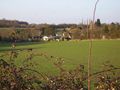
| + | Image:2009-03-06 52 0 hashpoint.jpg | Looking over to the hashpoint from the windmill steps. | ||
| + | Image:2009-03-06 52 0 gps.jpg | Proof of hash. | ||
| + | Image:2009-03-06 52 0 west.jpg | Looking west back towards the farmhouse and windmill. | ||
| + | Image:2009-03-06 52 0 south.jpg | Looking south. | ||
| + | Image:2009-03-06 52 0 north.jpg | Looking north over the hedge to nearby houses. | ||
| + | Image:2009-03-06 52 0 mud.jpg | The mud was very sticky! | ||
| + | </gallery> | ||
| + | |||
| + | [[Category:Expeditions]] | ||
| + | [[Category:Expeditions with photos]] | ||
| + | [[Category:Coordinates reached]] | ||
| + | {{location|GB|ENG|ESS}} | ||
Latest revision as of 02:10, 8 August 2019
| Fri 6 Mar 2009 in Cambridge: 52.0580113, 0.3296276 geohashing.info google osm bing/os kml crox |
Location
About 20m off a public footpath that runs round a field in Ashdon, Essex, in the south of the graticule, about 15 miles from Cambridge. This hashpoint is only 850m away from the hashpoint on 4 February, which was successfully visited by Benjw. Ben also visited today's hash.
Participants
Expedition
Last time I went to Ashdon I had set off from work, but today I was working on the other side of Cambridge, so I went home for lunch first. The route I took to get to Ashdon was exactly the same, though -- past the Bartlow Barrows I visited last time (I didn't stop there today) and over the Essex border in the same place. It was a bit less snowy, today, though!
Once in the village I took the first left turn instead of the second, and headed up the nearest road to the hashpoint. I had noticed a windmill on the map and satellite photos, but I was surprised to see that it was restored ten years ago, and is now carefully maintained by the Ashdon Windmill Trust. They have even provided a small carpark for visitors. I used it. As I got out the car I turned my GPSr on. Only 300m from the hashpoint! What luxury. (I spared a small thought for those struggling through Finnish snowfields or cursing their way through the Canadian bush on their way to hashpoints today.)
As the hashpoint wasn't going anywhere, I had a look at the windmill first, but it was locked up (I discovered after returning home that it is only open to the public for one afternoon each month). Not much to see today, then, so the GPS came out again and I set off around the field on a public footpath. This got me about 20m away from the exact coordinates, and the last few metres were done through the mud. It had rained earlier in the week but I had no idea it was going to be quite so sticky. I left two inches taller than I arrived, I'm sure, with all the mud on my shoes.
The usual photos were taken and, it now being 4:50pm, I proceeded home before the traffic started to get too heavy. Not quite an Easy Geohash, but a nice straightforward expedition nonetheless.
Shiny ribbons earned
Just the one standard one this time.
Benjw earned the Land geohash achievement
|
Photographic documentation
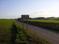
The Essex border. Compare with this photo taken a month earlier.
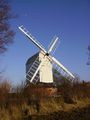
Bragg's Mill. You can see the moon above the top-left sail!
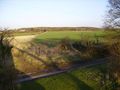
Looking over to the hashpoint from the windmill steps.
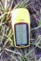
Proof of hash.
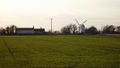
Looking west back towards the farmhouse and windmill.
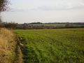
Looking south.
Looking north over the hedge to nearby houses.
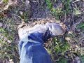
The mud was very sticky!


