Difference between revisions of "2009-03-09 52 -0"
imported>Joannac (i'm just a poor boy) |
|||
| Line 1: | Line 1: | ||
| − | + | {{meetup graticule | |
| − | to | + | | lat=52 |
| − | + | | lon=-0 | |
| − | + | | date=2009-03-09 | |
| − | + | | graticule_name=Northampton | |
| − | + | | graticule_link=Northampton, United Kingdom | |
| − | + | }} | |
| − | + | Today's hashpoint was just outside Peterborough, in a field that looks to be part of Norwood Farm. [[User:Benjw|Benjw]] found the hashpoint, the third one of a [[Multihash|Triple Hash]] expedition -- the other parts are [[2009-03-09 52 1|here]] and [[2009-03-09 52 0|here]]. | |
| − | + | ||
| − | + | == Expedition == | |
| − | + | === [[User:Benjw|Benjw]] === | |
| − | [ | + | |
| − | + | I set off from the [[2009-03-09 52 0|Cambridge hashpoint]] at about 4:45pm, but because I was crossing the prime meridian, didn't have too far to go to the next hashpoint -- only as far as Peterborough. The journey was easy and relatively dull -- along the A47 most of the way. | |
| + | |||
| + | There was a garden centre close to the nearest road access to the hashpoint, but they had a sign up preventing non-customers from parking in their carpark. I didn't feel like buying anything, and there was plenty of room on the road outside, so I parked there. The sun was setting as I walked past radio and mobile telephone masts on the way to the hashpoint, which made for a good photo. | ||
| + | |||
| + | The usual procedure for farm hashpoints seems to have become very familiar. Park car, walk along country lane, turn off onto track between fields, get as close as possible, then find the point in the field itself. Nothing was different here. There was nothing moving in the fields around me, in contrast to the roar of people driving home from work on the nearby A15 road around Peterborough. It was quite nice not to be doing that. | ||
| + | |||
| + | The hashpoint was reached and photos were taken of the proof and the view, such as it was. I headed back to the car. | ||
| + | |||
| + | Now, I had all sorts of grand plans about going on to other hashpoints after this one. I had enough time before midnight to get to four more, and I was pretty certain that at least three of them would be accessible. But sitting in the car at 5:40pm, eating an apple and drinking another cup of thermos tea, I had a sudden attack of being sensible. Driving around the country like a maniac and staying up until the wee small hours, just so I could visit a bunch of random points, ''didn't actually sound like much fun''. I'd had a splendid afternoon until then, but now I was getting tired and a little hungry, and felt like going home. | ||
| + | |||
| + | I think a big part of geohashing is knowing when to stop. There will always be other opportunities and other hashpoints to visit. And besides, it was getting dark. So I fed my apple core to some nearby horses, and drove home. I even did some grocery shopping on the way. | ||
| + | |||
| + | Total distance travelled for today's three geohashes -- 295km (185 miles). | ||
| + | |||
| + | == Shiny ribbons earned == | ||
| + | {{land geohash | ||
| + | | latitude = 52 | ||
| + | | longitude = -0 | ||
| + | | date = 2009-03-09 | ||
| + | | name = [[User:Benjw|Benjw]] | ||
| + | | image = 2009-03-09 52 -0 masts and sunset.jpg | ||
| + | }} | ||
| + | {{Multihash2 | ||
| + | | count = 3 | ||
| + | | date = 2009-03-09 | ||
| + | | name = [[User:Benjw|Benjw]] | ||
| + | }} | ||
| + | |||
| + | == Photographic documentation == | ||
| + | <gallery perrow="3"> | ||
| + | Image:2009-03-09 52 -0 garden centre.jpg | The garden centre where I didn't park the car. | ||
| + | Image:2009-03-09 52 -0 masts and sunset.jpg | The sun setting behind two comms masts. | ||
| + | Image:2009-03-09 52 -0 gps.jpg | Proof of hash. | ||
| + | Image:2009-03-09 52 -0 buildings.jpg | The edge of Peterborough, as seen from the hashpoint. | ||
| + | Image:2009-03-09 52 -0 horses.jpg | A nearby apple-core disposal facility. | ||
| + | </gallery> | ||
| + | |||
| + | [[Category:Expeditions]] | ||
| + | [[Category:Expeditions with photos]] | ||
| + | [[Category:Coordinates reached]] | ||
Revision as of 08:25, 10 June 2009
| Mon 9 Mar 2009 in Northampton: 52.6171403, -0.2402096 geohashing.info google osm bing/os kml crox |
Today's hashpoint was just outside Peterborough, in a field that looks to be part of Norwood Farm. Benjw found the hashpoint, the third one of a Triple Hash expedition -- the other parts are here and here.
Expedition
Benjw
I set off from the Cambridge hashpoint at about 4:45pm, but because I was crossing the prime meridian, didn't have too far to go to the next hashpoint -- only as far as Peterborough. The journey was easy and relatively dull -- along the A47 most of the way.
There was a garden centre close to the nearest road access to the hashpoint, but they had a sign up preventing non-customers from parking in their carpark. I didn't feel like buying anything, and there was plenty of room on the road outside, so I parked there. The sun was setting as I walked past radio and mobile telephone masts on the way to the hashpoint, which made for a good photo.
The usual procedure for farm hashpoints seems to have become very familiar. Park car, walk along country lane, turn off onto track between fields, get as close as possible, then find the point in the field itself. Nothing was different here. There was nothing moving in the fields around me, in contrast to the roar of people driving home from work on the nearby A15 road around Peterborough. It was quite nice not to be doing that.
The hashpoint was reached and photos were taken of the proof and the view, such as it was. I headed back to the car.
Now, I had all sorts of grand plans about going on to other hashpoints after this one. I had enough time before midnight to get to four more, and I was pretty certain that at least three of them would be accessible. But sitting in the car at 5:40pm, eating an apple and drinking another cup of thermos tea, I had a sudden attack of being sensible. Driving around the country like a maniac and staying up until the wee small hours, just so I could visit a bunch of random points, didn't actually sound like much fun. I'd had a splendid afternoon until then, but now I was getting tired and a little hungry, and felt like going home.
I think a big part of geohashing is knowing when to stop. There will always be other opportunities and other hashpoints to visit. And besides, it was getting dark. So I fed my apple core to some nearby horses, and drove home. I even did some grocery shopping on the way.
Total distance travelled for today's three geohashes -- 295km (185 miles).
Shiny ribbons earned
Benjw earned the Land geohash achievement
|
Benjw earned the Multihash Achievement
|
Photographic documentation
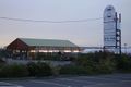
The garden centre where I didn't park the car.
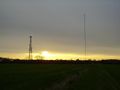
The sun setting behind two comms masts.
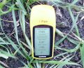
Proof of hash.
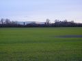
The edge of Peterborough, as seen from the hashpoint.
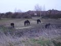
A nearby apple-core disposal facility.


