Difference between revisions of "2009-03-09 52 1"
imported>Benjw (report to follow) |
imported>Benjw (expedition write-up) |
||
| Line 6: | Line 6: | ||
| graticule_link=Norwich, United Kingdom | | graticule_link=Norwich, United Kingdom | ||
}} | }} | ||
| − | [[User:Benjw|Benjw]] | + | Today's hashpoint was just outside Norwich, in woodland owned by the University of East Anglia (UEA), north of Cringleford. [[:Image:2009-03-09 52 1 sign.jpg|Permission is given]] to pedestrians (with well-behaved dogs) to walk through the woodland. Despite lack of dog, [[User:Benjw|Benjw]] found the hashpoint, on the first recorded expedition in this graticule. |
| + | |||
| + | This was the first part of a [[Multihash|Triple Hash]] expedition by Ben -- the other parts are [[2009-03-09 52 0|here]] and [[2009-03-09 52 -0|here]]. | ||
| + | |||
| + | == Expedition == | ||
| + | === [[User:Benjw|Benjw]] === | ||
| + | |||
| + | I'd finished everything I needed to do at work by 11:15, so I went home. I made some lunch, did some washing up, answered some emails and did some maths homework, but soon the call of the geohash was too strong. I succumbed, and printed off maps, made a flask of tea and some sandwiches, and was out of the door at 1:30pm. | ||
| + | |||
| + | I had grand plans for reaching many hashpoints today, so decided to take a relatively long trip to Norwich to start off with. It's a fair distance, but there's a reasonable main road that goes straight there. As expected the journey was slow in the single-carriageway sections, but it wasn't too bad overall and soon I had parked up in the village of Cringleford. I walked to the edge of the village, not knowing quite what to expect when I got to the woodland -- there was a pathway through it to the UEA campus but whether the rest was open to the public or not, I didn't know. | ||
| + | |||
| + | Luckily, it was. A large sign at the gate said that use of the woodland without authorisation was fine for pedestrians with well-behaved dogs. Unfortunately I hadn't brought any well-behaved dogs with me. I looked around but I couldn't see a single one that I might be able to borrow. Still, nobody was looking so I sneaked in without one. | ||
| + | |||
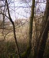
| + | A path led in the general direction I wanted to go, so I followed it until about 200m from the hashpoint, when it went elsewhere, so I walked through the trees for the last bit. This was not as awkward as other expedition reports from more forested parts of the world have made it sound -- here the woods were quite airy and not at all overgrown. A few minutes later I found the hashpoint -- right next to a path! Evidently I could have taken the easy route after all. | ||
| + | |||
| + | Despite having a few people put their names on the wiki, this was the first recorded expedition in the graticule. I was pleased that it was so easily successful, and in quite a pleasant spot. I hereby claim the Virgin Graticule award for [[52,1]]. | ||
| + | |||
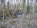
| + | A few metres further north of the hashpoint the ground got rather marshy as it approached the river. I could see the UEA buildings through the trees but didn't get as far as the river itself as I started to sink into the mud. Good job the hashpoint itself wasn't a few metres further north! | ||
| + | |||
| + | It was then almost exactly 3:00pm. After taking a few photos, I returned (through the trees again) to the car, and set off on my [[2009-03-09 52 0|next expedition]]. | ||
| + | |||
| + | == Shiny ribbons earned == | ||
| + | {{land geohash | ||
| + | | latitude = 52 | ||
| + | | longitude = 1 | ||
| + | | date = 2009-03-09 | ||
| + | | name = [[User:Benjw|Benjw]] | ||
| + | | image = 2009-03-09 52 1 ben.jpg | ||
| + | }} | ||
| + | {{Virgin graticule | ||
| + | | latitude = 52 | ||
| + | | longitude = 1 | ||
| + | | date = 2009-03-09 | ||
| + | | name = [[User:Benjw|Benjw]] | ||
| + | | image = 2009-03-09 52 1 ben.jpg | ||
| + | }} | ||
| + | |||
| + | == Photographic documentation == | ||
| + | <gallery perrow="4"> | ||
| + | Image:2009-03-09 52 1 sign.jpg | Permission to go geohashing (even though I didn't have a dog). | ||
| + | Image:2009-03-09 52 1 ben.jpg | Ben at the hashpoint. | ||
| + | Image:2009-03-09 52 1 gps.jpg | GPS proof that the point was reached. | ||
| + | Image:2009-03-09 52 1 swamp.jpg | Luckily the hashpoint didn't fall just a few metres north. | ||
| + | Image:2009-03-09 52 1 reeds.jpg | Marshy ground between the river and the hashpoint. | ||
| + | Image:2009-03-09 52 1 university.jpg | University of East Anglia (UEA) buildings through the trees. | ||
| + | </gallery> | ||
[[Category:Expeditions]] | [[Category:Expeditions]] | ||
[[Category:Expeditions with photos]] | [[Category:Expeditions with photos]] | ||
[[Category:Coordinates reached]] | [[Category:Coordinates reached]] | ||
Revision as of 17:18, 10 March 2009
| Mon 9 Mar 2009 in Norwich: 52.6171403, 1.2402096 geohashing.info google osm bing/os kml crox |
Today's hashpoint was just outside Norwich, in woodland owned by the University of East Anglia (UEA), north of Cringleford. Permission is given to pedestrians (with well-behaved dogs) to walk through the woodland. Despite lack of dog, Benjw found the hashpoint, on the first recorded expedition in this graticule.
This was the first part of a Triple Hash expedition by Ben -- the other parts are here and here.
Expedition
Benjw
I'd finished everything I needed to do at work by 11:15, so I went home. I made some lunch, did some washing up, answered some emails and did some maths homework, but soon the call of the geohash was too strong. I succumbed, and printed off maps, made a flask of tea and some sandwiches, and was out of the door at 1:30pm.
I had grand plans for reaching many hashpoints today, so decided to take a relatively long trip to Norwich to start off with. It's a fair distance, but there's a reasonable main road that goes straight there. As expected the journey was slow in the single-carriageway sections, but it wasn't too bad overall and soon I had parked up in the village of Cringleford. I walked to the edge of the village, not knowing quite what to expect when I got to the woodland -- there was a pathway through it to the UEA campus but whether the rest was open to the public or not, I didn't know.
Luckily, it was. A large sign at the gate said that use of the woodland without authorisation was fine for pedestrians with well-behaved dogs. Unfortunately I hadn't brought any well-behaved dogs with me. I looked around but I couldn't see a single one that I might be able to borrow. Still, nobody was looking so I sneaked in without one.
A path led in the general direction I wanted to go, so I followed it until about 200m from the hashpoint, when it went elsewhere, so I walked through the trees for the last bit. This was not as awkward as other expedition reports from more forested parts of the world have made it sound -- here the woods were quite airy and not at all overgrown. A few minutes later I found the hashpoint -- right next to a path! Evidently I could have taken the easy route after all.
Despite having a few people put their names on the wiki, this was the first recorded expedition in the graticule. I was pleased that it was so easily successful, and in quite a pleasant spot. I hereby claim the Virgin Graticule award for 52,1.
A few metres further north of the hashpoint the ground got rather marshy as it approached the river. I could see the UEA buildings through the trees but didn't get as far as the river itself as I started to sink into the mud. Good job the hashpoint itself wasn't a few metres further north!
It was then almost exactly 3:00pm. After taking a few photos, I returned (through the trees again) to the car, and set off on my next expedition.
Shiny ribbons earned
Benjw earned the Land geohash achievement
|
Photographic documentation
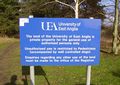
Permission to go geohashing (even though I didn't have a dog).
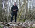
Ben at the hashpoint.
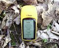
GPS proof that the point was reached.
Luckily the hashpoint didn't fall just a few metres north.
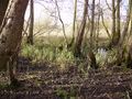
Marshy ground between the river and the hashpoint.
University of East Anglia (UEA) buildings through the trees.


