Difference between revisions of "2009-03-19 67 22"
From Geohashing
imported>FippeBot m (Location) |
m |
||
| Line 17: | Line 17: | ||
| − | {{Virgin graticule | latitude = 67 | longitude = 22 | date = 2009-03-19 | name = [[User:the_ru | the ru]] | + | {{Virgin graticule | latitude = 67 | longitude = 22 | date = 2009-03-19 | name = [[User:the_ru | the ru]]}} |
<gallery perrow="3"> | <gallery perrow="3"> | ||
Image:2009-03-19_67_22_snow.jpg | Suspicious snow formation | Image:2009-03-19_67_22_snow.jpg | Suspicious snow formation | ||
| − | |||
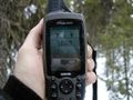
Image:2009-03-19_67_22_gps.jpg | | Image:2009-03-19_67_22_gps.jpg | | ||
Image:2009-03-19_67_22_pinecone.jpg | Pinecone | Image:2009-03-19_67_22_pinecone.jpg | Pinecone | ||
Revision as of 00:42, 29 November 2023
| Thu 19 Mar 2009 in 67,22: 67.3593302, 22.2229452 geohashing.info google osm bing/os kml crox |
The hashpoint was in the forest near Saittarova, 300 m from the road.
the ru
I was extremely bored at work and had to get away for a while.
A friend of mine has relatives in 67 22 so I was already familiar with the area and the route I had to take. We went skiing not far from the hashpoint no more than a week ago. The trip went smoothly, I passed through Svappavaara, Vittangi, Masugnsbyn and a couple of other villages.
I had very poor grip with my skiis, but since it was such a short distance I didn't bother to apply any wax.
This was my first expedition in the Pajala municipality.
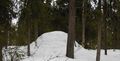
Suspicious snow formation
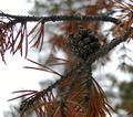
Pinecone
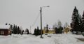
Central Masugnsbyn


