Difference between revisions of "2009-03-23 52 0"
imported>Benjw (Monday's geohash -- right in someone's garden) |
imported>FippeBot m (Location) |
||
| (6 intermediate revisions by one other user not shown) | |||
| Line 6: | Line 6: | ||
| graticule_link=Cambridge, United Kingdom | | graticule_link=Cambridge, United Kingdom | ||
}} | }} | ||
| − | + | == Location == | |
| + | At the side of a house in Hauxton village, just south of Cambridge. | ||
| − | [[Category: | + | == Participants == |
| + | * [[User:Benjw|Benjw]] | ||
| + | * MrsBenjw (who sat in the car and refused to be part of this) | ||
| + | |||
| + | == Plans == | ||
| + | Benjw had intended this to be a walk geohash of about 9km each way from his house in Cambridge, but in the end was taken out to dinner, so made a quick stop by car on the way to that instead. | ||
| + | |||
| + | == Expedition == | ||
| + | We drove out from Cambridge in the early evening, and since I knew Hauxton village quite well we had no trouble locating the house where the hash had fallen. MrsBenjw decided that she would rather just sit in the car, so I got out and knocked on the door, ready to ask if I could photograph some random stranger's back garden. | ||
| + | |||
| + | However, nobody was at home, so after waiting some time just to be sure, I poked my head around the side of the house and took a photo of the general area of the hashpoint. I walked up to the gate to the back garden, at which point the GPS read 3.65m to go. I didn't want to open the gate and charge into their back garden without permission, so I didn't go any further, but I noticed when I got back to the car that the GPS accuracy was hovering around 4m. So... ''did I get the geohash or not?'' | ||
| + | |||
| + | Pondering that question, we drove on to an excellent Thai restaurant, where I was treated to a superb meal because it wasn't my birthday. All expeditions should end like this. | ||
| + | |||
| + | (Footnote -- Afterwards, I noticed that the Google aerial view of this hash shows it as next to the side of the house, and not in the back garden at all. On that basis, coupled with the fact that I ''was'' within the circle of error of my GPS, I am claiming the hash as reached.) | ||
| + | |||
| + | == Photographic evidence == | ||
| + | <gallery> | ||
| + | Image:2009-03-23 52 0 house.jpg | The first time I've had to ring someone's doorbell and explain geohashing. | ||
| + | Image:2009-03-23 52 0 hashpoint.jpg | But they weren't in! <phew> I took a quick photo down the side of the house. | ||
| + | Image:2009-03-23 52 0 gps.jpg | And this is as near as I got. | ||
| + | </gallery> | ||
| + | |||
| + | [[Category:Expeditions]] | ||
| + | [[Category:Expeditions with photos]] | ||
| + | [[Category:Coordinates reached]] | ||
| + | {{location|GB|ENG|CAM}} | ||
Latest revision as of 02:26, 8 August 2019
| Mon 23 Mar 2009 in Cambridge: 52.1444640, 0.1049863 geohashing.info google osm bing/os kml crox |
Location
At the side of a house in Hauxton village, just south of Cambridge.
Participants
- Benjw
- MrsBenjw (who sat in the car and refused to be part of this)
Plans
Benjw had intended this to be a walk geohash of about 9km each way from his house in Cambridge, but in the end was taken out to dinner, so made a quick stop by car on the way to that instead.
Expedition
We drove out from Cambridge in the early evening, and since I knew Hauxton village quite well we had no trouble locating the house where the hash had fallen. MrsBenjw decided that she would rather just sit in the car, so I got out and knocked on the door, ready to ask if I could photograph some random stranger's back garden.
However, nobody was at home, so after waiting some time just to be sure, I poked my head around the side of the house and took a photo of the general area of the hashpoint. I walked up to the gate to the back garden, at which point the GPS read 3.65m to go. I didn't want to open the gate and charge into their back garden without permission, so I didn't go any further, but I noticed when I got back to the car that the GPS accuracy was hovering around 4m. So... did I get the geohash or not?
Pondering that question, we drove on to an excellent Thai restaurant, where I was treated to a superb meal because it wasn't my birthday. All expeditions should end like this.
(Footnote -- Afterwards, I noticed that the Google aerial view of this hash shows it as next to the side of the house, and not in the back garden at all. On that basis, coupled with the fact that I was within the circle of error of my GPS, I am claiming the hash as reached.)
Photographic evidence

The first time I've had to ring someone's doorbell and explain geohashing.
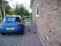
But they weren't in! <phew> I took a quick photo down the side of the house.
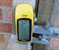
And this is as near as I got.


