Difference between revisions of "2009-04-08 49 -123"
imported>Rhonda (→Rhonda) |
(Almost there) |
||
| Line 69: | Line 69: | ||
===Continuing upwind against the tide=== | ===Continuing upwind against the tide=== | ||
| + | The last three kilometres were the worst, except for the last two, which were really the worst. Rhonda would call out an encouraging number like "Two point five kilometres to go!" and we would duck against the wind and paddle steadily for several minutes. Robyn counted strokes as a way to pass the time, lost track of what number she ws on a couple of times and then saw Rhonda check the GPS again. Maybe we were coming up on two kilometres to go? "Two point four kilometres!" Rhonda announced. Nooooo! All that paddling and we had gone a hundred metres. I'm not sure we were getting fifteen centimetres of forward progress for every paddle stroke. | ||
| + | |||
| + | Robyn couldn't believe it. She got out her own GPS again. It matched Rhonda's, now 2.39 km remaining. Another eon passed before it showed a little over one kilometre left. And it also indicated that a significant right turn was required to the geohash. Robyn's compass was at home on the coffee table, so the direction arrow on the GPS would have to do, but it was pretty steadily indication the need for a turn to the right. On making that turn it centred. And then, travelling across the wind instead of into it, and with a ones digit on the display, the metres flew by. Nine hundred. Eight hundred. Seven-fifty. | ||
===Reaching the geohash=== | ===Reaching the geohash=== | ||
Revision as of 00:48, 10 April 2009
| Wed 8 Apr 2009 in Vancouver: 49.5051543, -123.2894917 geohashing.info google osm bing/os kml crox |
The Vancouver graticule just got a whole lot more accessible.
Planning
Robyn
Robyn has been working on a project to demonstrate the general inaccessibility of geohashes in the Vancouver graticule. Each morning she looks up the geohash and tries to calculate how long it would take her to reach it. Problem is that in order to calculate how long it would take, you have to figure out how you would get there. And once you have done that, you have a plan. And plans just beg to be implemented.
Today's installment of the "my graticule is insane" chronicles noted a point in the middle of Howe Sound, just over two kilometres from the Squamish Highway and more than six kilometres north or south of the nearest access points to the water. (The shore in between is a cliff dropping straight from the highway into the water.) Dutifully Robyn typed in these details, initially estimating 5 km/h for a kayak, but then dropping it to 3 km/h because of unfavourable tides and winds, thus two hours to reach the point, plus driving and kayak set up time. Remember that Robyn owns an inflatable kayak, which she bought yesterday and has not yet removed from the original packaging. Also the weather forecast called for rain.
Robyn, somehow believing that four hours in a kayak she just bought would not be so bad, or perhaps in a fit of bravado, announced her intentions to try the day's geohash. Rhonda promptly contacted Robyn to say she would rent a kayak, and did she have a roof rack? Robyn didn't, and assumed that Rhonda would soon figure out that Robyn was crazy and would wait for a slightly normal geohash. Rhonda, however, is at least as insane as Robyn. Every graticule gets the geohashers it deserves. While Robyn was about ten minutes away from Porteau Cove, Rhonda called to let her know that she was coming. "Great!" said Robyn. Or possibly just "Oh." She meant "Great," but was stunned that someone else would do this. "I'll be the one inflating a kayak," said Robyn.
Rhonda
Rhonda just discovered geohashing a week before, the day of gale force winds over the hash point, and had been waiting for something possible. So when Robyn announced her plans for trying the Anvil Island hash point, Rhonda immediately went looking for kayak rentals.
Unfortunately, places that rent kayaks do not also rent roof racks to carry them on. The rental place that delivered kayaks to your launch point started to offer, until she said "Porteau Cove". "Oh." Silence. "Well, call us back if you find some roof racks then."
At this point, the easiest option was to find out if Robyn had roof racks. Sadly, the easy option did not pan out. Robyn suggested that Rhonda contact another local geohasher, Thepiguy, who had a van which had carried kayaks before. Sadly, that option did not pan out either, as he was stuck indoors all day.
Rhonda did not actually want to buy roof racks, but went looking for a set that would fit her car. After a bit of searching, she found out that roof racks were, minimum, about half the cost of the inflatable kayak that Robyn had linked to on her user page, and suddenly between that and the cost of rental, buying an inflatable kayak became a reasonable idea. Add in the convenience of not trying to arrange a same-day rental and pickup, and it became a good idea. A trip to Canada's biggest toy store followed, and with the help of a store manager quite willing to cut packages open (and surprised that this purchase was for a same day trip) she collected kayak, pump with the (confirmed) correct attachment, paddle, and lifejacket, going through the checkout 1h4m before scheduled to meet Robyn at Porteau Cove.
After a quick stop at home to make something portable for lunch and enter the co-ordinates into her GPS, she hit the highway and called Robyn to let her know that she would in fact be there. Robyn sounded flabbergasted (and happy) to receive that message.
Participants
Expedition
Getting Ready

Rhonda parked right beside Robyn's very easy to spot car, in a vehicle that very notably did not have roof racks, nor a kayak on the roof. Robyn had been watching for a rooftop kayak and so didn't recognize Rhonda as a fellow geohasher until Rhonda waved while stopping, and Robyn could see the newly familiar shape of a Sevylar inflatable kayak in Rhonda's car.
After the usual introductions ("Hi! Are you from the internet?") both kayaks were inflated and rigged with only occasional reference to the owner's manuals and a small struggle when trying to install a cross brace after inflation when the manual said it was easiest to install before inflation. The manual was right.
Robyn and Rhonda organized GPSs, cameras, water, and snacks into pockets and kayak cargo bags, while T-Rex claimed a position on the bow of Robyn's kayak, holding on to the cargo straps. There was some discussion of optimal launch points and whether it would be faster to walk the kayaks across a rocky, barnacle-encrusted beach to launch a little bit closer to the hash point, or launch at the closest point to the cars. In the end, Rhonda pointed out that there was an actual boat launch and they agreed that would be easier on both ankles and inflatables. Rhonda tucked her camera into the very clever little pocket on the side of her lifejacket for easy access while on the water.
Wearing bright red lifejackets and bright yellow spray skirts, they picked up the kayaks by their convenient carry handles and walked across the parking lot and down the boat ramp. Rhonda was totally right about ease of launch. Robyn, who didn't have proper kayak footwear, managed to board and launch without even getting her feet wet.
Launch
At the boat launch, a random stranger with a power boat admired the brand new, bright yellow kayaks. He was pretty impressed to hear that they were inflatable, because they don't actually look like inflatable pool toys until you get close enough to see that they have a fabric hull. Then they just don't look like pool toys.
Robyn got her kayak launched first, and paddled around in circles at the end of the boat launch to practise steering and control while Rhonda tried to get her spray skirt to stay on.
"This is the most comfortable kayak I've ever been in!" Robyn called to shore, where Rhonda was finally settled in and trying to push the kayak off the pavement without scraping the bottom too much.
They determined the official launch time as 2:20PM and ducked under the never used Emergency Ferry Terminal to start the trip to the south end of Anvil Island.
Upwind against the tide
At first it was exhilarating. The kayaks floated. They stayed right side up. They went in a straight line. They were very comfortable. (Think about it: the entire kayak is an air mattress.) With the two kayaks side by side it was easy to chat and discuss strategy. "So do you think go over to the island and along the shore and then to the point or just straight for the point?" In further proof of the observation that you go wherever your attention is directed, conversations were periodically punctuated by kayak collisions and attempts to paddle apart without hitting the other with the paddle, while silences had no collisions.
As they paddled out of the cove, the headwind became apparent, and bands of water ahead showed different textures, implying more or less wind and different directions of current, but lacking sufficient knowledge of the local area to choose a most efficient indirect route, just going for it seemed the best course. The decision was straight for the point. In as much as one goes straight for anything in a small craft, in wind, waves and tide.
The kayaks climbed the waves like champs, even when whitecaps broke over the bow. T-Rex must have swallowed some salt water because he was a little green, but he didn't drown. He wasn't, however, doing his share of the paddling, and Robyn blames his added weight and wind resistance for her falling behind Rhonda. It was a good vantage point to see the size of the waves. They were coming straight towards the bows and when Rhonda was in a trough one wave ahead, Robyn could only see her head, not her body or kayak.
Rhonda had a wrist-mounted GPS which she could consult without putting down her paddle. Robyn's was around her neck, and required a free hand to look at, and Robyn was worried that its water resistance might not extend to sitting in the puddle of seawater that was forming on top of the spray skirt, so she put hers away to follow Rhonda. Every time Rhonda stopped paddling for a short rest, or to let Robyn catch up, her GPS insisted they were going the wrong way. And they probably were, because as soon as either kayaker stopped paddling, the wind and waves would turn the kayak sideways. But the intrepid duo persevered.
Upwind some more against the tide
After what seemed like a really adequately adventurous period of time, Rhonda announced five kilometres. Not we had gone five kilometres, but that we had five kilometres left to go. It was a little discouraging. But it was such a glorious day. Rain threatened, but it was not yet raining, so it wasn't too hot even with exertion. Despite the water everywhere, (yes, everywhere) it wasn't too cold. The highway was visible along the cliff to the left. Perhaps the passengers in the cars could see us and wondered what two kayaks were doing way out here in the sea. Most likely the drivers were concentrating too hard on the treacherous road to look out and see. To the right was Anvil Island,
In a relatively quiet band with little wind, Rhonda put some extra effort into her paddling to pull ahead, so she could take a picture of Robyn. She popped her spray skirt up and found her water, snacks, and gloves, but no camera. After a bit of searching inside the kayak, she shrugged and figured either it had slid behind the seat while launching or she had left it in the car, then paddled hard to catch up to Robyn who had noticed the extra effort, mistaken it for encouragement, by way of a demonstration of how much faster she could be going, also put in extra effort and passed her while she was distracted.
Continuing upwind against the tide
The last three kilometres were the worst, except for the last two, which were really the worst. Rhonda would call out an encouraging number like "Two point five kilometres to go!" and we would duck against the wind and paddle steadily for several minutes. Robyn counted strokes as a way to pass the time, lost track of what number she ws on a couple of times and then saw Rhonda check the GPS again. Maybe we were coming up on two kilometres to go? "Two point four kilometres!" Rhonda announced. Nooooo! All that paddling and we had gone a hundred metres. I'm not sure we were getting fifteen centimetres of forward progress for every paddle stroke.
Robyn couldn't believe it. She got out her own GPS again. It matched Rhonda's, now 2.39 km remaining. Another eon passed before it showed a little over one kilometre left. And it also indicated that a significant right turn was required to the geohash. Robyn's compass was at home on the coffee table, so the direction arrow on the GPS would have to do, but it was pretty steadily indication the need for a turn to the right. On making that turn it centred. And then, travelling across the wind instead of into it, and with a ones digit on the display, the metres flew by. Nine hundred. Eight hundred. Seven-fifty.
Reaching the geohash
At 998m remaining, Robyn announced that she had just done better than her previous expedition, where she was forced to stop 999m from the hash point. The wind was quieter here, and both kayakers zig-zagged and circled, trying to find the hash point when they started drifting and turning in the wind and current as soon as they stopped paddling. "Forward," to the GPS, was not necessarily toward the pointy end of the kayak.
While searching, Rhonda heard a blow-hole sort of sound, and turned to look, spotting a flat patch of water nearby amid the ripples, with a few bubbles floating on it.
Finally, Robyn took a picture with under 3m to go and an accuracy of 3m on her GPS.
Rhonda's GPS showed 9.74km travelled from where she told it to start recording, under the unused ferry dock, and 3h28m elapsed. She had also been sitting in water for a while, which she assumed was from the rear cargo hatch cover that she'd been unable to seal properly, and she was really hoping she had forgotten her camera in the car.
Returning upwind against the tide
Celebration and photography complete, Robyn glanced at her watch. "It's six o' clock!" she exclaimed. Notwithstanding the issue about it having taken three and a half hours to reach and celebrate the point, the tide was about to turn the other way. It's just not fair to have to paddle both ways against the tide. As there was nothing anyone could do about it, Robyn bit her tongue and didn't mention the other thing she had noticed about Howe Sound weather this time of the afternoon. Maybe if she didn't say it, it wouldn't happen.
Rhonda, however, didn't need anyone to tell her such things, "Hey, the wind is blowing the wrong way!" Geohashing is not T-ball. "Fair" is not part of the sport. The wind was certainly not as strong as it had been outbound, but it was in our faces again. It did become less and less over the two hours it took to return to the dock. The last two kilometres were in ideal kayaking conditions: gentle ripples on calm water. The vortices from Rhonda's paddle were still visible swirling in the sea as Robyn followed in her trail, maybe 30 metres behind, and the kayaks left visible wakes. The seal seemed to have followed us, popping up behind Rhonda's kayak and then again right next to Robyn's, exerting itself a little in order to get a higher vantage point on these new creatures in its environment. It stayed above water just long enough for Robyn not to take a picture of it.
Ahead, Rhonda stopped paddling and let her kayak drift for a few minutes while she watched an eagle flap by overhead. Perhaps the passage of our kayaks was affecting the fish in a way that made our locus interesting to piscavores, or maybe animals like to watch us, just the way we like to watch them. There must be enough kayaks in these waters that the seals have figured out that the little pointy boats pose no threat. There were also saw seagulls too numerous to mention and some dark ducks flying rapidly in ground effect over the water.
The daylight faded, especially to the eyes of fatigued kayakers wearing dark sunglasses, and the emergency ferry dock plus a few vehicles became visible in the distance at Porteau Cove. After paddling under the ferry dock and around the breakwater, Rhonda said "Boat dock!" After five and a half hours of paddling, Robyn was so grateful to see that boat dock, it is likely that in future those words will escape her lips at moments of ecstasy. "Boat dock!"
It feels so good to get out of a kayak and walk, after that long. It was five minutes to eight.
Deflation and Home
Reported Winds
The winds record for the period, observed by Environment Canada at Pam Rocks near Anvil Island are shown in the following table:
| Time | Winds from | Kayak bearing |
|---|---|---|
| 15:00 | SSW 15 | SSW |
| 16:00 | S 19 | SSW |
| 17:00 | S 15 | SSW |
| 18:00 | S 7 | turning around |
| 19:00 | NW 3 | N |
| 20:00 | NNW 6 | Done! |
We did it. We are very tired. More details to come.
Lessons Learned
- Shoes don't fit in kayaks very well.
- Tie the spray skirt around your chest, not your waist, or you end up with a puddle in your lap.
- The Sevylor Pointer K1 inflatable kayak is awesome.
- Eat a snack before you're about to pass out from hunger.
- Double-check the drain valves before launching.
Highlights

- easy to inflate
- seal followed us
- eagle
- we got told we looked hot
- wind
- waves
- tide
- five and a half hours in an inflatable kayak
- 9.74km from launch to hash point. Slightly shorter on the return trip.
- Average speed against wind and wave: 2.8km/hr
- we have declared Sevylor the official kayak of the Vancouver graticule
Gallery
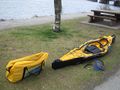
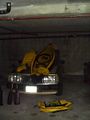
A kayak before application of the air pump
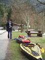
Robyn and the kayaks
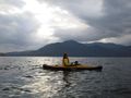
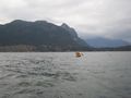
Rhonda circling, looking for the geohash
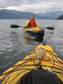
The two kayaks together at the geohash
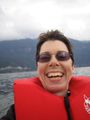
Robyn displaying the traditional geohashing stupid grin
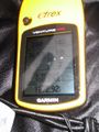
Proof of our arrival at the point
Anvil Island, rising behind Rhonda
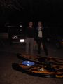
Night fell before we had finished deflating the kayaks.
Hey, the bottom comes out! (drying off at home)


We would have more intermediate photographs but the waves in the middle made it not a good idea to get out cameras.