2009-04-16 48 -122
| Thu 16 Apr 2009 in Bellingham: 48.9657078, -122.8002113 geohashing.info google osm bing/os kml crox |
Contents
Location
Today's Bellingham, Washington graticule geohash was on the Birch Point peninsula in Semiahmoo Bay, very close to the Canadian border. It appeared to be just off the end of a side road from Semiahmoo Drive, but trees in the satellite view blocked knowledge of exactly what was there.
Planning Spontaneity
Planning consisted of thepiguy telling Robyn she should come with him for the border hash, because he'd never done one before, Rhonda saying she'd come too, and everyone trying to explain where to meet in a riot of edit conflicts. See the talk page for more details. Everything else we made up on the fly.
Partcipants
In order of being recruited for the mission:
Expedition
Rhonda
I knew I had to catch the 10:30AM Seabus if I wanted to join the others at the Peace Arch at 1PM, so I scrambled to get my stuff together (chores? bah!), pumped up the tires on my bike since it hadn't been ridden for a few months, and ran out the door.

A block from home, I found out that my bike's brakes desperately need to be replaced. As I careened toward 1st St., I gave thanks that I was on a quiet road and made a hard left so my brakes were only working against my forward momentum and not gravity as well. (For those who don't know, the altitude change from 1st St. to 2nd St. in North Vancouver is equivalent to two stories in a building.) With a mental note to replace the brakes tomorrow and also to start braking well in advance, I continued toward the Seabus.
Because busses can only carry two bikes, I opted to catch the 351 at its terminus station instead of the station closest to the seabus - only a couple of blocks farther.
My GPS, which had faithfully recorded my route from inside the Seabus, complained about a weak signal inside the bus, so I sat with my arm against the window. Also that way I could keep an eye on my bike, on its rack on the front of the bus.
The bus headed through downtown, keeping its schedule faithfully, as recorded by the Translink auditor sitting across from me with his clipboard, chatting with the driver about the absurd prices demanded by scalpers for hockey tickets.
At one of the stops, I recognized Robyn out front with her bike just as the bus opened its doors, and collected my stuff off the seat beside me so she and T-Rex could sit there.
thepiguy
thepiguy set out at 11:00 on the dot, and then again at 11:15 once he turned around went back to his house to pick up a few items he forgot.

He took all his usual bike routes and uttered a small curse at translink for forcing him to take a bus through the tunnel. Once in Ladner he began following the cycling directions he had figured out in the morning. Being an extremely intelligent adventurer idiot he didn't actually bring them with him and had to figured out where to go by memory. He kept trying to take the most obvious and direct route to the border (i.e. the highway) but kept getting turned back by every cyclists favorite road sign.
By the time he was speeding down the gigantic hill on the highway, everything was going great, but by the time he was trundling up the giant hill in White Rock he was very behind schedule. He kept passing bus stops and thinking of Robyn and Rhonda hoping that since he had been nice and said he'd wait for them, they'd do the same and wouldn't leave without him.
Once he finally made it to the designated meeting spot he decided to promptly collapse.
Robyn
I put off packing for my mission that might start tomorrow, hastily cleaned my kitchen, grabbed my passport and headed for the border. Vancouver is bisected by the mighty Fraser River, which can be crossed by numerous bridges, a ferry or a tunnel, but the last, while the most convenient way across for my route, is off limits to bicycles. I didn't want to take the time to go around the long way, where I always get stuck in the mud on an unpaved bike route in Surrey, so I rode out to Granville Street to wait for the 351 bus, which would take me to within 30 blocks of the border.
It's always a little suspenseful waiting for a bus with a bicycle. The buses have bike racks, but each bus can take only two bikes, so if two other people have decided to take bikes on the bus that day, you're out of luck. The 601 came with an empty bike rack and I wondered if I should get on it instead, and go to the Ladner Exchange. Fortunately the 351 arrived with only one bike on it, so I didn't have to figure that out. And the one bike was Rhonda's, so all was well.
All
Border
After photographing the Peace Arch and wandering around and reading all the commemorative monuments (commemorating the border being unfortified, the surveyors doing a good job figuring out where the border was (although it wasn't quite at 49N by our GPSes), Canada and the US not having had a war since 1814, and more stuff like that) Rhonda and Robyn noticed another cyclist approaching. He rode down the southbound road, veered across the traffic lanes onto the grass of the park and then dropped the bike and collapsed supine in front of the Peace Arch, gasping, "White Rock ... is .. uphill."

Robyn stood back to watch another line on the Meetup Graph form, waiting for one to ask the other if they were from the Internet, but Rhonda just watched to make sure thepiguy didn't need immediate medical attention and no one remembered to take a picture. Everyone got back on the bikes and followed Robyn past the lines of cars waiting to cross the border, between the spaces in a barricade marked Road Closed - No Entry, around the corner of a building through a collection of disused, rusting border gates and what may have been old Christmas decorations. Just when they were starting to believe that Robyn's 'experience' at crossing the the border was really experience at sneaking past the border without clearing customs, she stopped at a door labelled "Pedestrian Entrance."
Unfortunately the effect was kind of ruined by the fact that the door was locked. They'd changed the usable entrance door to another one, behind the building. Inside, there was a velvet roped area for queuing with a sign saying "enter here" but no one in the queue. Robyn entered where the sign said, but instead of going all the way through the velvet ropes and back, just went around the other side of the sign to the front of the line. The others were just starting to tell her that she was doing it wrong, when an agent at the other side of the room said we could come to her. This necessitated everyone climbing over, under or around the velvet ropes, so no one knew who was doing it wrong any more, and we just handed over our passports.
Robyn was still playing the role of "person in this expedition who knows what is going on" so she answered the questions.
"Where are you going?"
"Semiahmoo Bay."
"Just out for a bike ride?"
"We're members of an adventure club, and today our meeting location is out there."
"Adventure Club, hmm, what are you going to do?"
"Play games, meet whoever else is there ... last week we went kayaking."
The trick is, you don't have to persuade the people at the border that you are sane, just that you aren't going to try and blow anything up. She gave us our passports back and we looked at the pictures to figure out who was who. She also gave us an orange post-it with the letter A written on the back. Robyn knew what this was for, so took it and all went back out to the bikes.
Behind the building, on the south, i.e. American, side, there are a number of parking spots where the people who are 'randomly' selected for car searches park. And there are officers out there. Robyn gave one of the officers the orange post-it, saying, "Presumably "A" means, 'Please let these three people pass'." The officer didn't let on that Robyn had cracked the secret code, merely took the post-it and allowed the trio to pass.
I wonder what letter we'd have got if there were four of us.
Riding to the hash point
By this point we had determined that no one had brought written directions to the geohash, but everyone remembered a little bit of how to get there, and honestly, how hard is to find a point on the west coast of the mainland. You just go south and keep taking the road by the sea. That's what we did.
We rode south on Peace Portal Way, a quiet road beside the sea. It was a little disquieting that signs kept giving a mileage countdown to when the road was going to turn into an I-5 on-ramp, but before we found out whether we were going to be forced onto the interstate, we found a right turn signed for Birch Point and took it. From then on we luxuriated in the fact that there were no ferries to catch, no hundred kilometres to bike before dark, no rain, just a really pleasant bike ride by the sea. Every time the road bifurcated we took the fork closest to the sea. As we headed out on to the peninsula we were riding right next to the beach, looking out across the water to Canada.
We found and followed Something Harbor Road, which Rhonda remembered from the directions. We went up a hill. ("Hey, Robyn, you said there were no hills!") It was more exciting than going up one of the many hills of the Sunshine Coast because it was not one of dozens of hills in a hundred kilometre stretch, and because we were now entering the last few kilometres before the geohash. The stage where you start looking at the sides of the road to see what you are going to have to contend with in the last few metres, after you leave the road. Omens were mixed. In some places there was a wide verge beside the road, even a multi-use path. We passed a golf course (but we knew the geohash wasn't on it). We also passed gated communities with huge foreboding walls and locked gates. It would be quite the ambassador achievement to get past such a barricade.

Within a kilometre of the geohash, Robyn crossed from the road to the multi-use path, but the GPS direction needle swung around to indicate we were abeam the geohash yet over a kilometre away. What? Was it through this hedge.
Now it was Rhonda's turn to remember some of the directions. "The road will come around and come back," he promised. We rode on, staying a kilometre away for some time, as the road curved around the peninsula and started back the other way. And finally the GPS counted down. Nine hundred, eight hundred, seven hundred fifty. Robyn loves this part. It's so suspenseful. Rhonda calls out that the geohash will be up ahead, at the end of a little road that will help us get closer. We take the turn 130 metres from the point. The road looks just about that long. Thepiguy goes ahead, Robyn still calling off distances, "eighty ... sixty ... thirty." The road is ending less than thirty metres ahead, but the GPS needle no longer points straight ahead. "Turn left!" says Robyn.
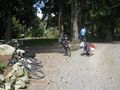
Left is a driveway, gravel and lined with trees and flowers. And there we dismounted to perform the traditional GPS dance to the hash point.
Celebrating success
Blaine, WA

Border, take 2
Heading home
- Detour to Canada
- clearing at the car lane
thepiguy
As his fellow geohashers waited for their bus, thepiguy sped down the hill out of White Rock , enjoying himself while he could, since he knew there was an even bigger and steeper hill waiting for him up ahead. He made it back to the bus stop to catch a bus through the tunnel and managed to pick the only bus that didn't actually go through the tunnel. Getting off at the first stop he crossed the road and managed to catch the same bus in the opposite direction back to the original bus stop and catch the proper bus back into Richmond.
The rest of the ride was uneventful, except for the Raptor that jumped out of the bushes and he was turning a corner on a gravel road. It managed to get a hold of his hand on force him into a spectacular dirt-in-mouth landing. There were a few small Raptor wounds, but mostly just a lot of dirt.
Photos
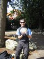
The money shot.
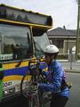
Bikes on buses made this hash a lot easier (for 2/3 of the expedition)
Robyn and her bike
Lineup? What lineup?
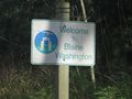
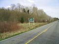
Welcome sign!
Not following the sign. Not.
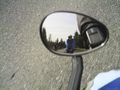
thepiguy multitasking.
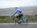
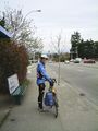
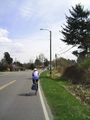
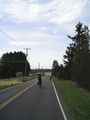
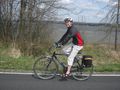
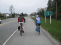
Robyn on the way to the hash
And also Rhonda on the way to the hash.
We all made it to the geohash and immediately got to work.
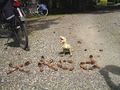
xkcd marks the spot.
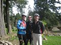
A happy group of hashers!
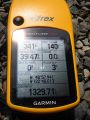
The obligatory GPS shot.
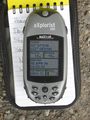
And thepiguy's gps too.
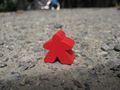
thepiguy's new hashscot: Murray the Meeple!
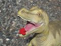
T-rex and Murray meet for the first time.
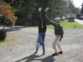
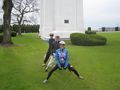
Robyn decided to start practicing for her Circus Geohash
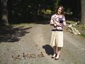
Kristy!
It was a pretty place.
Somehow Rhonda ended up in the lead.
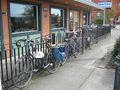
Our bikes waited for us outside while we went in to eat.
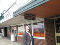
Rhonda outside the Mexican restaurant where we got lunch.
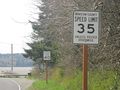
Explain to me what the point of that first sign is?
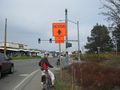
Possibly the greatest sign I have ever seen!
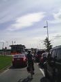
Everyone at the border on the way back.
The gang cycling back through White Rock.
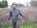
The aftermath of a Raptor attack.


