Difference between revisions of "2009-04-18 49 -122"
imported>Elbie (→Photographs: unmixed photos, added GPS shot) |
imported>Elbie (→Photographs: more photos) |
||
| Line 35: | Line 35: | ||
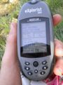
Image:2009-04-18 49 -122 coordinates.jpg | Successfully there! | Image:2009-04-18 49 -122 coordinates.jpg | Successfully there! | ||
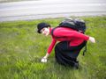
Image:Image-2009-04-18 49 -122 marking.jpg | Our marking at the coordinates. | Image:Image-2009-04-18 49 -122 marking.jpg | Our marking at the coordinates. | ||
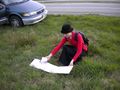
| + | Image:2009-04-18 49 -122 thepiguy marking.jpg | Thepiguy taking a photo of this. | ||
Image:2009-04-18_49_-122_elbie_pi_formal.jpg | Elbie and thepiguy at the hash. | Image:2009-04-18_49_-122_elbie_pi_formal.jpg | Elbie and thepiguy at the hash. | ||
Image:2009-04-18 49 -122 picnic.jpg | We picnicked! | Image:2009-04-18 49 -122 picnic.jpg | We picnicked! | ||
Image:2009-04-18 49 -122 elbie eating.jpg | Elbie enjoys some wine and cheese. | Image:2009-04-18 49 -122 elbie eating.jpg | Elbie enjoys some wine and cheese. | ||
| + | Image:2009-04-18 49 -122 geotrash1.jpg | Picking up trash. | ||
| + | Image:2009-04-18 49 -122 geotrash2.jpg | And some more. | ||
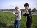
| + | Image:2009-04-18 49 -122 robyn xore.jpg | Robyn and Xore. | ||
</gallery> | </gallery> | ||
Revision as of 18:40, 18 April 2009
| Sat 18 Apr 2009 in 49,-122: 49.0845888, -122.8377370 geohashing.info google osm bing/os kml crox |
Location
On the side of Highway 99 just before it meets up with King George.
Participants
- thepiguy is determined to make a double hash along with the Vancouver/Nanaimo coordinates.
- Elbie wants a quality break from studying differential equations.
- Robyn wants to make this work out somehow with the Vancouver graticule geohash.
- Xore needs some fresh air.
Planning
Ironically enough, the main problem with the geohash being on the highway is accessibility! As thepiguy learned on his way to this hash this section of the highway is off-limits to cyclist, there may also be restrictions about stopping on the shoulder since it's such a major road. It's too accessible!
That being said, thepiguy doesn't care. He's going to take the geohashingmobile in the morning and visit the hash. If need be he'll pretend he's having car troubles, or that a hub cap flew off.
- Wait! I've got it! I'll pretend that I stopped to try and figure out my GPS and that I think it made me take a wrong turn! People are always getting confused by technology!
All I have to do is drive down the highway and stop at the right spot. There's a small bridge right before the hash, so assuming I'm traveling the speed limit (or something close) the hash should be 10 seconds after the bridge.
Xore is thinking of taking the 321 bus to the south surrey park and ride, then walking ~1km to the geohash point. Since he doesn't have a GPS device, he's going to try to triangulate position based on trees from google maps aerial, dashed lines on the highway, etc, going for batteryless geohash
Expedition
Writeup pending.
Photographs
Successfully there!
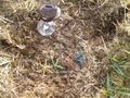
Our marking at the coordinates.
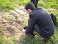
Thepiguy taking a photo of this.

Elbie and thepiguy at the hash.
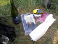
We picnicked!

Elbie enjoys some wine and cheese.
Picking up trash.
And some more.
Robyn and Xore.


