Difference between revisions of "2009-04-25 49 -123"
imported>Robyn (I love geohashing!) |
imported>Wade m (Add section) |
||
| Line 22: | Line 22: | ||
It was warmer once we got off the bike. | It was warmer once we got off the bike. | ||
| + | |||
| + | ===Wade=== | ||
| + | editing... | ||
===Rhonda=== | ===Rhonda=== | ||
Revision as of 21:49, 26 April 2009
| Sat 25 Apr 2009 in 49,-123: 49.4809778, -123.3527699 geohashing.info google osm bing/os kml crox |
Glorious, fabulous success. One of the most fun geohashes ever. Write-up tomorrow. Unless Rhonda does it. -Robyn
Contents
Location
Today's location was just up a hill behind Camp Artaban, on Gambier Island. By Vancouver standards, this location is highly accessible - and Wade wanted to see Camp Artaban and neither Rhonda nor Robyn wanted to get on their bikes for the Victoria hash point.
Planning
Robyn and Wade identified five possibilities for getting to the hash point, then settled on taking the scheduled water taxi from Horseshoe Bay, which had a stop at the government dock right at Camp Artaban, followed by a tour of the camp (since they had permission from a camp director to do so) and a short hike to the hash point, followed by whatever random hiking there was time for while waiting for the water taxi's afternoon visit.
Expedition
Robyn & Wade
We would have taken public transit to Horseshoe Bay, but we had an appointment at seven, and the bus didn't look as if it could get us home until eight, so we opted to drive Wade's motorcycle to the dock. There was little traffic on a Saturday morning so we zipped down the highway in less time than budgeted. Robyn sat on the back of the bike with T-Rex on her lap, and sang a song to herself about the scenery, temperature and company. It went approximately, "Cold cold cold cold, tree tree tree tree, cold cold, road road, Wade Wade Wade, cold cold cold, DIN-O-SAUR!"
It was warmer once we got off the bike.
Wade
editing...
Rhonda
I caught the bus to Horseshoe Bay, a thoroughly uneventful trip except for the huge number of cyclists on Marine Drive in West Vancouver - a street which is busy, narrow, twisty, has no shoulder to speak of, and yet is an inexplicably common cycling route. Maybe the other roads are worse.
When I got off the bus at the stop that seemed nearest the government docks, which I assumed were in the water visible from the corner, a lady with a fishing rod strapped to her backpack put it down on the sidewalk to adjust something.
"Going fishing?" I asked, searching for a conversation starter. It made as much sense as people asking Robyn if she knew she had a dinosaur on her bike, so why not?
"Yes, we're going to Gambier Island," the lady replied.
I told her I was also going to Gambier Island, and asked if she was taking the water taxi.
She was. "Do you know where they dock?" she asked.
"At the government dock, over there I think," I said, waving vaguely in the direction of the water I had seen when the bus turned the corner.
"We'll follow you then!" she said with a smile, as she swung her pack up to her shoulders.
Uh-oh.
She and her fishing companion didn't follow me far, once they saw the water, saying something about meeting friends and waving. "See you later!"
I walked on alone, looking for a public dock and scanning the area for Robyn, since I didn't know what Wade looked like other than from Robyn's pictures of him with his motorcycle helmet on, when I heard them call to me from somewhere behind me.
Camp Artaban
We walked down the dock to join the other people waiting for the scheduled water taxi, and two of them appeared shortly before 10AM, as scheduled. One called out the names of various bays on the island, and we confirmed that the bays he named included Camp Artaban before boarding.
The boat pulled away from the dock with nobody in the driver's seat inside the cabin, and we looked out to see a second control station behind the entrance, probably with better visibility. T-Rex wanted to pilot the boat for a while, and climbed onto the drivers seat until the captain came down inside the cabin.
It was really fun riding on the water taxi. It was just a boat, but it was the perfect size to take on the waves without bouncing, but still be right down on the water. You could ride inside on padded seats, like on a bus, or you could stand up on the uncovered deck at the stern and ride there. At each stop we pulled in and people very quickly jumped off, usually without the boat even mooring to the dock. It was more fun and chaotic than a regular ferry.
Camp Artaban was the third stop for the taxi, and we were the only ones for the stop, and the last ones off the boat. We confirmed with the captain that the earliest the return boat would be at the dock to pick us up would be 5:30 and that they would expect us there, and then we walked along the dock to look for the camp caretaker's house, with Robyn, who had attended summer camp here as a child, pointing out the features familiar and changed along the way, like the swimming tank which didn't used to have a diving board and the completely rebuilt boathouse in exactly the same spot as the remembered decrepit one.
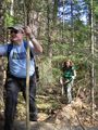
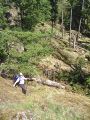
After securing permission to roam from the caretaker, we wandered up past the outdoor chapel, the dining hall and the campers' cabins. We kept walking along a rough road that continued beyond the cabins. We knew the geohash wasn't far, and that we had hours to find it, so there was no hurry, but for every bit the trail turned away from the geohash, it would turn back towards it more after a short time. By the time anyone asked, "so how are we doing?" we were inside a hundred metres from our goal. Robyn said, "The geohash is fifty-seven metres that way," pointing up a cliff. She looked kind of surprised when the others didn't immediately rush to climb it. Isn't 57 m a very short Stupidity Distance? Robyn was convinced the cliff was climbable, but went along with the others, who believed that following the trail a bit further would lead to where the map contour lines showed that the route to the geohash was not quite so steep. They were right. (Robyn was right too, but we'll get to that later).
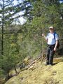
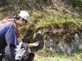
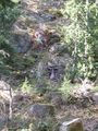
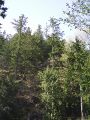
The "road" we were following was probably a skidder trail. It went quite steeply uphill itself, but we turned from there to a hands and feet scramble through light brush and over rocks and fallen trees, following a compass bearing. Robyn was in the lead, walking along a fallen tree and then climbing over another to find herself on the top of the cliffs we'd looked at from below. It was a sunny open area on slightly sloped moss-covered rocks. The geohash was 17 metres away.
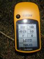
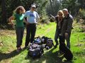
Robyn counted off the steps, walking along the edge to the corner of the cliff. She set down the GPS and grinned with enthusiasm, hardly able to wait for the others to see the reading on the GPS, but not wanting to spoil the surprise.
Celebrating success

More hiking
Return to the hashpoint for 4PM
Back to Horseshoe Bay
Photos
Feel free to move these inline with the report.
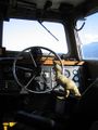
T-Rex steering us out of the harbour
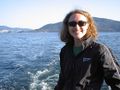
Rhonda riding in the open part of the water taxi
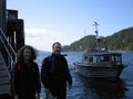
The water taxi backing out after dropping us off
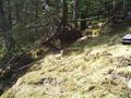
Going along a tree to get to the geohash
But we got there
Good thing it wasn't any further
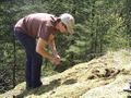
Creating the xkcd marker
T-rex and the marker, camouflaged
Chalk mark the spot
Climbing down from the hashpoint
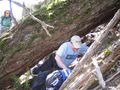
Going under a tree to get back down from the geohash
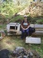
An outdoor living room!
Going straight up a cliff back to the geoashe
Where's Robyn? Back at the hashpoint for 4PM
But another group arrived at the base.
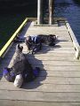
Waiting for the water taxi at the end of the day


