Difference between revisions of "2009-05-05 -41 174"
imported>Tjm1983 (Added graticule name and link, participants, plans, and some of expedition) |
m (per Renaming Proposal) |
||
| (13 intermediate revisions by 2 users not shown) | |||
| Line 1: | Line 1: | ||
<!-- If you did not specify these parameters in the template, please substitute appropriate things for IMAGE, LAT, LON, and DATE (YYYY-MM-DD format) --> | <!-- If you did not specify these parameters in the template, please substitute appropriate things for IMAGE, LAT, LON, and DATE (YYYY-MM-DD format) --> | ||
| − | [[Image: | + | [[Image:2009-05-05 -41 174 juggling2.jpeg|thumb|left]] |
{{meetup graticule | {{meetup graticule | ||
| lat=-41 | | lat=-41 | ||
| Line 20: | Line 20: | ||
This was my first attempt since [[2008-09-22 -41 174]]. I've now obtained a [http://openmoko.com/product.html Neo Freerunner], but we decided to try for a [[No Batteries Geohash]] anyway, based on maps and local knowledge. Since it was so close, we carried a camera and tripod, too. | This was my first attempt since [[2008-09-22 -41 174]]. I've now obtained a [http://openmoko.com/product.html Neo Freerunner], but we decided to try for a [[No Batteries Geohash]] anyway, based on maps and local knowledge. Since it was so close, we carried a camera and tripod, too. | ||
| − | We stood around discussing where exactly the hashpoint might be, chose a spot, and took enough photos for a complete panorama. Then, I turned on the Freerunner to see how close we were. About 14 metres. Is that close enough for a no-batteries success? | + | We stood around discussing where exactly the hashpoint might be, chose a spot, and took enough photos for a complete panorama. The ninja also took a photo of me juggling. Then, I turned on the Freerunner to see how close we were. About 14 metres. Is that close enough for a no-batteries success? |
| + | |||
| + | I walked back down the hill a little, till the Freerunner was oscillating between 0 metres and about 3 metres. The ninja took a photo of me at the right spot, I planted a sign there, and took a photo of it. On the way home, I took a few more photos, and kept a tracklog of part of the journey back. At home, the Freerunner indicated we were about 475m from the hashpoint, but it reckoned we'd walked about three times that far. | ||
== Tracklog == | == Tracklog == | ||
| − | + | [http://openstreetmap.org/user/tjm1983/traces/377925 Tracklog at openstreetmap.org] (shows only the track (no background map), but you can download a gpx file, if you want) | |
== Photos == | == Photos == | ||
<gallery perrow="3"> | <gallery perrow="3"> | ||
| − | Image:2009- | + | Image:2009-05-05 -41 174 trig.jpeg| A trig-point (geographical survey marker) near the hash-point |
| − | Image:2009- | + | Image:2009-05-05 -41 174 panorama.jpeg| A panorama |
| + | Image:2009-05-05 -41 174 juggling2.jpeg| Juggling | ||
| + | Image:2009-05-05 -41 174 screenshot1.png| Only 14 metres away! | ||
| + | Image:2009-05-05 -41 174 screenshot2.png| It said 0.000 a moment ago, honest! | ||
| + | Image:2009-05-05 -41 174 waving.jpeg| Waving from the real hashpoint (taken without moving the tripod or zooming in) | ||
| + | Image:2009-05-05 -41 174 marker.jpeg| The whole internet. All of it. | ||
| + | Image:2009-05-05 -41 174 old house.jpeg| For the first 20 years of my life, I lived in a house near the centre of this photo, also close enough for a Couch Potato Honourable Mention | ||
</gallery> | </gallery> | ||
| + | |||
| + | ==Ribbons== | ||
| + | {{land geohash | ||
| + | | latitude = -41 | ||
| + | | longitude = 174 | ||
| + | | date = 2009-05-05 | ||
| + | | name = [[User:tjm1983|tjm1983]] | ||
| + | | image = 2009-05-05 -41 174 waving.jpeg | ||
| + | }} | ||
| + | {{couch potato geohash | latitude = -41 | longitude = 174 | date = 2009-05-05 | name = [[User:tjm1983|tjm1983]] | honor = true }} | ||
| + | {{Walk geohash | ||
| + | | latitude = -41 | ||
| + | | longitude = 174 | ||
| + | | date = 2009-05-05 | ||
| + | | name = [[User:tjm1983|tjm1983]] | ||
| + | }} | ||
| + | {{Graticule unlocked | ||
| + | | latitude = -41 | ||
| + | | longitude = 174 | ||
| + | | date = 2009-05-05 | ||
| + | | name = [[User:tjm1983|tjm1983]] | ||
| + | }} | ||
| + | {{Circus geohash | ||
| + | | latitude = -41 | ||
| + | | longitude = 174 | ||
| + | | date = 2009-05-05 | ||
| + | | name = [[User:tjm1983|tjm1983]] | ||
| + | | image = 2009-05-05 -41 174 juggling2.jpeg | ||
| + | | performance = juggling | ||
| + | }} | ||
| + | {{No batteries geohash | ||
| + | | latitude = -41 | ||
| + | | longitude = 174 | ||
| + | | date = 2009-05-05 | ||
| + | | name = [[User:tjm1983|tjm1983]] | ||
| + | }} | ||
| + | |||
<!-- Potential categories. Please include all the ones appropriate to your expedition --> | <!-- Potential categories. Please include all the ones appropriate to your expedition --> | ||
| Line 37: | Line 82: | ||
--> | --> | ||
| − | |||
| − | |||
| − | |||
[[Category:Expeditions]] | [[Category:Expeditions]] | ||
[[Category:Expeditions with photos]] | [[Category:Expeditions with photos]] | ||
| − | |||
| − | |||
| − | |||
| − | |||
[[Category:Coordinates reached]] | [[Category:Coordinates reached]] | ||
| − | |||
<!-- or if you failed :( | <!-- or if you failed :( | ||
| Line 58: | Line 95: | ||
[[Category:Failed - Did not attempt]] | [[Category:Failed - Did not attempt]] | ||
--> | --> | ||
| + | {{location|NZ|WGN}} | ||
Latest revision as of 06:32, 20 March 2024

| Tue 5 May 2009 in Wellington: -41.2081079, 174.9413996 geohashing.info google osm bing/os kml crox |
Participants
tjm1983 and a Ninja Geohasher who helpfully took some photos
Plans
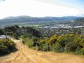
After many long months, watching this mostly-water graticule, I was surprised to discover a hashpoint apparently in Lower Hutt, where I live. My hopes rose. I zoomed in. The hashpoint looked like it wasn't just in Lower Hutt, it was actually close to where I live. My hopes rose. I zoomed in more. It really was close to where I live, and might even be on a residential street somewhere. My hopes rose. I zoomed in more. It was on a hill, not a residential street. Those hills are covered in prickly gorse. My hopes fell. I zoomed in more. It was right next to a firebreak on the hill, not far above where the firebreak joins a residential street. I've walked past it several times before. My hopes rose. I started re-reading the Achievements, deciding how many I could plausibly get. A Couch Potato Hono(u)rable Mention seemed likely, for a start.
Expedition
This was my first attempt since 2008-09-22 -41 174. I've now obtained a Neo Freerunner, but we decided to try for a No Batteries Geohash anyway, based on maps and local knowledge. Since it was so close, we carried a camera and tripod, too.
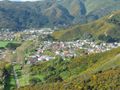
We stood around discussing where exactly the hashpoint might be, chose a spot, and took enough photos for a complete panorama. The ninja also took a photo of me juggling. Then, I turned on the Freerunner to see how close we were. About 14 metres. Is that close enough for a no-batteries success?
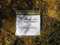
I walked back down the hill a little, till the Freerunner was oscillating between 0 metres and about 3 metres. The ninja took a photo of me at the right spot, I planted a sign there, and took a photo of it. On the way home, I took a few more photos, and kept a tracklog of part of the journey back. At home, the Freerunner indicated we were about 475m from the hashpoint, but it reckoned we'd walked about three times that far.
Tracklog
Tracklog at openstreetmap.org (shows only the track (no background map), but you can download a gpx file, if you want)
Photos
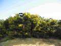
A trig-point (geographical survey marker) near the hash-point
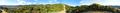
A panorama

Juggling
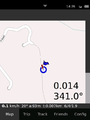
Only 14 metres away!
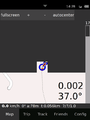
It said 0.000 a moment ago, honest!
Waving from the real hashpoint (taken without moving the tripod or zooming in)
The whole internet. All of it.
For the first 20 years of my life, I lived in a house near the centre of this photo, also close enough for a Couch Potato Honourable Mention


Ribbons
tjm1983 earned the Land geohash achievement
|

tjm1983 earned the Walk geohash Achievement
|
tjm1983 earned the Graticule Unlocked Achievement
|
tjm1983 earned the Circus Geohash Achievement
|
tjm1983 earned the No Batteries Geohash Achievement
|