Difference between revisions of "2009-05-11 39 -88"
From Geohashing
imported>Excellentdude (True baptism into geohashing. Template. Extensive photos and details to come.) |
imported>Excellentdude m (Track log...kind of...) |
||
| Line 22: | Line 22: | ||
== Photos == | == Photos == | ||
| + | === My Best Imitation of a Track Log === | ||
<gallery perrow="4"> | <gallery perrow="4"> | ||
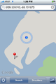
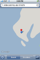
| + | Image:2009-05-11 39 -88 1201 Where I Was Going.PNG|Google directions take you to the nearest road to the hash... | ||
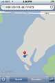
| + | Image:2009-05-11 39 -88 1202 Where I Should Have Been Going.PNG|...which isn't always where you want to go | ||
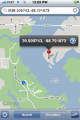
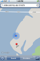
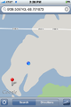
| + | Image:2009-05-11 39 -88 1303 Aroung the Inlet.PNG|I made it around the inlet! The rest should be easy! | ||
| + | Image:2009-05-11 39 -88 1321 Progressing Down Shoreline.PNG|Slowly progressing near the shoreline | ||
| + | Image:2009-05-11 39 -88 1326 Hmmm.PNG|Wait a minute! | ||
| + | Image:2009-05-11 39 -88 1327 A Little More Correct.PNG|OK, that makes more sense | ||
| + | Image:2009-05-11 39 -88 1345 Getting Closer.PNG|Getting closer... | ||
| + | Image:2009-05-11 39 -88 1351 And Closer.PNG|...and closer... | ||
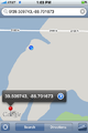
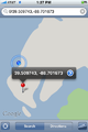
| + | Image:2009-05-11 39 -88 1404 Think I Made It 1.PNG|I think I made it | ||
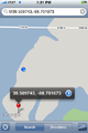
| + | Image:2009-05-11 39 -88 1405 Think I Made It 2.PNG|Things aren't matching, but I think I made it | ||
| + | Image:2009-05-11 39 -88 1406 Think I Made It 3.PNG|Zoomed out for similar perspective to others | ||
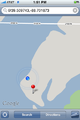
| + | Image:2009-05-11 39 -88 1428 On the Way Back.PNG|On the way back, trying to find a better path inland | ||
</gallery> | </gallery> | ||
Revision as of 16:17, 19 May 2009
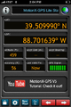
| Mon 11 May 2009 in Decatur: 39.5097432, -88.7016731 geohashing.info google osm bing/os kml crox |
About
Expedition
excellentdude: Although this was my twentieth geohashing expedition, this was clearly my baptism in geohashing, far surpassing my most difficult previous expedition which was probably 2009-03-09 38 -91. Extensive photos and details to come.
Achievements
excellentdude earned the Land geohash achievement
|
Photos
My Best Imitation of a Track Log
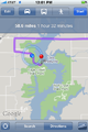
Google directions take you to the nearest road to the hash...
...which isn't always where you want to go
I made it around the inlet! The rest should be easy!
Slowly progressing near the shoreline
Wait a minute!
OK, that makes more sense
Getting closer...
...and closer...
I think I made it
Things aren't matching, but I think I made it
Zoomed out for similar perspective to others
On the way back, trying to find a better path inland


