Difference between revisions of "2009-05-21 52 13"
imported>Lyx m (New page: {{subst:expedition}}) |
m |
||
| (3 intermediate revisions by 2 users not shown) | |||
| Line 1: | Line 1: | ||
| − | |||
| − | |||
<!-- | <!-- | ||
[[Image:{{{image|IMAGE}}}|thumb|left]] | [[Image:{{{image|IMAGE}}}|thumb|left]] | ||
--> | --> | ||
{{meetup graticule | {{meetup graticule | ||
| − | | lat= | + | | lat=52 |
| − | | lon= | + | | lon=13 |
| − | | date= | + | | date=2009-05-21 |
}} | }} | ||
<!-- edit as necessary --> | <!-- edit as necessary --> | ||
__NOTOC__ | __NOTOC__ | ||
| + | == About == | ||
| + | |||
| + | The hash is located in a lake called Langer See (Long Lake), about 120m from shore. | ||
| + | |||
== Participants == | == Participants == | ||
| + | * [[User:lyx|lyx]], dragging along hir bike and boat | ||
== Plans == | == Plans == | ||
| + | * see if there is a place to launch a rubber boat | ||
| + | * under certain circumstances, launch a rubber boat and reach the hash | ||
== Expedition == | == Expedition == | ||
| + | Bike, boat and hasher went by train to Gruenau, then by themselves to the Long Lake. | ||
| + | |||
| + | Bike, boat and hasher encountered a lot of people celebrating beer & annoyance day (aka "Father's Day" aka Ascension Day). | ||
| − | + | They also encountered the perfect rubber boat launching site. | |
| + | They got intimidated by the big water. While waiting for something to rise their courage, the clouds prepared their treacherous assault. It started raining. The bike got bored, the boat got annoyed, the hasher got sad. A cookie got eaten. Time went on. The rain subsided once, only to hit harder again five minutes later. | ||
| + | |||
| + | The party toddled off, seeking cover every now and then. One bus stop had a nice shelter, but the hasher would rather be exposed to cold water than to the festive songs (with their enravishing lyrics about beer, sex, and beer) some guys were playing from a boom box mounted on their bike trailer. | ||
| + | |||
| + | The rest of the journey was uneventful. | ||
== Photos == | == Photos == | ||
<gallery perrow="3"> | <gallery perrow="3"> | ||
| − | Image: | + | Image:200905215213-IMG_2346.JPG | Potential launching site can be seen on aerial view |
| − | Image: | + | Image:200905215213-IMG_2347.JPG | Bike and boat are waiting for adventure! ..aehh, train. |
| + | Image:200905215213-IMG_2348.JPG | Darkening skies upon arrival at Gruenau | ||
| + | Image:200905215213-IMG_2353.JPG | The idyllic place | ||
| + | Image:200905215213-IMG_2352.JPG | The idyllic place | ||
| + | Image:200905215213-IMG_2349.JPG | the idyllic place (before the rain) | ||
| + | Image:200905215213-IMG_2350.JPG | View in direction of the geohash | ||
| + | Image:200905215213-IMG_2354.JPG | Eating a cookie at the idyllic place while the rain starts | ||
| + | Image:200905215213-IMG_2355.JPG | Wildlife at the idyllic place | ||
| + | Image:200905215213-IMG_2358.JPG | Wet bike and hasher have arrived at their place in the train | ||
</gallery> | </gallery> | ||
| − | |||
| − | |||
| − | |||
| − | |||
| − | |||
| − | |||
| − | |||
[[Category:Expeditions]] | [[Category:Expeditions]] | ||
[[Category:Expeditions with photos]] | [[Category:Expeditions with photos]] | ||
| − | |||
[[Category:Expedition without GPS]] | [[Category:Expedition without GPS]] | ||
| − | |||
| − | |||
| − | |||
| − | |||
| − | |||
| − | |||
[[Category:Coordinates not reached]] | [[Category:Coordinates not reached]] | ||
| − | |||
[[Category:Not reached - Mother Nature]] | [[Category:Not reached - Mother Nature]] | ||
| − | + | {{location|DE|BE}} | |
| − | |||
| − | |||
| − | |||
Latest revision as of 19:01, 30 May 2022
| Thu 21 May 2009 in 52,13: 52.4042194, 13.6254432 geohashing.info google osm bing/os kml crox |
About
The hash is located in a lake called Langer See (Long Lake), about 120m from shore.
Participants
- lyx, dragging along hir bike and boat
Plans
- see if there is a place to launch a rubber boat
- under certain circumstances, launch a rubber boat and reach the hash
Expedition
Bike, boat and hasher went by train to Gruenau, then by themselves to the Long Lake.
Bike, boat and hasher encountered a lot of people celebrating beer & annoyance day (aka "Father's Day" aka Ascension Day).
They also encountered the perfect rubber boat launching site.
They got intimidated by the big water. While waiting for something to rise their courage, the clouds prepared their treacherous assault. It started raining. The bike got bored, the boat got annoyed, the hasher got sad. A cookie got eaten. Time went on. The rain subsided once, only to hit harder again five minutes later.
The party toddled off, seeking cover every now and then. One bus stop had a nice shelter, but the hasher would rather be exposed to cold water than to the festive songs (with their enravishing lyrics about beer, sex, and beer) some guys were playing from a boom box mounted on their bike trailer.
The rest of the journey was uneventful.
Photos
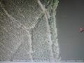
Potential launching site can be seen on aerial view
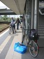
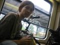
Bike and boat are waiting for adventure! ..aehh, train.
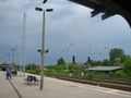
Darkening skies upon arrival at Gruenau
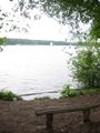
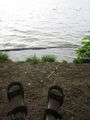
The idyllic place
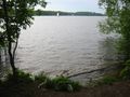
The idyllic place
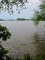
the idyllic place (before the rain)
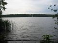
View in direction of the geohash
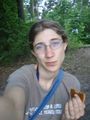
Eating a cookie at the idyllic place while the rain starts
Wildlife at the idyllic place
Wet bike and hasher have arrived at their place in the train


