2009-06-05 49 8
| Fri 5 Jun 2009 in Mannheim: 49.1501293, 8.5011525 geohashing.info google osm bing/os kml crox |
comment1, http://topchristianbiz.com/ zithromax, http://facingfortyforthrightly.com/ cheap lamictal, http://xdljs.net/ levitra, http://pastorcaleb.com/ levitra, http://screwprivacy.com/ cytotec medicine, http://saygoodbyetothepounds.com/ buy female viagra, http://aqracing.com/ reductil, http://honeypupcakery.com/ cialis mail order, http://outoftheboxtoys.com/ viagra, http://somethingsweetcakestudio.com/ acomplia buy rimonabant, http://santacruzac.com/ buy doxycycline,
comment6, http://thehuckabees.com/ retin-a, http://disekt.com/ ambien therapy brain injury, http://onlinephilippines.net/ online cialis fedex, http://webdesignbymorgan.com/ doxycycline doxicycline, http://vitamesh.com/ alcoholism antabuse medication, http://corrieredirozzano.com/ ativan withdrawl, http://coresportsllc.com/ alprazolam side affects, http://sweeteatsny.com/ viagra propecia online gt,
Expedition by Koepfel
Report
I left my home at about 17:40. I rode through Hagsfeld, Reitschulschlag and Blankenloch, mostly following the light rail tracks. After Blankenloch, I continued on non-paved paths through the fields, taking several detours, check the tracklog below. Eventually. I arrived in Spöck, from where it was another 4 kilometers to the Hash on a narrow, one-laned, but still heavily used road. Nearing the Hash (taken on the B36 bridge), I was getting more and more afraid that I'd have to trample crops if I actually wanted to reach the Hashpoint. Luckily, there were a few paths in the field without crops, that allowed me to near the Hashpoint up to 20 meters. Continuing to the Hashpoint might have been possible, however, this might have had resulted in some damaged crops, so I decided, that 20 meters is a reasonable distance to stop. After discussing this with other hashers on IRC and taking photos, I headed back to Spöck. There, I noticed my back tire sounding weird. I checked it and realized it did not have too much air left in it. Luckily, the light rail stop was not too far away and there was a train leaving in a few minutes. So before I get stranded in the middle of nowhere, I decided to take the train, which brought me back to Karlsruhe by 20:20.
Overall, not a too spectacular expedition, but it was good to go Geohashing again after two weeks without, Also, I won't make it to any other hashes this weekend, including one epic hash :(
Here's the Tracklog (.gpx, .kmz, in Google Maps) of my Home-to-Hash bike ride. Distance 18.7 km, duration: 1h 12min, avg. speed: 15,4 km/h.
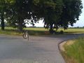
Which way should I go?
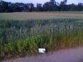
Hash Field
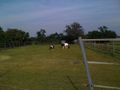
Geohorses in Spöck


