Difference between revisions of "2009-06-20 49 8"
From Geohashing
imported>Koepfel (New page: {{meetup graticule | lat=49 | lon=8 | date=2009-06-20 | graticule_name=Mannheim | graticule_link=Mannheim, Germany }} == Location == Today, the hashpoint is in a field near Neuenbürg, a ...) |
imported>Koepfel (+gallery) |
||
| Line 8: | Line 8: | ||
== Location == | == Location == | ||
| − | Today, the hashpoint is in a field near Neuenbürg, a formerly independent village, now a part of the town of [[ | + | Today, the hashpoint is in a field near Neuenbürg, a formerly independent village, now a part of the town of [[Wikipedia:Kraichtal|Kraichtal]], in which smaller villages were merged into in 1971. |
== Planning == | == Planning == | ||
| Line 15: | Line 15: | ||
=== Report === | === Report === | ||
''will be done'' | ''will be done'' | ||
| − | + | ||
<gallery> | <gallery> | ||
| − | Image:2009-06- | + | Image:2009-06-20 49 8-horses.jpg|Geohorses in Neuenbürg. |
| − | + | Image:2009-06-20 49 8-path.jpg|Many fields... | |
| − | Image:2009-06- | + | Image:2009-06-20 49 8-hash.jpg|...one of them containing the Hashpoint |
| − | + | Image:2009-06-20 49 8-marker.jpg|Reached. | |
| − | Image:2009-06- | + | Image:2009-06-20 49 8-train.jpg|S31 in Odenheim. |
| − | |||
| − | Image:2009-06- | ||
| − | Image:2009-06- | ||
| − | |||
| − | |||
</gallery> | </gallery> | ||
[http://geohash.koepfel.de/2009-06-20_49_8 (more pictures)] | [http://geohash.koepfel.de/2009-06-20_49_8 (more pictures)] | ||
| − | + | ||
[[Category:Expeditions]] | [[Category:Expeditions]] | ||
[[Category:Expeditions with photos]] | [[Category:Expeditions with photos]] | ||
[[Category:Coordinates reached]] | [[Category:Coordinates reached]] | ||
Revision as of 18:28, 21 June 2009
| Sat 20 Jun 2009 in Mannheim: 49.1625773, 8.7251129 geohashing.info google osm bing/os kml crox |
Location
Today, the hashpoint is in a field near Neuenbürg, a formerly independent village, now a part of the town of Kraichtal, in which smaller villages were merged into in 1971.
Planning
Taking the S32 light rail from Karlsruhe-Durlach to Menzingen, bike from there to the Hash, back via the S31 from Odenheim.
Expedition by Koepfel
Report
will be done
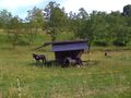
Geohorses in Neuenbürg.
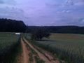
Many fields...
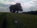
...one of them containing the Hashpoint
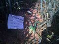
Reached.
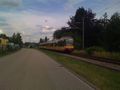
S31 in Odenheim.


