Difference between revisions of "2009-06-23 52 12"
imported>Pari (New page: {{subst:Expedition |lat = 52 |lon = 12 |date = 2009-06-23 }}) |
imported>FippeBot m (Location) |
||
| (2 intermediate revisions by one other user not shown) | |||
| Line 1: | Line 1: | ||
| − | |||
| − | |||
| − | |||
| − | |||
| − | |||
{{meetup graticule | {{meetup graticule | ||
| lat=52 | | lat=52 | ||
| Line 10: | Line 5: | ||
}} | }} | ||
| − | |||
__NOTOC__ | __NOTOC__ | ||
== Location == | == Location == | ||
| + | The hash point seems to be in the middle of a field. Some dirt tracks surround it from which access should be possible. | ||
== Participants == | == Participants == | ||
| + | [[User:pari|pari]] | ||
== Plans == | == Plans == | ||
| + | Very spontaneous mission. :) | ||
| + | |||
| + | getting to the town ''Werder (Havel)'' by train and walk the rest of the way. | ||
== Expedition == | == Expedition == | ||
| + | I started pretty late in the afternoon and arrived in Werder at around 19:15. I couldn't find a bus that would shorten the way I had to walk. So I went approx. 9 kilometers by foot. Almost there, a fence blocked my way saying there was a military area and trespassing was not allowed. A path around was found and soon an asphalt street crossed my way. I went along it until my GPS showed a direction exactly to the right. | ||
| − | + | A barley field was right in front of me and the hash point was 300 meters away, yet. The plants reached till my shoulders, I had trouble channeling my path and 100 meters later I finally gave up, also because my jeans were already ruined by grassy plots, the sun was just going down, and I had no flashlight with me. Nevertheless, I left a notice at the street that I was there - see photo. :) | |
| + | The way back was a bit easier. Half way, I stopped at a bus station and took a bus a few minutes later which took me to a train back to Berlin. At the station a met a young couple from the Netherlands who came the long way hitch-hiking. We had a wonderful conversation during the journey and I even told them about geohashing. They were pretty amazed by it and told me that they also have crazy hobbies. ;) Maybe we are going to welcome some Dutch visitors in our community. | ||
== Photos == | == Photos == | ||
| − | <gallery perrow=" | + | <gallery perrow="4"> |
| − | Image: | + | Image:2009_06_23_52_12_IMG_0201.JPG | beautiful way to the hash point |
| − | Image: | + | Image:2009_06_23_52_12_IMG_0206.JPG | military area, trespassers will be prosecuted |
| + | Image:2009_06_23_52_12_IMG_0208.JPG | bypassed the prohibited area, almost there | ||
| + | Image:2009_06_23_52_12_IMG_0210.JPG | hardly passable field | ||
| + | Image:2009_06_23_52_12_IMG_0211.JPG | sunset | ||
| + | Image:2009_06_23_52_12_IMG_0213.JPG | wicked reflections - does anybody know how to fix that? | ||
| + | Image:2009_06_23_52_12_IMG_0214.JPG | at least at the street :) with a scannable [http://en.wikipedia.org/wiki/QR_Code QR Code] | ||
</gallery> | </gallery> | ||
| − | |||
| − | |||
| − | |||
| − | |||
| − | |||
| − | |||
| − | |||
| − | |||
[[Category:Expeditions]] | [[Category:Expeditions]] | ||
[[Category:Expeditions with photos]] | [[Category:Expeditions with photos]] | ||
| − | |||
| − | |||
| − | |||
| − | |||
| − | |||
| − | |||
| − | |||
| − | |||
[[Category:Coordinates not reached]] | [[Category:Coordinates not reached]] | ||
| − | |||
[[Category:Not reached - Mother Nature]] | [[Category:Not reached - Mother Nature]] | ||
| − | + | {{location|DE|BB|PM}} | |
| − | |||
| − | |||
| − | |||
Latest revision as of 04:07, 8 August 2019
| Tue 23 Jun 2009 in 52,12: 52.3359257, 12.9058811 geohashing.info google osm bing/os kml crox |
Location
The hash point seems to be in the middle of a field. Some dirt tracks surround it from which access should be possible.
Participants
Plans
Very spontaneous mission. :)
getting to the town Werder (Havel) by train and walk the rest of the way.
Expedition
I started pretty late in the afternoon and arrived in Werder at around 19:15. I couldn't find a bus that would shorten the way I had to walk. So I went approx. 9 kilometers by foot. Almost there, a fence blocked my way saying there was a military area and trespassing was not allowed. A path around was found and soon an asphalt street crossed my way. I went along it until my GPS showed a direction exactly to the right.
A barley field was right in front of me and the hash point was 300 meters away, yet. The plants reached till my shoulders, I had trouble channeling my path and 100 meters later I finally gave up, also because my jeans were already ruined by grassy plots, the sun was just going down, and I had no flashlight with me. Nevertheless, I left a notice at the street that I was there - see photo. :)
The way back was a bit easier. Half way, I stopped at a bus station and took a bus a few minutes later which took me to a train back to Berlin. At the station a met a young couple from the Netherlands who came the long way hitch-hiking. We had a wonderful conversation during the journey and I even told them about geohashing. They were pretty amazed by it and told me that they also have crazy hobbies. ;) Maybe we are going to welcome some Dutch visitors in our community.
Photos
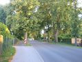
beautiful way to the hash point
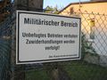
military area, trespassers will be prosecuted
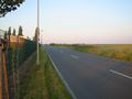
bypassed the prohibited area, almost there
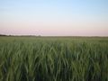
hardly passable field
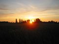
sunset
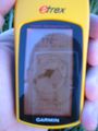
wicked reflections - does anybody know how to fix that?
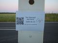
at least at the street :) with a scannable QR Code


