Difference between revisions of "2009-06-24 43 -79"
imported>Jiml m (Typos) |
imported>FippeBot m (Location) |
||
| (One intermediate revision by one other user not shown) | |||
| Line 39: | Line 39: | ||
[[Category:Expeditions]] | [[Category:Expeditions]] | ||
[[Category:Expeditions with photos]] | [[Category:Expeditions with photos]] | ||
| − | |||
[[Category:Coordinates not reached]] | [[Category:Coordinates not reached]] | ||
| − | [[Category:Not reached - | + | [[Category:Not reached - Attended alternate location]] |
| + | {{location|CA|ON}} | ||
Latest revision as of 04:08, 8 August 2019
| Wed 24 Jun 2009 in Toronto: 43.3286410, -79.5651450 geohashing.info google osm bing/os kml crox |
Contents
About
Today's geohash is in the middle of Lake Ontario.
One of the decihashes was on the corner of Glenorchy Rd. and Araz Pl. at 43.7286410, -79.3651450
Expedition
Splitdipless
Not being happy with the hash point. I decided to look up various decicules within the graticule and see if a decihash point would be close enough to get to. I found a point that fell within the neighbourhood of Bridle Path.
As this expedition was happening after work, I departed from work in my car 'Em' to get to the point. I parked on a side street and as soon as I directed my GPS to find the point, it alarmed to tell me that I was within a dozen meters. The point was on the corner of Glenorchy Rd. and Araz Pl. (although Google incorrectly calls it Glenorchy Pl.)
I took a few photos, took a snap of a house across the street, and began heading back. Just as I turned around in a millionaire's driveway, the millionaire was coming home. I made a hasty retreat rather then explain my stop in their community (I'm one of those crusty middle-class people). I ended up following a Porche out of there to the next major street.
I hereby dub decicule 43.7, -79.3 as 'Don Mills, Toronto' after the largest neighbourhood within the decicule.
Photos
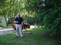
I found a cable box to capture a picture of me standing in front of Em.
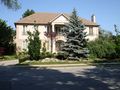
One of the 'cheap' places without a gate.
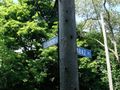
It's Araz Pl., not Glenorchy Pl.
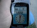
1/100th of a sucess!


