2009-06-26 54 8
| Fri 26 Jun 2009 in Tønder, Denmark: 54.9886395, 8.7552430 geohashing.info google osm bing/os kml crox |
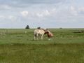
In a grazing meadow next to a farm at Gærup, about 3km northeast of Højer, Denmark. Reached at around 16:00 by dawidi from 49 12.
dawidi
Just like 2009-06-24 54 8, I started from Kiel on the NOB train to Husum at noon, but this time I had a good connection from Husum to the north. I got off at Klanxbüll, the last mainland station after which the train goes across the sea to Sylt, and was greeted by even stronger winds than two days ago. It was still an easterly wind, very unusual for the region, so I was lucky I hadn't planned a longer trip assuming a wind from the west.
Shaken about by said wind, I cycled north to the border, which was merely marked by an abandoned hut and some tourist information signs. From there, I followed a road going on for over 6 kilometers straight, without any intersections. I know that's nothing compared to roads in the US and Australia, but for a Central European, it's an amazing experience :)
In Højer, I turned right and crawled eastward against the wind, then turned north again and reached the hash hamlet.
(to be continued)


IT'S WINDYYY!
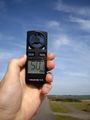
50kph wind!
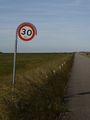
POSTED: Funny cane-shaped signs next 30 kilometers.
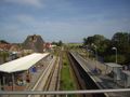
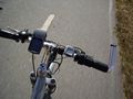
Back at the station in Klanxbüll


dawidi earned the Border geohash achievement
|