Difference between revisions of "2009-06-28 50 -1"
imported>Sermoa (Add an achievements section) |
imported>Sermoa m (Switch category to a successful geohash!) |
||
| Line 48: | Line 48: | ||
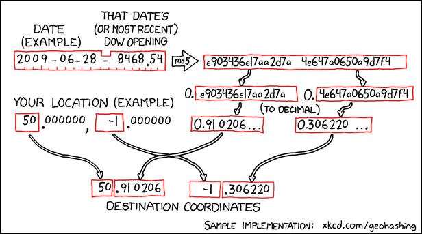
It's a combination of the date, the Dow Jones stock market data, an encryption algorithm, and a translation to geographic coordinates. We use 50, -1 to find the closest Geohash location to us, and look it up on a Google map to see where it falls. Quite often it's in the English Channel, or a field in the middle of nowhere. When it falls in a convenient place, such as Hedge End recreation ground, it's quite fun to go there to see if anyone else has come to the same place for the same reason! | It's a combination of the date, the Dow Jones stock market data, an encryption algorithm, and a translation to geographic coordinates. We use 50, -1 to find the closest Geohash location to us, and look it up on a Google map to see where it falls. Quite often it's in the English Channel, or a field in the middle of nowhere. When it falls in a convenient place, such as Hedge End recreation ground, it's quite fun to go there to see if anyone else has come to the same place for the same reason! | ||
| − | [[Category: | + | [[Category:Expeditions]] |
| + | [[Category:Coordinates reached]] | ||
Revision as of 20:08, 28 June 2009
| Sun 28 Jun 2009 in Southampton: 50.9102060, -1.3062207 geohashing.info google osm bing/os kml crox |
Contents
Location
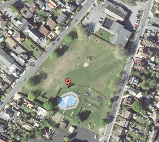
50.910206, -1.306221 - Right in the middle of Hedge End recreation ground! Plenty of space to play, pubs and cafes and shops nearby. A perfect geohash!
Participants
- Sermoa
- Macronencer
- Laura (a drag-along who didn't have a clue what was going on but turned up anyway!)
Details
1.9 mile walk from Hedge End train station
2.4 mile walk from Botley train station
Bluestar 3 bus goes from Southampton to Hedge End £5.30 return or from Bitterne £4.00 return.
Close to the M27.
Expedition
Sermoa's journey
I left home at 13:50, went to get the train from Winchester to Hedge End at 14:08, walked the 1.9 miles to the recreation ground, stopping to take photos, and going the wrong way only twice. I got to the recreation ground at about 15:40, poked my real-life google pin in the ground and then proceeded to feel rather embarrassed as everyone was there with children in the paddling pool, and i had no children! I was very relieved when Mike showed up!
We played music together, solved the Rubik's cube, juggled, took photos, and talked about our interests and our life experiences. It was so nice to get to know Mike, somebody i wouldn't have otherwise met, but we found we share some similar interests. We attracted a little attention from some nearby people, and we explained a little about xkcd and geohashing!
My friend Laura turned up at around 17:00, not even knowing why we were there or what geohashing was all about! I'd just said i'd be in Hedge End recreation ground and wasn't even expecting Laura to come! We all had a good time chatting and enjoying the weather together. In my opinion it was a most excellent geohashing adventure!
Achievements
How the location is calculated
It's a combination of the date, the Dow Jones stock market data, an encryption algorithm, and a translation to geographic coordinates. We use 50, -1 to find the closest Geohash location to us, and look it up on a Google map to see where it falls. Quite often it's in the English Channel, or a field in the middle of nowhere. When it falls in a convenient place, such as Hedge End recreation ground, it's quite fun to go there to see if anyone else has come to the same place for the same reason!

