Difference between revisions of "2009-06-30 53 -113"
From Geohashing
imported>Karl (→Expedition) |
m (More specific location) |
||
| (2 intermediate revisions by 2 users not shown) | |||
| Line 34: | Line 34: | ||
<gallery perrow="3"> | <gallery perrow="3"> | ||
| − | Image: | + | Image:2009_06_30_53_-113_karl_with_silly_grin.jpg| Witty Comment :) |
| − | |||
</gallery> | </gallery> | ||
| Line 43: | Line 42: | ||
--> | --> | ||
| − | |||
| − | |||
| − | |||
[[Category:Expeditions]] | [[Category:Expeditions]] | ||
[[Category:Expeditions with photos]] | [[Category:Expeditions with photos]] | ||
| − | |||
| − | |||
| − | |||
| − | |||
| − | |||
[[Category:Coordinates reached]] | [[Category:Coordinates reached]] | ||
| − | |||
<!-- or if you failed :( | <!-- or if you failed :( | ||
| Line 64: | Line 54: | ||
[[Category:Failed - Did not attempt]] | [[Category:Failed - Did not attempt]] | ||
--> | --> | ||
| + | {{location|CA|AB|ED}} | ||
Latest revision as of 23:05, 9 August 2020
| Tue 30 Jun 2009 in 53,-113: 53.4639121, -113.4266055 geohashing.info google osm bing/os kml crox |
Location
Just north east of the Grey Nuns Hospital. Looked accessible, and it was! :)
Participants
Just Karl (His first geohash, pretty much a spur-of-the-moment thing :)
Plans
Expedition
Surfing the web today, I read something about geohashing, and (this time) followed the link here. Looking up the hash for Edmonton's graticule, I discovered it was very close to my house, so I grabbed my trusty G1, installed [[1]], and off I went.
The area was easy to get to, and the co-ordinates landed me just off the sidewalk. I set up my tripod across the street, and snapped a pic.
Tracklog
Photos
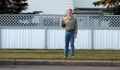
Witty Comment :)
