Difference between revisions of "2009-07-01 49 8"
imported>Fluxkompensator (→Planning: me midnight too :-)) |
imported>FippeBot m (Location) |
||
| (7 intermediate revisions by 2 users not shown) | |||
| Line 8: | Line 8: | ||
== Location == | == Location == | ||
| − | Today's hashpoint is in the [http://ka.stadtwiki.net/Schäferstraße Schäferstraße], near where it crosses the [http://ka.stadtwiki.net/Julius-Bender-Straße Julius-Bender-Straße], located in [[Wikipedia:Karlsruhe|Karlsruhe's]] suburb Hagsfeld. The exact location seems to be on a hedge seperating the road from a | + | Today's hashpoint is in the [http://ka.stadtwiki.net/Schäferstraße Schäferstraße], near where it crosses the [http://ka.stadtwiki.net/Julius-Bender-Straße Julius-Bender-Straße], located in [[Wikipedia:Karlsruhe|Karlsruhe's]] suburb Hagsfeld. The exact location seems to be on a hedge seperating the road from a private house, wheither it can be reached from the road remains to be seen. It's about 1.6 kilometers from [[User:Koepfel|Koepfel's]] home. |
== Planning == | == Planning == | ||
| − | I plan to bike there at 0:00 for the midnight achievement and walk there again on the following afternoon for daylight-photos and the walk geohash achievement. Maybe I'll also in the morning for the sunrise achievement (at 5:26). | + | I plan to bike there at 0:00 for the midnight achievement and walk there again on the following afternoon for daylight-photos and the walk geohash achievement, aiming at 16:00. <s>Maybe I'll also go in the morning for the sunrise achievement (at 5:26).</s> |
: I look forward meeting you, Koepfel, for a midnight geohash. --[[User:Fluxkompensator|Fluxkompensator]] 20:15, 30 June 2009 (UTC) | : I look forward meeting you, Koepfel, for a midnight geohash. --[[User:Fluxkompensator|Fluxkompensator]] 20:15, 30 June 2009 (UTC) | ||
| − | + | == Expedition by [[User:Koepfel|Koepfel]] == | |
| − | === Report === | + | === Report Part 1 === |
| + | I started the first expedition at about [http://geohash.koepfel.de/2009-07-01_49_8/pages/page_1.html 23:40], by bike. after a short ride, I arrived in the Schäferstraße 8 minutes before midinght and the GPS [http://geohash.koepfel.de/2009-07-01_49_8/pages/page_4.html zeroed] in right at the hedge. About five minutes later, Fluxkompensator arrived, also by bike. | ||
| + | |||
| + | At midnight, I took a screenshot of my GPS, while Fluxkompensator tried to take a photo of his, struggling with its nearly empty battery. After a while, we cycled back home, I arrived at my house at 0:30. | ||
| + | |||
| + | I didn't take any decent photos, but that's were we come to... | ||
| + | |||
| + | === Report Part 2 === | ||
| + | |||
| + | I left my home at about 15:30 again, this time [http://geohash.koepfel.de/2009-07-01_49_8/index2.html by foot]. I crossed the Hagsfeld bridge, over the [http://geohash.koepfel.de/2009-07-01_49_8/pages/page_13.html station] and turned into the [http://geohash.koepfel.de/2009-07-01_49_8/pages/page_17.html Julius-Bender-Straße]. Julius Bender was the Landesbischof of Baden (protestant Bishop of Baden) from 1946 - 1964, living in Karlsruhe, so this road was named for him. | ||
| + | |||
| + | [http://geohash.koepfel.de/2009-07-01_49_8/pages/page_24.html At 16:00], I was at the hashpoint again and left a [http://geohash.koepfel.de/2009-07-01_49_8/pages/page_25.html chalk marking] on the road. Near the Hashpoint I also discovered a [http://geohash.koepfel.de/2009-07-01_49_8/pages/page_31.html sports hall] and a [http://geohash.koepfel.de/2009-07-01_49_8/pages/page_33.html cemetery]. I also noticed, there was a [http://geohash.koepfel.de/2009-07-01_49_8/pages/page_30.html bus line] running next to the Hashpoint (line 32). For me, this has to be the most reachable hashpoint yet. | ||
| + | |||
| + | At about 16:11, I walked back home, arriving at 16:40. | ||
| + | |||
| + | Here's the Tracklog <span class="plainlinks">([http://geohash.koepfel.de/2009-07-01_49_8/2009-07-01_49_8.gpx .gpx], [http://geohash.koepfel.de/2009-07-01_49_8/2009-07-01_49_8.kmz .kmz], [http://maps.google.com/maps?q=http://geohash.koepfel.de/2009-07-01_49_8/2009-07-01_49_8.kmz in Google Maps])</span> of the very first bike ride there. I pretty much took the same way back and also walked the same way on the daylight-expedition. | ||
<gallery> | <gallery> | ||
| + | Image:2009-07-01 49 8-midnight.jpg|Geohashing in the dark. | ||
| + | Image:2009-07-01 49 8-clock.jpg|16 hours later (see below) | ||
| + | Image:2009-07-01 49 8-hash.jpg|reached | ||
| + | Image:2009-07-01 49 8-hash-road.jpg| | ||
| + | </gallery> | ||
| + | [http://geohash.koepfel.de/2009-07-01_49_8 (more pictures)] | ||
| + | |||
| + | {{Midnight geohash | latitude = 49 | longitude = 8 | date =2009-07-01 | name = Koepfel | image = 2009-07-01 49 8-midnight.jpg }} | ||
| + | {{Walk geohash | latitude = 49 | longitude = 8 | date = 2009-07-01 | name = Koepfel | distance = 4.3km }} | ||
| + | |||
| + | == Expedition by [[User:Fluxkompensator |Fluxkompensator ]] == | ||
| + | … co-ordinates reached … | ||
| + | |||
| + | <gallery> | ||
| + | Image:2009-07-01_49_8_hagsfeld-clock.jpg | ||
| + | Image:2009-07-01_49_8_gps.jpg | ||
| + | Image:20090701_49_8_meetup_bikes.jpg | ||
</gallery> | </gallery> | ||
| − | + | ||
| + | <br> | ||
[[Category:Expeditions]] | [[Category:Expeditions]] | ||
[[Category:Expeditions with photos]] | [[Category:Expeditions with photos]] | ||
| − | [[Category:Coordinates reached]] | + | [[Category:Coordinates reached]] |
| − | + | {{location|DE|BW|KA|city=true}} | |
Latest revision as of 04:17, 8 August 2019
| Wed 1 Jul 2009 in Mannheim: 49.0283638, 8.4602629 geohashing.info google osm bing/os kml crox |
Contents
Location
Today's hashpoint is in the Schäferstraße, near where it crosses the Julius-Bender-Straße, located in Karlsruhe's suburb Hagsfeld. The exact location seems to be on a hedge seperating the road from a private house, wheither it can be reached from the road remains to be seen. It's about 1.6 kilometers from Koepfel's home.
Planning
I plan to bike there at 0:00 for the midnight achievement and walk there again on the following afternoon for daylight-photos and the walk geohash achievement, aiming at 16:00. Maybe I'll also go in the morning for the sunrise achievement (at 5:26).
- I look forward meeting you, Koepfel, for a midnight geohash. --Fluxkompensator 20:15, 30 June 2009 (UTC)
Expedition by Koepfel
Report Part 1
I started the first expedition at about 23:40, by bike. after a short ride, I arrived in the Schäferstraße 8 minutes before midinght and the GPS zeroed in right at the hedge. About five minutes later, Fluxkompensator arrived, also by bike.
At midnight, I took a screenshot of my GPS, while Fluxkompensator tried to take a photo of his, struggling with its nearly empty battery. After a while, we cycled back home, I arrived at my house at 0:30.
I didn't take any decent photos, but that's were we come to...
Report Part 2
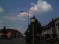
I left my home at about 15:30 again, this time by foot. I crossed the Hagsfeld bridge, over the station and turned into the Julius-Bender-Straße. Julius Bender was the Landesbischof of Baden (protestant Bishop of Baden) from 1946 - 1964, living in Karlsruhe, so this road was named for him.
At 16:00, I was at the hashpoint again and left a chalk marking on the road. Near the Hashpoint I also discovered a sports hall and a cemetery. I also noticed, there was a bus line running next to the Hashpoint (line 32). For me, this has to be the most reachable hashpoint yet.
At about 16:11, I walked back home, arriving at 16:40.
Here's the Tracklog (.gpx, .kmz, in Google Maps) of the very first bike ride there. I pretty much took the same way back and also walked the same way on the daylight-expedition.
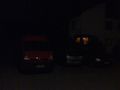
Geohashing in the dark.
16 hours later (see below)
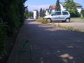
reached


Koepfel earned the Midnight Geohash achievement
|
Koepfel earned the Walk geohash Achievement
|
Expedition by Fluxkompensator
… co-ordinates reached …


