Difference between revisions of "2009-07-04 26 -80"
imported>Aperfectring (write up) |
m (Location correction) |
||
| (2 intermediate revisions by 2 users not shown) | |||
| Line 1: | Line 1: | ||
<!-- If you did not specify these parameters in the template, please substitute appropriate things for IMAGE, LAT, LON, and DATE (YYYY-MM-DD format) --> | <!-- If you did not specify these parameters in the template, please substitute appropriate things for IMAGE, LAT, LON, and DATE (YYYY-MM-DD format) --> | ||
| − | |||
| − | |||
| − | |||
{{meetup graticule | {{meetup graticule | ||
| lat=26 | | lat=26 | ||
| Line 27: | Line 24: | ||
== Photos == | == Photos == | ||
| − | <gallery perrow=" | + | <gallery perrow="4"> |
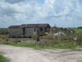
| − | Image:2009- | + | Image:2009-07-04_26_-80_apr_001.jpg|Two abandoned buildings in the middle of farm country. |
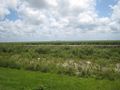
| − | Image:2009- | + | Image:2009-07-04_26_-80_apr_002.jpg|Believe it or not, that is a canal. |
| + | Image:2009-07-04_26_-80_apr_003.jpg|A sample of the No Trespassing signs that were all over the area. | ||
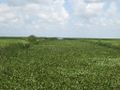
| + | Image:2009-07-04_26_-80_apr_004.jpg|Somewhere in all that sugar cane is the point =(. | ||
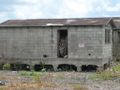
| + | Image:2009-07-04_26_-80_apr_005.jpg|Two more abandoned buildings. | ||
| + | Image:2009-07-04_26_-80_apr_006.jpg|Posted! As if I ''could'' get in there '''and''' I ''wanted'' to. | ||
| + | Image:2009-07-04_26_-80_apr_007.jpg|Driving this road is enough to drive someone crazy. | ||
</gallery> | </gallery> | ||
| Line 36: | Line 38: | ||
[[Category:Coordinates not reached]] | [[Category:Coordinates not reached]] | ||
[[Category:Not reached - No public access]] | [[Category:Not reached - No public access]] | ||
| + | {{location|US|FL|PL}} | ||
Latest revision as of 11:48, 25 October 2020
| Sat 4 Jul 2009 in 26,-80: 26.2025619, -80.8738082 geohashing.info google osm bing/os kml crox |
Location
On a sugar cane farm near Belle Glade.
Participants
Plans
None. I decided I was getting stir crazy, and the point looked like a good candidate to take me out for a drive for a couple hours.
Expedition
After gathering the typical stuff I headed out. Primarily it was just driving along highways. After I got onto some county roads, I saw a few abandoned buildings. I also saw tons of crumbling bridges over the canals. When I stopped to take pictures of the buildings, I saw a very discouraging No Trespassing sign. As I continued on my way to the farm plot which holds the point, I kept seeing more of those No Trespassing signs at every possible entry point to the farms. It was at this point I figured that I likely wouldn't be able to get very close to the point. However, I had driven for about an hour by now, so I continued to get as close as I could.
When I got to the parking location I had identified from the aerial photos, there were a few trucks parked there, and a couple trucks driving slowly down the road. I decided not to stop (the parking location looked to be private property, and I knew I wasn't getting close to the point). I then drove a bit down the road, and pulled off at one of the entrances to take a picture of a No Trespassing sign, and of the sugar cane. I decided to take a nearly Tron-worthy route, and go back a different way than I came. Again along the way I found some more abandoned buildings and stopped to take a picture. The rest of the drive was rather uneventful, other than driving on perhaps the straightest and flattest stretch of road I have ever seen.
Photos
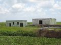
Two abandoned buildings in the middle of farm country.
Believe it or not, that is a canal.
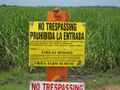
A sample of the No Trespassing signs that were all over the area.
Somewhere in all that sugar cane is the point =(.
Two more abandoned buildings.
Posted! As if I could get in there and I wanted to.
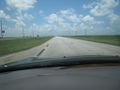
Driving this road is enough to drive someone crazy.


