Difference between revisions of "2009-07-05 49 -125"
imported>Xore m (→Photos) |
imported>Xore (→Courtenay) |
||
| Line 53: | Line 53: | ||
It took very little time before we were heading north (north-west, actually) on the highway. Courtenay is a small enough place that its name didn't start appearing on signs until we were fairly close. A few kilometres out, Xore and Elbie turned on their GPSs and started giving position reports. | It took very little time before we were heading north (north-west, actually) on the highway. Courtenay is a small enough place that its name didn't start appearing on signs until we were fairly close. A few kilometres out, Xore and Elbie turned on their GPSs and started giving position reports. | ||
| − | Unfortunately, the highway exit signage doesn't say the name of the road, only its destinations (Courtenay, Comox, and Cumberland) and that there were two exits for Courtenay; fortunately both Xore and Elbie reported that it ''had'' to be exit 117 because the hash point was within 2km and the exit was less than 1km away. | + | Unfortunately, the highway exit signage doesn't say the name of the road, only its destinations (Courtenay, Comox, and Cumberland) and that there were two exits for Courtenay; fortunately both Xore and Elbie reported that it ''had'' to be exit 117 because the hash point was within 2km and the exit was less than 1km away. ''Actually, the google maps said it was exit 117 --[[User:Xore|Xore]] 21:32, 7 July 2009 (UTC) '' |
As we drove down the road, we wondered what the big bare patch with a few terraces and access roads might be. | As we drove down the road, we wondered what the big bare patch with a few terraces and access roads might be. | ||
Revision as of 21:32, 7 July 2009
| Sun 5 Jul 2009 in 49,-125: 49.3518423, -125.1062209 geohashing.info google osm bing/os kml crox |
Contents
Location
Side of Inland Island Hwy, between Courtenay and Cumberland.
Participants
Planning
(More on the Talkpage)
Entirely subject to what the driver feels is most convenient for them. And Elbie will pay gas.
- 9:00 - pick up whoever is coming at seabus north terminal (8:45 departure from downtown)
- 10:40 - ferry to Departure Bay - plan to arrive at ticket booth ~9:30
- 12:20 - drive from Nanaimo to hashpoint
- 13:30 - arrive at hashpoint, celebrate leisurely
- 15:30 - drive back to Nanaimo
- 17:20 - ferry to Horseshoe Bay - plan to arrive at ticket booth ~16:30 [1] (note this is expected to be busy - there may be a sailing wait)
- ? - drive back to Vancouver, (maybe) get home for dinner
Expedition
Success! Report pending
Ferry

Rhonda, Xore, and Elbie met at the seabus north terminal at 9AM, where Elbie's bike was loaded onto the bike rack of Rhonda's car, everything else was thrown in a pile in the back, and all three set off to try and reach the Horseshoe Bay ferry ticket booths an hour before sailing. That should be enough time.
Only a year ago, this involved getting on Highway 1 westbound, and driving along it until it ended directly at the ferry toll booths. The ferry from Horseshoe Bay to Nanaimo is actually part of Highway 1, which continues on the island and goes from Nanaimo to Victoria. Now, due to highway construction for the upcoming winter olympics, staying on the highway means that you will end up heading for Whistler on highway 99.
Fortunately the ferry turnoff was well-signed, with a couple of notices starting a few kilometers back that ferry traffic should stay in the right lane. Past the exit, we were back on the old Highway 1 road, which goes steeply downhill, widens dramatically at the bottom, and ends in a dozen lanes, each with a toll booth at the bottom of the hill. (At the top of the hill is a place for trucks to stop and check their brakes, fortunately for the people in the toll booths...)
We got our ticket and into the lineup without incident, and went to check out the "Good Karma Cafe", which appeared to be the only food option in the parking area and was also a vegetarian-organic-hippie sort of place. Horseshoe Bay Village is in easy walking distance and has lots of restaurants, but is just out of earshot of the garbled announcements that tell you to get back into your cars. With less than an hour before boarding was likely to start, leaving the area is not a good idea.

Rhonda got excited when she saw a sign indicating that they sold cinnamon buns baked by Grounds for Coffee and shared one with Xore, while Elbie opted for the "Hippie Roll" because it had a funny name and avocado in it. It can't be bad if it has avocado in it.
On the ferry, we commandeered a table in the cafeteria despite not buying any food, and set up a game of The Downfall of Pompeii, in which Xore somehow got about five omen cards in a row and sacrificed almost all of Elbie and Rhonda's early population to the volcano, something they punished him for mightily when the lava started to flow.
The second game was more evenly matched, partly due to the players having more experience with the game and partly because people other than Xore actually got omen cards.
Courtenay
Although we had carefully looked up the turns we would need to take in order to get on the correct highway (19) going in the correct direction (north), we turned out to not need this information, as each turn we wanted was well signed and had dual turn bays. Almost as if the city planners had anticipated several hundred people, unfamiliar with the area, all wanting to take exactly the same initial route, all at the same time.
It took very little time before we were heading north (north-west, actually) on the highway. Courtenay is a small enough place that its name didn't start appearing on signs until we were fairly close. A few kilometres out, Xore and Elbie turned on their GPSs and started giving position reports.
Unfortunately, the highway exit signage doesn't say the name of the road, only its destinations (Courtenay, Comox, and Cumberland) and that there were two exits for Courtenay; fortunately both Xore and Elbie reported that it had to be exit 117 because the hash point was within 2km and the exit was less than 1km away. Actually, the google maps said it was exit 117 --Xore 21:32, 7 July 2009 (UTC)
As we drove down the road, we wondered what the big bare patch with a few terraces and access roads might be.
Then we saw a sign for a gravel pit, with a big gate across the driveway. Hmmm, not promising. However, the point was actually in the trees between the open space and the highway. If there was no access from this side, we could try from the side of the highway.
A little further down the road, we saw a sign for a Lafarge cement plant, with a big gate and a small building for site security to watch the gate from. This was also a little worrisome. But our plan had us going to the end of a dead end residential street which went a good ways toward the hash point and possibly well behind the active industrial area claimed by the two companies.
It was still a shorter overall direct route to park on the side of the highway, but from the residential street it was a shorter distance under the trees, so we continued.
The street names and turns appeared almost exactly as predicted, excepting a few short stubs of streets that were probably added recently, and we approached the end of the very narrow residential street. It was that variety of street where you dropped one wheel on the dirt shoulder to pass opposing traffic.
At the very end of the road was a long gravel driveway, which had a "private property" sign about two car lengths in from the road. And a spot wide and flat enough to fit two cars on the outside of the private property sign, without blocking the driveway.
At the hash point
Xore got a phone call as we were getting out of the car. It turns out that his sister, who he had invited to join us geohashing, had just missed the exit and was wondering where to meet us. He gave directions, and then we climbed up a hill (isn't it always?) which actually turned out to be a very short hill, and then stepped onto the big open area shown in google maps. That's exactly what it was. Flat, and dirt/gravel/rock mix, with no green growing things. There were no fences visible, and there were some donut-shaped skid marks in a few places along the way.
We walked all the way across and past some random industrial equipment that had been discarded, and into the forest. Xore decided to return to the car to fetch a couple of things we had forgotten (like the picnic blanket) and wait for his sister, since she didn't have a GPS. Elbie and Rhonda continued into the forest and attempted to locate the spot. Unfortunately, under the trees the GPS had very poor reception, and the best they could do was within 15m with a 21m accuracy. When Elbie stood still, the GPS "distance remaining" kept changing. So, they selected a decent picnic spot in the general vicinity of where the GPS thought the hashpoint might be. Then Elbie decided to go back for something she forgot in the car as well, and Rhonda opted to sit on a moss-covered fallen tree, swat at mosquitos, and wait for the others.
Xore's sister and her husband found us and parked, and all four walked back across the gravel field to the hashpoint. Xore promptly disappeared into the woods to try and get a lower number on the GPS while the rest started setting up the picnic at the spot Elbie's GPS had approved and started taunting Xore with announcements that he was missing out on the food. Everybody contributed something to the pile and we feasted on spanakopita, beef jerky, trail mix, fudge, carrots, buns, and babybel "cheese" in both red and yellow flavours.
Return to Nanaimo
Ferry lineup
Home
Elbie's spanakopita
Was super delicious and she promised to share the recipe with Rhonda! the recipe is now on Rhonda's talkpage!
Photos
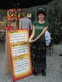
Elbie got a Hippie Roll
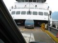
Boarding the Ferry
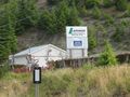
We thought the hashpoint might be in a LaFarge Compound
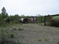
Gravel field we crossed on the way to the hashpoint
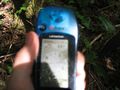
Coordinates Reached
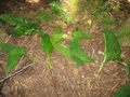
Leafy XKCD Sign on the hash point
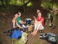
Picnic in the Forest
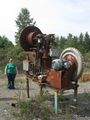
Xore's Sister and the Thing
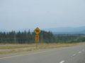
More signs, less Elk :(
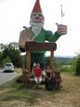
World Famous Gnome: And now you know


