Difference between revisions of "2009-07-13 45 -122"
imported>Jiml (First Draft) |
imported>FippeBot m (Location) |
||
| (9 intermediate revisions by 3 users not shown) | |||
| Line 13: | Line 13: | ||
== Participants == | == Participants == | ||
| − | * Tim F. | + | *[[User:Langly|Tim F.]] |
*[[User:Jiml|Jim]] | *[[User:Jiml|Jim]] | ||
| Line 35: | Line 35: | ||
== Expedition == | == Expedition == | ||
| + | ===Tim's trip === | ||
| + | Waited at the goodwill till 4:05 then went up to the hash, I lack GPS but did go, per my recollection off google maps it was just across from the lamp post evenly between two trees and right on someones red bush just off their shed just barely the other side of the wall. I tried to get back on here to see if Jim was still headed out and at one time but the wiki would not load. Failed meet due to wiki fail (is that an achivement? lol) | ||
| + | |||
===Jim's trip === | ===Jim's trip === | ||
| − | + | After work, I set off to the hashpoint. I hadn't heard at all from Tim, so I didn't think I would meet anyone | |
| − | + | there. I knew where I was headed to, pretty much, so I didn't print out anything. When I got to the street, I looked for a good place to park, and decided to park at the High School, it being closed for the Summer. | |
| + | (Hillsboro, Oregon has no less than 4 high schools. One just opened up in the last 7 years or so, which | ||
| + | I guess is forever in "school system years". | ||
| − | I | + | I started to walk to the hashpoint, fearing that it would end up over the nearby brick wall. As I got closer and closer, |
| − | of geocaching points on the way. The first one, at a Taco Bell, I think, was a | + | I was somewhat surprised to find the GPS pointing towards the street, not the back yard. I wandered into the |
| − | + | side median, and the GPS told me I was there! It might be that the accuracy of ~14 feet is an issue. | |
| + | |||
| + | I took some pictures of me and the GPS, and put a marking into the bark dust for others to see. | ||
| + | |||
| + | I then headed home, figuring I'd try a couple | ||
| + | of geocaching points on the way. The first one, at a Taco Bell, I think, was a unsuccessful. | ||
| + | The second one | ||
was at a nearby wildlife preserve, Jackson Bottom, which is a part of the Tualatin River watershed. | was at a nearby wildlife preserve, Jackson Bottom, which is a part of the Tualatin River watershed. | ||
| − | |||
The area is a stopover for lots of migratory waterfowl on their way from the south, where no-one seems | The area is a stopover for lots of migratory waterfowl on their way from the south, where no-one seems | ||
to geohash, to the north, where a bunch of folks do completely insane things, but people worldwide read | to geohash, to the north, where a bunch of folks do completely insane things, but people worldwide read | ||
their stories! | their stories! | ||
| + | I had no luck at that cache site either. Maybe I need | ||
| + | to try geocaching with someone who has luck with it. I did take some pictures of Jackson Bottom, one of the | ||
| + | area, and one of a Native Plants display. | ||
| − | |||
| − | |||
| − | + | == Photos == | |
| − | |||
| − | |||
| − | == | ||
| + | <gallery perrow="3"> | ||
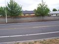
| − | + | Image:2009-07-13_45_-122-hs1.jpg |The (very) nearby high school | |
| + | Image:2009-07-13_45_-122-hashpt.jpg | Picture of the hashpoint | ||
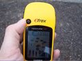
| + | Image:2009-07-13_45_-122-grin.jpg | Me and my GPS | ||
| + | Image:2009-07-13_45_-122-proof.jpg |Hashpoint proof | ||
| + | Image:2009-07-13_45_-122-xkcd.jpg | Result of our "marked earth" policy | ||
| − | + | Image:2009-07-13_45_-122-cache1.jpg | The alleged geocache point | |
| − | Image:2009- | + | Image:2009-07-13_45_-122-jack1.jpg | Jackson Bottom Wildlife refuge |
| − | Image:2009- | + | Image:2009-07-13_45_-122-jack2.jpg | Jackson Bottom Native plants |
</gallery> | </gallery> | ||
| − | |||
[[Category:Expeditions]] | [[Category:Expeditions]] | ||
[[Category:Expeditions with photos]] | [[Category:Expeditions with photos]] | ||
[[Category:Coordinates reached]] | [[Category:Coordinates reached]] | ||
| + | {{location|US|OR|WI}} | ||
Latest revision as of 04:30, 8 August 2019
| Mon 13 Jul 2009 in 45,-122: 45.5060928, -122.9168113 geohashing.info google osm bing/os kml crox |
Location
Just across from Century High school - Southern part of Hillsboro, near TV Highway
Participants
Plans
- I will be down at the goodwill outlet around 4~ about 900m away, if others are coming Ill head up and use the high school parking lot just across from the point, hence I suggested meeting up at the outlet first on the map. Tim F.
- Sounds like you are pretty certain to go. Shall we start an expedition page? 2009-07-13_45_-122 - Jim
- I'm interested in coming by, but I'll probably not be able to sneak out of work before 5. Jiml 18:25, 13 July 2009 (UTC)
Drove by it earlier on my way to get lunch, looks like its just 2 feet behind a stone wall in someones back yard, but the sidewalk is just the other side. Tim F.
I'll be outside the goodwill at 4 to see if anyone else is going to want to go up to the point, otherwise I will just drive past later. Tim F.
Expedition
Tim's trip
Waited at the goodwill till 4:05 then went up to the hash, I lack GPS but did go, per my recollection off google maps it was just across from the lamp post evenly between two trees and right on someones red bush just off their shed just barely the other side of the wall. I tried to get back on here to see if Jim was still headed out and at one time but the wiki would not load. Failed meet due to wiki fail (is that an achivement? lol)
Jim's trip
After work, I set off to the hashpoint. I hadn't heard at all from Tim, so I didn't think I would meet anyone there. I knew where I was headed to, pretty much, so I didn't print out anything. When I got to the street, I looked for a good place to park, and decided to park at the High School, it being closed for the Summer. (Hillsboro, Oregon has no less than 4 high schools. One just opened up in the last 7 years or so, which I guess is forever in "school system years".
I started to walk to the hashpoint, fearing that it would end up over the nearby brick wall. As I got closer and closer, I was somewhat surprised to find the GPS pointing towards the street, not the back yard. I wandered into the side median, and the GPS told me I was there! It might be that the accuracy of ~14 feet is an issue.
I took some pictures of me and the GPS, and put a marking into the bark dust for others to see.
I then headed home, figuring I'd try a couple of geocaching points on the way. The first one, at a Taco Bell, I think, was a unsuccessful. The second one was at a nearby wildlife preserve, Jackson Bottom, which is a part of the Tualatin River watershed. The area is a stopover for lots of migratory waterfowl on their way from the south, where no-one seems to geohash, to the north, where a bunch of folks do completely insane things, but people worldwide read their stories! I had no luck at that cache site either. Maybe I need to try geocaching with someone who has luck with it. I did take some pictures of Jackson Bottom, one of the area, and one of a Native Plants display.
Photos

The (very) nearby high school
Picture of the hashpoint

Me and my GPS
Hashpoint proof
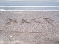
Result of our "marked earth" policy
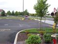
The alleged geocache point
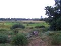
Jackson Bottom Wildlife refuge
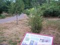
Jackson Bottom Native plants


