2009-07-14 49 -122
From Geohashing
Revision as of 19:26, 15 July 2009 by imported>Robyn (Sectionizing -- I'll work on assembly up to reaching the park.)
| Tue 14 Jul 2009 in 49,-122: 49.3504257, -122.8322685 geohashing.info google osm bing/os kml crox |
Contents
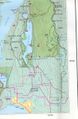
Location
In the Siskin Lake/Robin Lake area, east of Buntzen Lake on top of a mountain. There are established hiking trails there. See hiking trails map in photos section.
Participants
Plans
Meet after work and drive to Buntzen Lake picnic area. Hike ~4km on a trail (note: switchbacks - may be longer, will be steep), find hash point, hike down.
Sunset is at 9:13PM. We're bringing headlamps and jackets (and emergency gear) in case we're returning in the dark. Weather forecast calls for clearing skies through the day.
Expedition
Park gates closed at 9PM and we didn't want to have the car locked in the park overnight. We reached our designated turnaround time before we reached the hashpoint.
Full report tomorrow.
Assembling the Party
The First Foray
The Trail Up
The Junction
The Other Trail
The Race for the Car
Tracklog
Photos
map
