Difference between revisions of "2009-08-01 49 -113"
imported>Elbie (→Photos: half up) |
imported>Elbie (→Photos) |
||
| Line 32: | Line 32: | ||
==Photos== | ==Photos== | ||
| − | |||
| − | |||
<gallery> | <gallery> | ||
Image:2009-08-01 49 -113 toMonarch.jpg | Driving to Monarch | Image:2009-08-01 49 -113 toMonarch.jpg | Driving to Monarch | ||
Image:2009-08-01 49 -113 rangeRd241.jpg | Range Rd 24-1 | Image:2009-08-01 49 -113 rangeRd241.jpg | Range Rd 24-1 | ||
Image:2009-08-01 49 -113 canola.jpg | The canola directly west of the field where the hash was | Image:2009-08-01 49 -113 canola.jpg | The canola directly west of the field where the hash was | ||
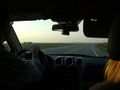
| − | Image:2009-08-01 49 -113 gpsCar.jpg | Aaaaand now we | + | Image:2009-08-01 49 -113 gpsCar.jpg | Aaaaand now we get out of the car... |
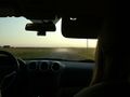
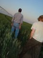
| + | Image:2009-08-01 49 -113 enteringField.jpg | Out of the car, heading into the field | ||
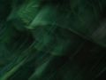
| + | Image:2009-08-01 49 -113 wheatBlurr.jpg | Pictures shortly thereafter mostly looked like this. | ||
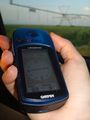
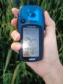
| + | Image:2009-08-01 49 -113 gps.jpg | Least blurry GPS-shot at the point! | ||
| + | Image:2009-08-01 49 -113 atHash.jpg | Elbie tries to swat off the half-dozen mosquitos attacking her back. | ||
Image:2009-08-01 49 -113 bugs.jpg | Mosquito carnage. | Image:2009-08-01 49 -113 bugs.jpg | Mosquito carnage. | ||
| + | Image:2009-08-01 49 -113 sandals.jpg | And for reference, what Elbie sprinted 400 metres in. | ||
</gallery> | </gallery> | ||
Revision as of 04:13, 2 August 2009
| Sat 1 Aug 2009 in 49,-113: 49.8330528, -113.1372207 geohashing.info google osm bing/os kml crox |
Location
On the pivot line of a wheat farm outside Monarch, Alberta.
Participants
- Elbie
- Elbie's Dad
- Elbie's Mom
- Elbie's friend Cameron
Expedition
The four of adventurers piled into Elbie's parents' Saturn hybrid around 20:45 for a quick drive over to Monarch, a little crap-town outside their home Lethbridge, a somewhat larger little crap-town.
Fields of wheat were seen. And some canola. Often there were cows, both seen and smelt.
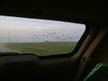
Twenty minutes later, they found themselves on Range Road 24-1. Stopping to open a window from the Faraday Cage that is the car, a GPS lock was acquired. They'd gone too far south -- and so turned around, eventually getting to the right latitude, getting as close to the hashpoint as they could from the road. This was exactly 196 metres west of the hash, according to the GPS.
Mosquitos were swarming the car. And not just the little excuses for mosquitos that Elbie was used to seeing in British Columbia, but rather, the giant monsters that fill the skies of the prairies.
Elbie's Mom advised calling it "good enough." However, Elbie, wearing a full-length summer skirt, a spaghetti strap tank top, and impractical but cute sandals, wasn't up for calling it quits yet: "I could run it."
And so, undaunted, Elbie, her Dad, and her friend quickly scrambled out of the car, only to be immediately swarmed by the mosquitos. The three brave stupid adventures then went fleeing into the waist-high wheat, running as fast as they could. Elbie called out the distances as they ran -- "60 metres left -- 35 -- 15 -- 18 -- okay, turn around!"
Stopping for about a minute to take blurry photos while jumping about and trying to shake as many of the unforgiving mosquitos off her body as she could, Elbie eventually got one of her GPS. She passed the camera onto her father, and now having mosquitos getting into her skirt, made a run for it.
The three sprinted the 200 metres back to the car, and without stopping, back into the car. After closing the doors, a fury of mosquito killing occurred, and then the four were on their way back home.
Photos
Driving to Monarch
Range Rd 24-1
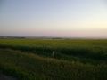
The canola directly west of the field where the hash was
Aaaaand now we get out of the car...
Out of the car, heading into the field
Pictures shortly thereafter mostly looked like this.
Least blurry GPS-shot at the point!
- Error creating thumbnail: Unable to save thumbnail to destination
Elbie tries to swat off the half-dozen mosquitos attacking her back.
Mosquito carnage.
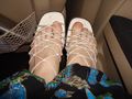
And for reference, what Elbie sprinted 400 metres in.


Ribbons
- Virgin graticule for all
- Land for all
- Running in sandals and skirt through waist-high wheat while being eaten alive by mosqutios gratuitous ribbon for Elbie