Difference between revisions of "2009-08-10 50 -1"
imported>Macronencer (Macronencer planning to do this hash) |
imported>FippeBot m (Location) |
||
| (5 intermediate revisions by one other user not shown) | |||
| Line 15: | Line 15: | ||
== Participants == | == Participants == | ||
| − | [[User:Macronencer|Macronencer]] | + | [[User:Macronencer|Macronencer]] |
== Plans == | == Plans == | ||
| Line 23: | Line 23: | ||
== Expedition == | == Expedition == | ||
| + | === [[User:Macronencer|Macronencer]] === | ||
| − | + | I didn't have enough time to do this one entirely by bike and get back before dark - and I would have been very tired anyway. So I drove into Southampton and parked in Eastgate Street. NOTE: This cost me 4.80 GBP. It would have been 3 pounds but I arrived before 18:00. This was actually more expensive than the ferry (return price 4.60 GBP) :( | |
| + | It was a short 1km ride to the ferry terminal, where I only had to wait about ten minutes. The crossing is quite brief too, but was bracing, with a stiff breeze! When we reached Hythe I cycled to the hash using my eTrex on its new rail mount, which arrived today, just in time for this trip! I like having to do some of the work, rather than have the route mapped out for me. In the old days before I got a TomTom, I used to use an old Garmin GPS12 in my car, and just look at where the arrow was pointing and find a way through the streets - it's fun! So I did the same thing, using my vague memory of the layout of Hythe (I've been there a few times) and watching the direction pointer on the eTrex. | ||
| + | |||
| + | Soon I was in the New Forest. It's so easy to go across on the ferry, I can't believe I haven't done this before! You can take a bike across at weekends if the weather is nice, and you'd be able to see a lot of lovely scenery before returning. Anyway, it was about 7 km to the hash by road, although I stopped once or twice to check Google Maps on the iPhone and make sure I had not gone a difficult way (when I get fitter this won't matter so much). The target was in some heathland near woods, and I stopped when the turn indicator said LEFT 90, to minimize the distance I'd have to go across the heath. I thought I could walk with the bike: however, it was much tougher than I expected, with frequent boggy potholes, and like a fool, I had worn shorts instead of leggings. I began to wonder whether there were ticks, and decided probably not (the grass wasn't long) but still it was uncomfortable, so I headed back to the road and cycled to the woodland. It turned out there was a flatter area alongside the woods, so I went that way. | ||
| + | |||
| + | Eventually I was 45m from the hash and it was directly to my right, so I abandoned the bike and proceeded on foot. It was quite tricky to get the right position because the difficult ground made it hard to do the "GPS dance" - but I got 1m away in the end so I was happy. | ||
| + | |||
| + | I had heard that [[User:04housemat|04housemat]], [[User:mahahahaneapneap|mahahahaneapneap]] and maybe [[User:donks169|donks169]] would be there at 14:00, but I could not see a marker anywhere. It was pretty hard to look for markers though, and I may have missed it. | ||
| + | |||
| + | Job done, I cycled back to Hythe and saw the ferry was in! So I went down the ramp (now much steeper as the tide had gone out) but was told that they had to re-fuel and I must wait half an hour. So I went to explore the town, but the only places open were a pub and a pizza parlour. | ||
| + | |||
| + | Finally got on the ferry at 2015 and we headed home. I got talking to a nice chap called Phillip, the first mate on board. It was very rewarding to speak to him because although he had not heard of geohashing, his nautical training made it easy for him to grasp it, which was a refreshing change from the usual blank stares. He was good at mental arithmetic too: he knew how wide a graticule was at our latitude, and when I mentioned that it was hard to find the marker because the GPS was accurate to about 5m, he immediately commented "yes, that would be about 75 square metres of area to search". | ||
| + | |||
| + | It was a good trip! I was so pleased that I had managed to use the ferry and had cycled in the New Forest, all on a Monday evening after work, that I barely noticed the damp weather. There was very little rain, which I had predicted, having consulted the excellent Weather Pro iPhone app and looked at the radar and satellite animations for the area. That app is worth every penny! What rain there was, was little more than fine mist. | ||
| + | |||
| + | Here's to many more like that! | ||
| + | |||
| + | P.S. The Hythe ferry web site has a webcam: [http://www.hytheferry.co.uk/ here] - just think, if you'd been watching at the right time, you might have seen me walking down the pier. Hmmm, I wonder whether there should be an achievement for visiting a hash in sight of a webcam and proving it with a screen capture of you on the webcam? I think that would be very interesting! Unlikely to happen, though (but not nearly as unlikely as a couch potato). | ||
== Photos == | == Photos == | ||
| − | + | <gallery perrow="4"> | |
| − | <gallery perrow=" | + | Image:2009-08-10_50_-1_Macronencer_01.jpg | All aboard! |
| − | Image:2009- | + | Image:2009-08-10_50_-1_Macronencer_02.jpg | See you later, Southampton |
| − | Image:2009- | + | Image:2009-08-10_50_-1_Macronencer_03.jpg | Hythe Ferry pier |
| + | Image:2009-08-10_50_-1_Macronencer_04.jpg | Ferry web site says this is the world's oldest pier train, a Guinness record | ||
| + | Image:2009-08-10_50_-1_Macronencer_05.jpg | Ferry departing. The Itchen Bridge is in the background | ||
| + | Image:2009-08-10_50_-1_Macronencer_06.jpg | The New Forest. Much better than the old one, which had too many trees... | ||
| + | Image:2009-08-10_50_-1_Macronencer_07.jpg | Cattle | ||
| + | Image:2009-08-10_50_-1_Macronencer_08.jpg | Ponies - and a foal, for the gushy amongst you | ||
| + | Image:2009-08-10_50_-1_Macronencer_09.jpg | Hash in view! | ||
| + | Image:2009-08-10_50_-1_Macronencer_10.jpg | Mostly dry, but occasional ponds to catch me out | ||
| + | Image:2009-08-10_50_-1_Macronencer_11.jpg | 45m away, had to abandon the bike. That landscape is harder to cross than it looks. | ||
| + | Image:2009-08-10_50_-1_Macronencer_12.jpg | Yay! Co-ordinates reached. | ||
| + | Image:2009-08-10_50_-1_Macronencer_13.jpg | No sign of a marker from the others, but there were a few of these flattened tussocks. | ||
| + | Image:2009-08-10_50_-1_Macronencer_14.jpg | Stupid grin! | ||
| + | Image:2009-08-10_50_-1_Macronencer_15.jpg | This is my "before" photo. Take note! After cycling 100 hashes I will post the "after" one :) | ||
| + | Image:2009-08-10_50_-1_Macronencer_16.jpg | Phillip, first mate of the Hythe Ferry, and an honorary geek! | ||
</gallery> | </gallery> | ||
| − | |||
| − | |||
| − | |||
| − | |||
| − | |||
| − | |||
| − | |||
[[Category:Expeditions]] | [[Category:Expeditions]] | ||
[[Category:Expeditions with photos]] | [[Category:Expeditions with photos]] | ||
| + | <!-- | ||
[[Category:Expeditions with videos]] | [[Category:Expeditions with videos]] | ||
| − | |||
--> | --> | ||
| − | |||
[[Category:Coordinates reached]] | [[Category:Coordinates reached]] | ||
| − | + | {{location|GB|ENG|HAM}} | |
| − | |||
| − | |||
| − | |||
| − | |||
| − | |||
| − | |||
| − | |||
| − | |||
| − | |||
Latest revision as of 05:08, 8 August 2019
| Mon 10 Aug 2009 in 50,-1: 50.8559601, -1.4619887 geohashing.info google osm bing/os kml crox |
Location
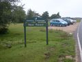
In the New Forest, not far from Hythe.
Participants
Plans
Macronencer plans to try to get to this one, probably by driving into Southampton, catching the Hythe Ferry and then cycling the rest of the way. It all depends whether his car is available (having work done on the brakes).
Expedition
Macronencer
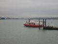
I didn't have enough time to do this one entirely by bike and get back before dark - and I would have been very tired anyway. So I drove into Southampton and parked in Eastgate Street. NOTE: This cost me 4.80 GBP. It would have been 3 pounds but I arrived before 18:00. This was actually more expensive than the ferry (return price 4.60 GBP) :(
It was a short 1km ride to the ferry terminal, where I only had to wait about ten minutes. The crossing is quite brief too, but was bracing, with a stiff breeze! When we reached Hythe I cycled to the hash using my eTrex on its new rail mount, which arrived today, just in time for this trip! I like having to do some of the work, rather than have the route mapped out for me. In the old days before I got a TomTom, I used to use an old Garmin GPS12 in my car, and just look at where the arrow was pointing and find a way through the streets - it's fun! So I did the same thing, using my vague memory of the layout of Hythe (I've been there a few times) and watching the direction pointer on the eTrex.
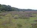
Soon I was in the New Forest. It's so easy to go across on the ferry, I can't believe I haven't done this before! You can take a bike across at weekends if the weather is nice, and you'd be able to see a lot of lovely scenery before returning. Anyway, it was about 7 km to the hash by road, although I stopped once or twice to check Google Maps on the iPhone and make sure I had not gone a difficult way (when I get fitter this won't matter so much). The target was in some heathland near woods, and I stopped when the turn indicator said LEFT 90, to minimize the distance I'd have to go across the heath. I thought I could walk with the bike: however, it was much tougher than I expected, with frequent boggy potholes, and like a fool, I had worn shorts instead of leggings. I began to wonder whether there were ticks, and decided probably not (the grass wasn't long) but still it was uncomfortable, so I headed back to the road and cycled to the woodland. It turned out there was a flatter area alongside the woods, so I went that way.
Eventually I was 45m from the hash and it was directly to my right, so I abandoned the bike and proceeded on foot. It was quite tricky to get the right position because the difficult ground made it hard to do the "GPS dance" - but I got 1m away in the end so I was happy.
I had heard that 04housemat, mahahahaneapneap and maybe donks169 would be there at 14:00, but I could not see a marker anywhere. It was pretty hard to look for markers though, and I may have missed it.
Job done, I cycled back to Hythe and saw the ferry was in! So I went down the ramp (now much steeper as the tide had gone out) but was told that they had to re-fuel and I must wait half an hour. So I went to explore the town, but the only places open were a pub and a pizza parlour.
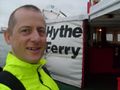
Finally got on the ferry at 2015 and we headed home. I got talking to a nice chap called Phillip, the first mate on board. It was very rewarding to speak to him because although he had not heard of geohashing, his nautical training made it easy for him to grasp it, which was a refreshing change from the usual blank stares. He was good at mental arithmetic too: he knew how wide a graticule was at our latitude, and when I mentioned that it was hard to find the marker because the GPS was accurate to about 5m, he immediately commented "yes, that would be about 75 square metres of area to search".
It was a good trip! I was so pleased that I had managed to use the ferry and had cycled in the New Forest, all on a Monday evening after work, that I barely noticed the damp weather. There was very little rain, which I had predicted, having consulted the excellent Weather Pro iPhone app and looked at the radar and satellite animations for the area. That app is worth every penny! What rain there was, was little more than fine mist.
Here's to many more like that!
P.S. The Hythe ferry web site has a webcam: here - just think, if you'd been watching at the right time, you might have seen me walking down the pier. Hmmm, I wonder whether there should be an achievement for visiting a hash in sight of a webcam and proving it with a screen capture of you on the webcam? I think that would be very interesting! Unlikely to happen, though (but not nearly as unlikely as a couch potato).
Photos
All aboard!
See you later, Southampton
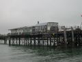
Hythe Ferry pier
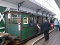
Ferry web site says this is the world's oldest pier train, a Guinness record
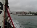
Ferry departing. The Itchen Bridge is in the background
The New Forest. Much better than the old one, which had too many trees...
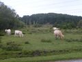
Cattle
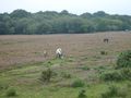
Ponies - and a foal, for the gushy amongst you
Hash in view!
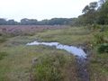
Mostly dry, but occasional ponds to catch me out
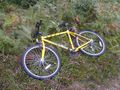
45m away, had to abandon the bike. That landscape is harder to cross than it looks.
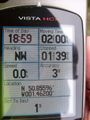
Yay! Co-ordinates reached.
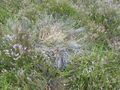
No sign of a marker from the others, but there were a few of these flattened tussocks.
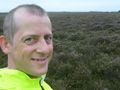
Stupid grin!
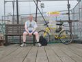
This is my "before" photo. Take note! After cycling 100 hashes I will post the "after" one :)

Phillip, first mate of the Hythe Ferry, and an honorary geek!


