Difference between revisions of "2009-08-12 48 12"
imported>Dawidi m (minor meeting point change) |
imported>Dawidi (writeup and photos of the main expedition) |
||
| Line 8: | Line 8: | ||
}} | }} | ||
| − | In a shrubbery near Burgweinting, southeast of Regensburg | + | In a shrubbery in the corner of a corn field near Burgweinting, southeast of Regensburg. |
| − | [ | + | [[User:dawidi|dawidi]] emailed a number of people for a meetup around 18:30, and eventually eight people made it there. |
| − | [ | + | == Scouting expedition == |
| + | [http://maps.landkreis-regensburg.de/default.aspx?MapStyle=h&CenterLatitude=48.995005&CenterLongitude=12.136975&DefaultZoom=18&DefaultThema=1&IgnorePinIDs=1;2;3;4;5; Aerial images] (switch to bird's eye view) are looking good, the bushes should be accessible via the field tracks from the east... | ||
| − | |||
Ich hab mir das Gelände vormittags schon mal angeschaut... der direkte Weg von der Hauptstraße aus wird von einem Zeugen-Jehovas-Grundstück versperrt, und der nächst naheliegende Weg hat sich als private Kleingartensiedlung herausgestellt. | Ich hab mir das Gelände vormittags schon mal angeschaut... der direkte Weg von der Hauptstraße aus wird von einem Zeugen-Jehovas-Grundstück versperrt, und der nächst naheliegende Weg hat sich als private Kleingartensiedlung herausgestellt. | ||
| Line 21: | Line 21: | ||
Wir treffen uns gegen 18:30 auf dem Weg entlang der Autobahn-Lärmschutzwand, in der Nähe vom Hash. -- [[User:Dawidi|dawidi]] 10:39, 12 August 2009 (UTC) | Wir treffen uns gegen 18:30 auf dem Weg entlang der Autobahn-Lärmschutzwand, in der Nähe vom Hash. -- [[User:Dawidi|dawidi]] 10:39, 12 August 2009 (UTC) | ||
| − | [[Category: | + | == Evening expedition == |
| + | Heading towards the meetup, dawidi realized the most direct way to the hash from the main road wasn't blocked at all, it just went very closely past the Jehovah's Witnesses' property. So he met up with Jochen and Nicole on the field track and they parked their bikes next to the corn field in which the hash ought to be. Just as they were about to go into the field, Hans and Tomcat showed up unexpectedly, and joined them. | ||
| + | |||
| + | The way through the field towards the hash was easy, and they determined the exact spot to be next to the shrubbery, in the somewhat muddy, but open corner of the corn field. Through the field, dawidi saw two cyclists arrive, and a couple of minutes later, they called him on his cellphone asking how to get to the hash - apparently they didn't have their GPSes with them, or had forgotten to enter the hash as a waypoint. Shortly after they emerged from between the tall corn plants: huirad and flomigulau, familiar faces from the [http://www.geocaching.com/seek/cache_details.aspx?guid=fcdf06cd-536c-467d-b1c9-3a5ddcdf3b95 Regensburg geocaching regulars' table]. | ||
| + | |||
| + | After posing for a group photo, Jochen and Nicole had to leave to secure a table in a rather crowded beer garden in town where dawidi (and other friends who couldn't make it to the hash) would join them later. | ||
| + | |||
| + | Then Der_Elch, another geocacher, showed up, we took some more pictures, marveled at the sillyness of this enterprise, and left the field. Without much further ado, we returned to the main road and split up shortly before 19:00. | ||
| + | |||
| + | <gallery> | ||
| + | Image:2009-08-12 48 12 dawidi gps.jpg|Coordinates reached | ||
| + | Image:2009-08-12 48 12 dawidi group.jpg|dawidi, Tomcat, Hans, Jochen, huirad, flomigulau, Nicole | ||
| + | Image:2009-08-12 48 12 dawidi group elch.jpg|Hans, huirad, Tomcat, flomigulau, Der_Elch, dawidi | ||
| + | Image:2009-08-12 48 12 corn field corner.jpg|The hash is into that field, along the shrubbery to the right | ||
| + | </gallery> | ||
| + | [[Image:2009-08-12 48 12 hashpano.jpg|thumb|640px|none|Panorama near the hashpoint.]] | ||
| + | |||
| + | {{drag-along | latitude = 48 | longitude = 12 | date = 2009-08-12 | ||
| + | | partner = Jochen, Nicole, huirad, flomigulau and Der_Elch | ||
| + | | name = dawidi | image = 2009-08-12 48 12 dawidi group.jpg}} | ||
| + | {{Bicycle geohash | latitude = 48 | longitude = 12 | date = 2009-08-12 | ||
| + | | name = Jochen, Nicole, huirad, flomigulau and Der_Elch (as well as dawidi, Tomcat and Hans) all | ||
| + | | distance = between 10 and 30 km respectively | ||
| + | | image = 2009-08-12 48 12 dawidi group elch.jpg }} | ||
| + | {{Meet-up | latitude = 48 | longitude = 12 | date = 2009-08-12 | ||
| + | | name = Jochen, Nicole, Tomcat and Hans | ||
| + | | other = huirad, flomigulau and Der_Elch | ||
| + | | image = 2009-08-12 48 12 dawidi group.jpg | ||
| + | }} | ||
| + | {{Meet-up | latitude = 48 | longitude = 12 | date = 2009-08-12 | ||
| + | | name = huirad, flomigulau and Der_Elch | ||
| + | | other = Jochen, Nicole, Tomcat and Hans | ||
| + | | image = 2009-08-12 48 12 dawidi group.jpg | ||
| + | }} | ||
| + | |||
| + | [[Category:Expeditions]] | ||
| + | [[Category:Expeditions with photos]] | ||
| + | [[Category:Coordinates reached]] | ||
Revision as of 22:56, 14 August 2009
| Wed 12 Aug 2009 in Landshut, Germany: 48.9950059, 12.1369757 geohashing.info google osm bing/os kml crox |
In a shrubbery in the corner of a corn field near Burgweinting, southeast of Regensburg.
dawidi emailed a number of people for a meetup around 18:30, and eventually eight people made it there.
Scouting expedition
Aerial images (switch to bird's eye view) are looking good, the bushes should be accessible via the field tracks from the east...
Ich hab mir das Gelände vormittags schon mal angeschaut... der direkte Weg von der Hauptstraße aus wird von einem Zeugen-Jehovas-Grundstück versperrt, und der nächst naheliegende Weg hat sich als private Kleingartensiedlung herausgestellt.
Wir müssen also über den Kirchweg, den Heuweg und von da über Feldwege hin. Der Hashpoint selbst ist wohl in einem Maisfeld, ich bin mir nur noch nicht sicher auf welcher Seite des Gebüschs (das Satellitenbild bei Google muß nicht exakt stimmen). Das Gebüsch selber ist zu dicht zum Reinlaufen, aber in den Maisfeldern kann man zwischen den Reihen auf ziemlich festem Boden gehen, ohne was kaputt zu machen. Der alternative Weg über die Wiese mit dem Strommasten erfordert mindestens geschlossene Schuhe und lange Hosen - da sind Brennesseln und andere unangenehme Pflanzen.
Wir treffen uns gegen 18:30 auf dem Weg entlang der Autobahn-Lärmschutzwand, in der Nähe vom Hash. -- dawidi 10:39, 12 August 2009 (UTC)
Evening expedition
Heading towards the meetup, dawidi realized the most direct way to the hash from the main road wasn't blocked at all, it just went very closely past the Jehovah's Witnesses' property. So he met up with Jochen and Nicole on the field track and they parked their bikes next to the corn field in which the hash ought to be. Just as they were about to go into the field, Hans and Tomcat showed up unexpectedly, and joined them.
The way through the field towards the hash was easy, and they determined the exact spot to be next to the shrubbery, in the somewhat muddy, but open corner of the corn field. Through the field, dawidi saw two cyclists arrive, and a couple of minutes later, they called him on his cellphone asking how to get to the hash - apparently they didn't have their GPSes with them, or had forgotten to enter the hash as a waypoint. Shortly after they emerged from between the tall corn plants: huirad and flomigulau, familiar faces from the Regensburg geocaching regulars' table.
After posing for a group photo, Jochen and Nicole had to leave to secure a table in a rather crowded beer garden in town where dawidi (and other friends who couldn't make it to the hash) would join them later.
Then Der_Elch, another geocacher, showed up, we took some more pictures, marveled at the sillyness of this enterprise, and left the field. Without much further ado, we returned to the main road and split up shortly before 19:00.
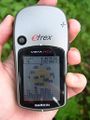
Coordinates reached
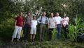
dawidi, Tomcat, Hans, Jochen, huirad, flomigulau, Nicole
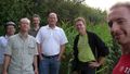
Hans, huirad, Tomcat, flomigulau, Der_Elch, dawidi
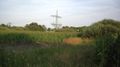
The hash is into that field, along the shrubbery to the right


dawidi earned the Drag-along achievement
|
Jochen, Nicole, huirad, flomigulau and Der_Elch (as well as dawidi, Tomcat and Hans) all earned the Bicycle geohash achievement
|
Jochen, Nicole, Tomcat and Hans earned the Meet-up achievement
|
huirad, flomigulau and Der_Elch earned the Meet-up achievement
|