Difference between revisions of "2009-08-16 48 11"
imported>Dawidi (→Photos: more pics) |
m |
||
| (One intermediate revision by one other user not shown) | |||
| Line 6: | Line 6: | ||
| graticule_name=München, Germany | | graticule_name=München, Germany | ||
| graticule_link=München, Germany}} | | graticule_link=München, Germany}} | ||
| + | ==Participants== | ||
| + | *[[User:Tomcat|Tomcat]] | ||
| + | *Hans | ||
| + | *[[User:dawidi|dawidi]] | ||
| + | *Manfred | ||
| + | |||
== Expedition == | == Expedition == | ||
The hashpoint happened to be in Stausacker, south of the "Weltenburg Narrows" near Weltenburg. That was an excellent location for an all day sunday-bicycle trip. dawidi, Hans, Manfred and Tomcat rode to Kelheim, where they visited the famous "Hall of Liberation" [http://en.wikipedia.org/wiki/Befreiungshalle], took some pictures and found a geocache before they cycled on to Stausacker where the hashpoint turned out to be just 3m behind a fence of a private property. Also here the usual pictures were taken before we took the ferry from Stausacker to Weltenburg and had lunch at the famous Weltenburg Abbey [http://en.wikipedia.org/wiki/Weltenburg_Abbey]. After that we walked on the hill behind the abbey and visited some more or less interesting archaeological sites before we passed the "Weltenburg Narrows" [http://de.wikipedia.org/wiki/Donaudurchbruch_bei_Weltenburg] with our bikes on a tiny boat and returned to Regensburg. The ride back was interrupted by the search for another geocache and a break in Bad Abbach where we had some coffee and icecream. | The hashpoint happened to be in Stausacker, south of the "Weltenburg Narrows" near Weltenburg. That was an excellent location for an all day sunday-bicycle trip. dawidi, Hans, Manfred and Tomcat rode to Kelheim, where they visited the famous "Hall of Liberation" [http://en.wikipedia.org/wiki/Befreiungshalle], took some pictures and found a geocache before they cycled on to Stausacker where the hashpoint turned out to be just 3m behind a fence of a private property. Also here the usual pictures were taken before we took the ferry from Stausacker to Weltenburg and had lunch at the famous Weltenburg Abbey [http://en.wikipedia.org/wiki/Weltenburg_Abbey]. After that we walked on the hill behind the abbey and visited some more or less interesting archaeological sites before we passed the "Weltenburg Narrows" [http://de.wikipedia.org/wiki/Donaudurchbruch_bei_Weltenburg] with our bikes on a tiny boat and returned to Regensburg. The ride back was interrupted by the search for another geocache and a break in Bad Abbach where we had some coffee and icecream. | ||
| Line 29: | Line 35: | ||
[[Category:Expeditions with photos]] | [[Category:Expeditions with photos]] | ||
[[Category:Coordinates reached]] | [[Category:Coordinates reached]] | ||
| + | {{location|DE|BY|KEH}} | ||
Latest revision as of 16:00, 19 March 2022
| Sun 16 Aug 2009 in München, Germany: 48.8929070, 11.8161114 geohashing.info google osm bing/os kml crox |
Participants
Expedition
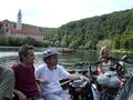
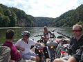
The hashpoint happened to be in Stausacker, south of the "Weltenburg Narrows" near Weltenburg. That was an excellent location for an all day sunday-bicycle trip. dawidi, Hans, Manfred and Tomcat rode to Kelheim, where they visited the famous "Hall of Liberation" [1], took some pictures and found a geocache before they cycled on to Stausacker where the hashpoint turned out to be just 3m behind a fence of a private property. Also here the usual pictures were taken before we took the ferry from Stausacker to Weltenburg and had lunch at the famous Weltenburg Abbey [2]. After that we walked on the hill behind the abbey and visited some more or less interesting archaeological sites before we passed the "Weltenburg Narrows" [3] with our bikes on a tiny boat and returned to Regensburg. The ride back was interrupted by the search for another geocache and a break in Bad Abbach where we had some coffee and icecream.
Photos

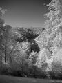
View into the Narrows from near the Hall of Liberation.
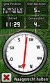
coordinates reached
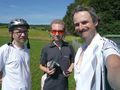
At the hashpoint.
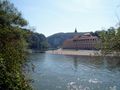
Weltenburg Abbey


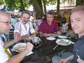
Lunch in the Abbey's beer garden
Heading into the Weltenburg Narrows on a small boat.
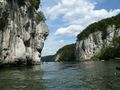
In the Narrows
After exiting the Narrows


