Difference between revisions of "2009-08-23 -37 146"
imported>Felix Dance |
imported>Felix Dance m |
||
| Line 24: | Line 24: | ||
"Oh, well that's alright then", she replied. | "Oh, well that's alright then", she replied. | ||
| − | That comment suddenly changed my whole day - I had to climb Mount Baw Baw... ( | + | That comment suddenly changed my whole day - I had to climb Mount Baw Baw. |
| + | |||
| + | After riding through extremely picturesque farmscapes and rolling hills (I took the long scenic route to Noogee), I came to the road's closest approach - 40kms north of the station. Here I hoisted my bike over a barbed wire fence and wandered up a steep tree-covered hill following the directions on my GPS. | ||
| + | |||
| + | Soon I came out into a green paddock above a small dam, so I stood in the correct spot, took some photos and rejoined my bike for what I'd by now decided to be a much longer trip. It was just after 1pm. | ||
| + | |||
| + | The 50 km ride up was much more undulating than I'd expected, with frequent up and down hills - and this was even before I'd gotten to the beginning of the Mount Baw Baw climb proper. I'd decided that I had to get to the top by 5pm in order to descend before dark fell, so I was riding as fast as I could. | ||
| + | |||
| + | Finally, I came to the base of the 6km steep climb at 3:30pm - plenty of time. Unfortunately, the climb was so steep that it took me 1.5 hours to get up it, pulling on my handlebars to get leverage on my pedals - despite having a specially low-geared bike I'd got for the Alpine Classic. As I got to the top (with two stops for dark chocolate and musk sticks) the wind picked up (a head wind) and I started seeing snow by the side of the road. | ||
| + | |||
| + | ... (More details to follow shortly). | ||
<gallery perrow="4"> | <gallery perrow="4"> | ||
| Line 62: | Line 72: | ||
[[Category:Expeditions]] | [[Category:Expeditions]] | ||
| − | [[Category:Coordinates | + | [[Category:Coordinates reached]] |
Revision as of 01:21, 24 August 2009
| Sun 23 Aug 2009 in -37,146: -37.9003524, 146.0261624 geohashing.info google osm bing/os kml crox |
The Place
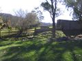
On a farm just off the road to Mount Baw Baw, Noogee, Victoria.
Expedition
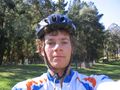
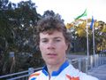
Felix Dance
When I looked at the coordinates for Sunday's geohash I saw that it was in Brighton East - quite close to my Port Melbourne home. Little did I realise what a massive day this would turn out to be.
No sooner did I send out an email to all the geohashes I knew about saying I'd be there at 2pm that I noticed that the geohash point for the unhashed graticule to the east was also accessible - and, as it covers most of Victoria's southern alps, this hardly ever happens. And that was it - I knew I had to get both of them.
I got up in time for 8:30am train to Warragul, carrying two sci-fi books, one hard cover, because I was about to finish the first, and a lot of food, but no front light. This was a mistake.
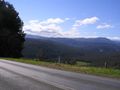
The ride to the hashpoint was extremely scenic, with a beautiful sunny day and very verdant vegetation. On the way I stopped at a milk bar in Neerim South where the lady asked if I was going up to the top of Mount Baw Baw.
"No, just to Noogee", I said. "Oh, well that's alright then", she replied.
That comment suddenly changed my whole day - I had to climb Mount Baw Baw.
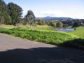
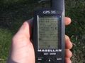
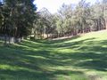
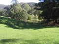
After riding through extremely picturesque farmscapes and rolling hills (I took the long scenic route to Noogee), I came to the road's closest approach - 40kms north of the station. Here I hoisted my bike over a barbed wire fence and wandered up a steep tree-covered hill following the directions on my GPS.
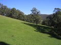
Soon I came out into a green paddock above a small dam, so I stood in the correct spot, took some photos and rejoined my bike for what I'd by now decided to be a much longer trip. It was just after 1pm.
The 50 km ride up was much more undulating than I'd expected, with frequent up and down hills - and this was even before I'd gotten to the beginning of the Mount Baw Baw climb proper. I'd decided that I had to get to the top by 5pm in order to descend before dark fell, so I was riding as fast as I could.
Finally, I came to the base of the 6km steep climb at 3:30pm - plenty of time. Unfortunately, the climb was so steep that it took me 1.5 hours to get up it, pulling on my handlebars to get leverage on my pedals - despite having a specially low-geared bike I'd got for the Alpine Classic. As I got to the top (with two stops for dark chocolate and musk sticks) the wind picked up (a head wind) and I started seeing snow by the side of the road.
... (More details to follow shortly).
Road to Geohash
Road to Noogee
GPS at Geohash Point
Geohash Surrounds South
Geohash Surrounds North
Geohash Surrounds East
Geohash Surrounds West
Felix at Geohash
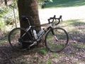
Bike Near Geohash
Felix at Mount Baw Baw
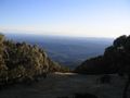
View From Mount Baw Baw


Felix Dance earned the Multihash Achievement
|