Difference between revisions of "2009-08-28 45 -122"
imported>Jiml m (Update location) |
m |
||
| (4 intermediate revisions by 2 users not shown) | |||
| Line 7: | Line 7: | ||
== Location == | == Location == | ||
| − | Beaverton, Oregon, on a side street: near Walker Road, on SW 122nd. | + | Beaverton, Oregon, on a side street: near Walker Road, on SW 122nd road. Close |
| − | + | to the road, though. | |
| − | |||
| Line 16: | Line 15: | ||
== Plans == | == Plans == | ||
| − | I' | + | I printed out the Google Maps page, but I knew the area, and had geohashed there |
| + | before, so it wasn't really necessary. Programming the GPS, however, was necessary. | ||
| − | + | == Expedition == | |
| + | I finished up some tasks at work, a little later than I wanted, as I needed to finish | ||
| + | some additional things for home before I left. | ||
| − | + | I went off towards the hashpoint, stopping to visit with an ATM on the way. However, I had | |
| + | to dodge around a bit, as there is a 3 day airshow going on at our local airport, so there | ||
| + | is a fair bit of traffic. (Folks heading to tomorrow's hashpoint in North Plains, Oregon, | ||
| + | should be careful of Airshow traffic! And, as it turns out, the LPGA tournament at the nearby golf course.) | ||
| + | On my way there, I glanced at the GPS and got to watch it tick down the miles. Soon | ||
| + | I hit Cedar Hills Blvd, and headed towards side streets. Almost as soon as I turned | ||
| + | onto 122nd, the GPS reported the hashpoint off to my left, so I parked, and proceeded | ||
| + | by foot. It got down to 20 feet at the end of the driveway, so I put my ambassador | ||
| + | smile on and headed up the driveway to ask for permission. I ran the doorbell, | ||
| + | but no one answered. (There were no cars in the driveway, in contrast to other houses | ||
| + | in the neighborhood.) | ||
| − | + | I was about to give up when I looked more closely at the GPS on my way back to the street. | |
| + | It reported only 12 feet to the hashpoint, but when I checked, the accuracy was floating | ||
| + | several feet higher, so I'm going to declare the haspoint reached. | ||
| + | I took a couple of pictures and went home. | ||
| − | == | + | == Achievement == |
| + | {{land geohash | latitude = 45 | longitude = -122 | date = 2009-08-28 | name = [[User:Jiml|Jim]] }} | ||
| − | + | ==Pictures== | |
| − | |||
| − | |||
| − | |||
| − | |||
<gallery perrow="3"> | <gallery perrow="3"> | ||
| − | + | Image:2009-08-28_45_-122-Neighborhood.jpg | Middling picture of the hashpoint's neighborhood | |
| + | Image:2009-08-28_45_-122-House.jpg |Poor picture of the hashpoint | ||
</gallery> | </gallery> | ||
| − | + | [[Category:Coordinates reached]][[Category:Expeditions with photos]][[Category:Expeditions]] | |
| − | + | {{location|US|OR|WI}} | |
| − | |||
| − | [[Category: | ||
| − | |||
| − | |||
| − | |||
| − | |||
| − | |||
| − | [[Category:Expeditions with photos]] | ||
| − | [[Category:Expeditions | ||
| − | |||
| − | |||
| − | |||
| − | |||
| − | |||
| − | |||
| − | |||
| − | |||
| − | |||
| − | |||
| − | |||
| − | |||
| − | |||
| − | |||
| − | |||
| − | |||
Latest revision as of 17:52, 19 April 2021
| Fri 28 Aug 2009 in 45,-122: 45.4996837, -122.8026864 geohashing.info google osm bing/os kml crox |
Location
Beaverton, Oregon, on a side street: near Walker Road, on SW 122nd road. Close to the road, though.
Participants
Plans
I printed out the Google Maps page, but I knew the area, and had geohashed there before, so it wasn't really necessary. Programming the GPS, however, was necessary.
Expedition
I finished up some tasks at work, a little later than I wanted, as I needed to finish some additional things for home before I left.
I went off towards the hashpoint, stopping to visit with an ATM on the way. However, I had to dodge around a bit, as there is a 3 day airshow going on at our local airport, so there is a fair bit of traffic. (Folks heading to tomorrow's hashpoint in North Plains, Oregon, should be careful of Airshow traffic! And, as it turns out, the LPGA tournament at the nearby golf course.)
On my way there, I glanced at the GPS and got to watch it tick down the miles. Soon I hit Cedar Hills Blvd, and headed towards side streets. Almost as soon as I turned onto 122nd, the GPS reported the hashpoint off to my left, so I parked, and proceeded by foot. It got down to 20 feet at the end of the driveway, so I put my ambassador smile on and headed up the driveway to ask for permission. I ran the doorbell, but no one answered. (There were no cars in the driveway, in contrast to other houses in the neighborhood.)
I was about to give up when I looked more closely at the GPS on my way back to the street. It reported only 12 feet to the hashpoint, but when I checked, the accuracy was floating several feet higher, so I'm going to declare the haspoint reached.
I took a couple of pictures and went home.
Achievement
Jim earned the Land geohash achievement
|
Pictures
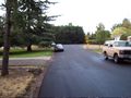
Middling picture of the hashpoint's neighborhood
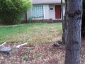
Poor picture of the hashpoint

