Difference between revisions of "2009-09-02 52 13"
imported>Davidc |
imported>FippeBot m (Location) |
||
| (19 intermediate revisions by 13 users not shown) | |||
| Line 5: | Line 5: | ||
}} | }} | ||
| − | |||
__NOTOC__ | __NOTOC__ | ||
== Location == | == Location == | ||
| − | + | In a field near Löwenberg in Brandenburg. | |
== Participants == | == Participants == | ||
| Line 21: | Line 20: | ||
== Expedition == | == Expedition == | ||
| + | After the success of the last few Brandenburg hashes, and having enjoyed seeing the countryside around Berlin, I set off for this hash in Löwenberger Land to the far northwest of the graticule. | ||
| − | + | I took the 13:49 from Gesundbrunnen, which kindly ran on schedule. Half an hour later I was in Löwenberg ready for the 3km cycle to the hash (or so I thought). I had two options for the return train: one leaving 20 minutes later and the other leaving 80 minutes later. | |
| + | Upon reaching the field however, a number of obstacles presented themselves. First, a 50m wide strip of dense wheat planted along the south side necessitated a lengthy detour through the rough to the far end of the deceptively large field and back through ploughed land. Second, the hash was further into the field than I thought, and landed in a large corn field which had to be negotiated. These obstacles overcome, rabbitfox and I reached the hash, observing many deer in the forest along the way. | ||
| + | |||
| + | Alas we had missed both trains back. Fortunately on this occasion, bahn.de was right and the local timetable display was wrong, and another train arrived an hour later. In the meantime we enjoyed a highly colourful Hamburger schnitzel. | ||
| + | |||
| + | Here is a corrected map to aid future visitors in avoiding [[Raptor|raptors]]. | ||
| + | |||
| + | [[Image:2009-09-02_52_13_updated_map.png]] | ||
== Photos == | == Photos == | ||
| − | |||
| − | |||
| − | |||
| − | |||
| − | |||
<gallery perrow="3"> | <gallery perrow="3"> | ||
| + | Image:2009-09-02_52_13_IMG_0257.JPG | On the way from Gesundbrunnen. | ||
| + | Image:2009-09-02_52_13_IMG_0262.JPG | Raptor (deer) forest by hash field. | ||
| + | Image:2009-09-02_52_13_IMG_0263.JPG | There were dozens of these along the field in varied states of repair. | ||
| + | Image:2009-09-02_52_13_IMG_0264.JPG | I eventually concluded they were for bird or deer watching. | ||
| + | Image:2009-09-02_52_13_IMG_0266.JPG | Raptors hiding in wheat pose Challenge #1. | ||
| + | Image:2009-09-02_52_13_IMG_0268.JPG | All the way to the end of the field and round. | ||
| + | Image:2009-09-02_52_13_IMG_0275.JPG | Raptors hiding in corn pose Challenge #2. | ||
| + | Image:2009-09-02_52_13_IMG_0281.JPG | View from the hash point. | ||
| + | Image:2009-09-02_52_13_IMG_0277.PNG | iPhone map proof. | ||
| + | Image:2009-09-02_52_13_IMG_0278.PNG | iPhon GPS proof. | ||
| + | Image:2009-09-02_52_13_IMG_0297.JPG | rabbitfox and I are now guerilla hashers. | ||
| + | Image:2009-09-02_52_13_IMG_0299.JPG | Weetabix mark an unavailable exit! | ||
| + | Image:2009-09-02_52_13_IMG_0300.JPG | Ostrich farm in Löwenberg! | ||
| + | Image:2009-09-02_52_13_IMG_0259.JPG | The crossing lowered for my train, and I was on the wrong side! | ||
| + | Image:2009-09-02_52_13_IMG_0303.JPG | But a colourful schnitzel helped pass the time. | ||
| + | </gallery> | ||
| + | |||
| + | == Videos == | ||
| + | |||
| + | [http://www.youtube.com/watch?v=12pxGNc9SOs The hashfield on YouTube] | ||
| − | + | == Ribbons == | |
| + | {{consecutive geohash | ||
| + | | count = 2 | ||
| + | | latitude = 52 | ||
| + | | longitude = 13 | ||
| + | | date = 2009-09-01 | ||
| + | | name = [[User:davidc|davidc]] | ||
| + | }} | ||
| − | |||
| − | |||
| − | |||
[[Category:Expeditions]] | [[Category:Expeditions]] | ||
| − | |||
[[Category:Expeditions with photos]] | [[Category:Expeditions with photos]] | ||
[[Category:Expeditions with videos]] | [[Category:Expeditions with videos]] | ||
| − | |||
| − | |||
| − | |||
| − | |||
[[Category:Coordinates reached]] | [[Category:Coordinates reached]] | ||
| − | + | {{location|DE|BB|OHV}} | |
| − | |||
| − | |||
| − | |||
| − | |||
| − | |||
| − | |||
| − | |||
| − | |||
| − | |||
Latest revision as of 05:33, 8 August 2019
| Wed 2 Sep 2009 in 52,13: 52.9171659, 13.1950023 geohashing.info google osm bing/os kml crox |
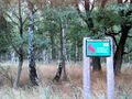
Location
In a field near Löwenberg in Brandenburg.
Participants
Plans
davidc taking 13:49 from Gesundbrunnen to Löwenberg (Mark).
Expedition
After the success of the last few Brandenburg hashes, and having enjoyed seeing the countryside around Berlin, I set off for this hash in Löwenberger Land to the far northwest of the graticule.
I took the 13:49 from Gesundbrunnen, which kindly ran on schedule. Half an hour later I was in Löwenberg ready for the 3km cycle to the hash (or so I thought). I had two options for the return train: one leaving 20 minutes later and the other leaving 80 minutes later.
Upon reaching the field however, a number of obstacles presented themselves. First, a 50m wide strip of dense wheat planted along the south side necessitated a lengthy detour through the rough to the far end of the deceptively large field and back through ploughed land. Second, the hash was further into the field than I thought, and landed in a large corn field which had to be negotiated. These obstacles overcome, rabbitfox and I reached the hash, observing many deer in the forest along the way.
Alas we had missed both trains back. Fortunately on this occasion, bahn.de was right and the local timetable display was wrong, and another train arrived an hour later. In the meantime we enjoyed a highly colourful Hamburger schnitzel.
Here is a corrected map to aid future visitors in avoiding raptors.

Photos

On the way from Gesundbrunnen.
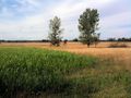
Raptor (deer) forest by hash field.
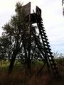
There were dozens of these along the field in varied states of repair.
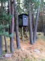
I eventually concluded they were for bird or deer watching.
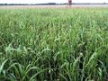
Raptors hiding in wheat pose Challenge #1.
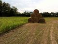
All the way to the end of the field and round.
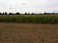
Raptors hiding in corn pose Challenge #2.
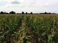
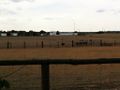
View from the hash point.
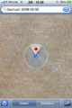
iPhone map proof.

iPhon GPS proof.

rabbitfox and I are now guerilla hashers.
Weetabix mark an unavailable exit!
Ostrich farm in Löwenberg!
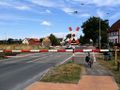
The crossing lowered for my train, and I was on the wrong side!

But a colourful schnitzel helped pass the time.


Videos
Ribbons
davidc earned the Consecutive geohash achievement
|