Difference between revisions of "2009-10-04 51 -1"
imported>JonRead (→Expedition) |
imported>FippeBot m (Location) |
||
| (7 intermediate revisions by 2 users not shown) | |||
| Line 23: | Line 23: | ||
== Expedition == | == Expedition == | ||
| + | |||
| + | [[User:JonRead|JonRead]]: After a big public transport failure for meeting up with [[User:Sermoa|Sermoa]], I nearly ran out of time to make it to this location. Fortunately, it turned out that my route to an appointment that evening happened to pass within a few hundred metres of it - so why not stop off on the way? | ||
| + | |||
| + | Waypoint in TomTom got me close, then the Android app got me closer. The point wasn't quite where it appeared to be in Google maps, and was behind a very thick hedge with no visible access. Due to being time-limited, I had to stop there - but was within a few metres by my estimate. | ||
| + | |||
| + | Point reached (and tweeted!), I headed off for a great photographer's barbeque for a fantastic and satisfying evening! :-) | ||
| + | |||
| + | == Gallery == | ||
<gallery perrow="4"> | <gallery perrow="4"> | ||
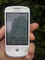
| − | Image:2009-10-04_51_-1_JonRead_1.jpg| | + | Image:2009-10-04_51_-1_JonRead_1.jpg|Geohash point as waypoint on right, current co-ordinates on left. |
| − | Image:2009-10-04_51_-1_JonRead_2.jpg| | + | Image:2009-10-04_51_-1_JonRead_2.jpg|It's up in that there hedge! |
| − | Image:2009-10-04_51_-1_JonRead_3.jpg| | + | Image:2009-10-04_51_-1_JonRead_3.jpg|Yeah - in there. |
| − | Image:2009-10-04_51_-1_JonRead_4.jpg| | + | Image:2009-10-04_51_-1_JonRead_4.jpg|View back from the point. |
| + | Image:2009-10-04_51_-1_JonRead_5.jpg|Twitpic sent from iPhone at the co-ordinates. | ||
</gallery> | </gallery> | ||
| − | |||
| − | |||
[[Category:Expeditions]] | [[Category:Expeditions]] | ||
| + | [[Category:Expeditions with photos]] | ||
[[Category:Coordinates reached]] | [[Category:Coordinates reached]] | ||
| + | {{location|GB|ENG|HAM}} | ||
Latest revision as of 06:10, 8 August 2019
| Sun 4 Oct 2009 in 51,-1: 51.0306115, -1.0173778 geohashing.info google osm bing/os kml crox |
Contents
Location
The Middle Of Nowhere, East Meon
Participants
Plans
Sermoa wanted to go, but the bus journey didn't work out and the train was going to take 5 hours to get 7 miles (i so need a scooter!) but JonRead has been, and at 16:07 i saw this on twitter:

I had look on the twitpic - it shows Jon at 51.03073, -1.01732 accurate to 4m so i say that is Coordinates reached! :) Hooray for the Swindon graticule! Even if i couldn't go, i'm very glad that somebody could!
Expedition
JonRead: After a big public transport failure for meeting up with Sermoa, I nearly ran out of time to make it to this location. Fortunately, it turned out that my route to an appointment that evening happened to pass within a few hundred metres of it - so why not stop off on the way?
Waypoint in TomTom got me close, then the Android app got me closer. The point wasn't quite where it appeared to be in Google maps, and was behind a very thick hedge with no visible access. Due to being time-limited, I had to stop there - but was within a few metres by my estimate.
Point reached (and tweeted!), I headed off for a great photographer's barbeque for a fantastic and satisfying evening! :-)
Gallery

Geohash point as waypoint on right, current co-ordinates on left.
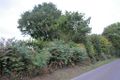
It's up in that there hedge!

Yeah - in there.

View back from the point.
Twitpic sent from iPhone at the co-ordinates.


