Difference between revisions of "2009-10-11 -37 144"
From Geohashing
imported>MykaDragonBlue (report thingy...) |
m (More specific location) |
||
| (5 intermediate revisions by 2 users not shown) | |||
| Line 1: | Line 1: | ||
| − | |||
<!-- If you did not specify these parameters in the template, please substitute appropriate things for IMAGE, LAT, LON, and DATE (YYYY-MM-DD format) --> | <!-- If you did not specify these parameters in the template, please substitute appropriate things for IMAGE, LAT, LON, and DATE (YYYY-MM-DD format) --> | ||
<!-- | <!-- | ||
| Line 10: | Line 9: | ||
}} | }} | ||
| − | |||
| − | |||
== Location == | == Location == | ||
| − | + | Just off the Northern Highway, near Tooborac | |
== Participants == | == Participants == | ||
| + | [[User:MykaDragonBlue|myka]] | ||
| − | |||
| − | |||
== Expedition == | == Expedition == | ||
| − | + | got there | |
| − | |||
| − | |||
| − | |||
== Photos == | == Photos == | ||
| − | |||
| − | |||
| − | |||
| − | |||
| − | |||
| − | |||
<gallery perrow="4"> | <gallery perrow="4"> | ||
| − | + | Image:2009-10-11_-37_144_mdb_001.jpg|in the car on the side of the highway with 35m to go. | |
| + | Image:2009-10-11_-37_144_mdb_002.jpg|proof. | ||
| + | Image:2009-10-11_-37_144_mdb_003.jpg|sunsetting. | ||
</gallery> | </gallery> | ||
| − | |||
| − | |||
| − | |||
| − | |||
| − | |||
| − | |||
[[Category:Expeditions]] | [[Category:Expeditions]] | ||
| − | |||
[[Category:Expeditions with photos]] | [[Category:Expeditions with photos]] | ||
| − | |||
| − | |||
| − | |||
| − | |||
| − | |||
[[Category:Coordinates reached]] | [[Category:Coordinates reached]] | ||
| − | + | {{location|AU|VIC|MC}} | |
| − | |||
| − | |||
| − | |||
| − | |||
| − | |||
| − | |||
| − | |||
| − | |||
| − | |||
Latest revision as of 11:52, 1 August 2020
| Sun 11 Oct 2009 in -37,144: -37.0091162, 144.7777181 geohashing.info google osm bing/os kml crox |
Contents
Location
Just off the Northern Highway, near Tooborac
Participants
Expedition
got there
Photos

in the car on the side of the highway with 35m to go.
proof.
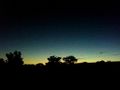
sunsetting.


