Difference between revisions of "2009-10-13 48 8"
imported>Fluxkompensator (→Participants: +fluxkompensator) |
imported>FippeBot m (Location) |
||
| (6 intermediate revisions by 4 users not shown) | |||
| Line 16: | Line 16: | ||
== Plans == | == Plans == | ||
| − | Since this hashpoint seemed easily accessible, both from the east from Rüppurr and from the north from Weiherfeld, I decided to try a tron geohash. I started planning two independent routes there and back on the city map and left my house at 15:00. | + | Koepfel: Since this hashpoint seemed easily accessible, both from the east from Rüppurr and from the north from Weiherfeld, I decided to try a tron geohash. I started planning two independent routes there and back on the city map and left my house at 15:00. |
| + | |||
| + | Fluxkompensator: Initially I wanted to visit the hash around 13:30 which did not work out. So later on I decided to go there in the evening. | ||
== Report == | == Report == | ||
| − | + | ||
| + | === Koepfel === | ||
| + | As planned, I left my home at 15:00 and biked through RIntheim to the tram depot at the Tullastraße, crossed the Durlacher Allee there and went on via Schlachthofstraße and Stuttgarter Straße, through a rather run-down neighbourhood. I then arrived in the Südstadt (south-city) quarter, at the Tivoliplatz, which is connected with the Kronenplatz (square near the university, where I started some of my expeditions) by the Rüppurrer Straße (Rüppurr Road), which I mostly use, when biking to the main station Today, I also had to bike past the main station and futher south, to Rüppurr, but since I was aiming for a tron Geohash, I had to avoid the inner city on the way there. | ||
| + | |||
| + | From the Tivoliplatz, I biked south under the railway line and then west along the backside of the main station adn turned left into the Ettlinger Allee, a rather large road leading South, through Ruppurr to Ettlingen. At the Südtangente, I stopped to photograph the large town signs, read the [[:Image:2009-10-13_48_8-town-sign.jpg|image description]] to find out more about them. | ||
| + | |||
| + | I biked along the Ettlinger Allee and the parallel Albtalbahn railway line, which one could also have used to reach the hashpoint, until Rüppurr Battstraße, where I turned right and after accidentally taking the wrong turn, resulting in a smaller detour (still tron-able), I crossed the Alb creek and found the Hashpoint on a grass field. I placed the marker and stayed until about 16:00. | ||
| + | |||
| + | Back home, I biked through Weiherfeld and Beiertheim, then via the main station. the Ettlinger Straße and through the inner city, which I avoided before, completing the tron geohash. | ||
Here's the Tracklog <span class="plainlinks">([http://geohash.koepfel.de/2009-10-13_48_8/2009-10-13_48_8.gpx .gpx], [http://geohash.koepfel.de/2009-10-13_48_8/2009-10-13_48_8.kmz .kmz], [http://maps.google.com/maps?q=http://geohash.koepfel.de/2009-10-13_48_8/2009-10-13_48_8.kmz in Google Maps])</span> of the complete expedition. The tracklog is off the road a couple of times, especially on the way home, when I rode between larger inner city houses. On the way there, the track even crosses itself once, when I had to stop abruptly at a traffic light. The GPS didn't realize I stopped and kept drawing the line halfway across the crossroads and then went back to where I was actually waiting. I can assure you, though, that I knew where I was going there and didn't cross my own path, as it's only like one kilometer from my house, so I should know the area,. | Here's the Tracklog <span class="plainlinks">([http://geohash.koepfel.de/2009-10-13_48_8/2009-10-13_48_8.gpx .gpx], [http://geohash.koepfel.de/2009-10-13_48_8/2009-10-13_48_8.kmz .kmz], [http://maps.google.com/maps?q=http://geohash.koepfel.de/2009-10-13_48_8/2009-10-13_48_8.kmz in Google Maps])</span> of the complete expedition. The tracklog is off the road a couple of times, especially on the way home, when I rode between larger inner city houses. On the way there, the track even crosses itself once, when I had to stop abruptly at a traffic light. The GPS didn't realize I stopped and kept drawing the line halfway across the crossroads and then went back to where I was actually waiting. I can assure you, though, that I knew where I was going there and didn't cross my own path, as it's only like one kilometer from my house, so I should know the area,. | ||
| Line 34: | Line 44: | ||
{{Tron | latitude = 48 | longitude = 8 | date = 2009-10-13 | name = Koepfel | tracklog = http://maps.google.com/maps?q=http://geohash.koepfel.de/2009-10-13_48_8/2009-10-13_48_8.kmz | possessive = his }} | {{Tron | latitude = 48 | longitude = 8 | date = 2009-10-13 | name = Koepfel | tracklog = http://maps.google.com/maps?q=http://geohash.koepfel.de/2009-10-13_48_8/2009-10-13_48_8.kmz | possessive = his }} | ||
| + | |||
| + | |||
| + | === Fluxkompensator === | ||
| + | |||
| + | I left my home at about 22:40 and cycled to the hashpoint which was 5 km in linear distance. On my way I passed the same "town sign" as Koepfel did. I reached the hashpoint after half an hour at 23:10. Believe it or not, I even found Koepfel's marker with only my bike's lamp, without having switched on the GPS device (which I did later on nevertheless). Before departing I had a look on his pictures and noticed that the hashpoint was directly besides a tractor track. I also took some pictures and (other than Koepfel) cycled back home the same way that I had come. | ||
| + | |||
| + | <gallery> | ||
| + | Image:2009-10-13_48_8_sign.jpg|Karlsruhe's oversized town sign at night. | ||
| + | Image:2009-10-13_48_8_hashpoint.jpg|Found Koepfel's marker. | ||
| + | Image:2009-10-13_48_8_delorean.jpg|My signature. | ||
| + | Image:2009-10-13_48_8_gps.jpg|Etrex GPS device at hash co-ordinates. | ||
| + | </gallery> | ||
[[Category:Expeditions with photos]] | [[Category:Expeditions with photos]] | ||
[[Category:Expeditions]] | [[Category:Expeditions]] | ||
[[Category:Coordinates reached]] | [[Category:Coordinates reached]] | ||
| + | {{location|DE|BW|KA|city=true}} | ||
Latest revision as of 06:19, 8 August 2019
| Tue 13 Oct 2009 in 48,8: 48.9677558, 8.3931876 geohashing.info google osm bing/os kml crox |
Location
In a field in Karlsruhe's suburb Rüppurr, population 10.000.
Participants
- Koepfel (afternoon)
- Fluxkompensator (late evening)
Plans
Koepfel: Since this hashpoint seemed easily accessible, both from the east from Rüppurr and from the north from Weiherfeld, I decided to try a tron geohash. I started planning two independent routes there and back on the city map and left my house at 15:00.
Fluxkompensator: Initially I wanted to visit the hash around 13:30 which did not work out. So later on I decided to go there in the evening.
Report
Koepfel
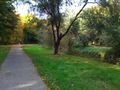
As planned, I left my home at 15:00 and biked through RIntheim to the tram depot at the Tullastraße, crossed the Durlacher Allee there and went on via Schlachthofstraße and Stuttgarter Straße, through a rather run-down neighbourhood. I then arrived in the Südstadt (south-city) quarter, at the Tivoliplatz, which is connected with the Kronenplatz (square near the university, where I started some of my expeditions) by the Rüppurrer Straße (Rüppurr Road), which I mostly use, when biking to the main station Today, I also had to bike past the main station and futher south, to Rüppurr, but since I was aiming for a tron Geohash, I had to avoid the inner city on the way there.
From the Tivoliplatz, I biked south under the railway line and then west along the backside of the main station adn turned left into the Ettlinger Allee, a rather large road leading South, through Ruppurr to Ettlingen. At the Südtangente, I stopped to photograph the large town signs, read the image description to find out more about them.
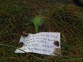
I biked along the Ettlinger Allee and the parallel Albtalbahn railway line, which one could also have used to reach the hashpoint, until Rüppurr Battstraße, where I turned right and after accidentally taking the wrong turn, resulting in a smaller detour (still tron-able), I crossed the Alb creek and found the Hashpoint on a grass field. I placed the marker and stayed until about 16:00.
Back home, I biked through Weiherfeld and Beiertheim, then via the main station. the Ettlinger Straße and through the inner city, which I avoided before, completing the tron geohash.
Here's the Tracklog (.gpx, .kmz, in Google Maps) of the complete expedition. The tracklog is off the road a couple of times, especially on the way home, when I rode between larger inner city houses. On the way there, the track even crosses itself once, when I had to stop abruptly at a traffic light. The GPS didn't realize I stopped and kept drawing the line halfway across the crossroads and then went back to where I was actually waiting. I can assure you, though, that I knew where I was going there and didn't cross my own path, as it's only like one kilometer from my house, so I should know the area,.
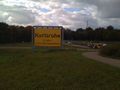
Karlsruhe's oversized town sign
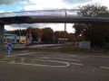
Rüppurr Battstraße
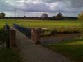
A few more meters...
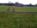
...reached.
Biking home


Koepfel earned the Tron achievement
|
Fluxkompensator
I left my home at about 22:40 and cycled to the hashpoint which was 5 km in linear distance. On my way I passed the same "town sign" as Koepfel did. I reached the hashpoint after half an hour at 23:10. Believe it or not, I even found Koepfel's marker with only my bike's lamp, without having switched on the GPS device (which I did later on nevertheless). Before departing I had a look on his pictures and noticed that the hashpoint was directly besides a tractor track. I also took some pictures and (other than Koepfel) cycled back home the same way that I had come.
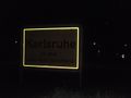
Karlsruhe's oversized town sign at night.
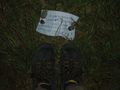
Found Koepfel's marker.
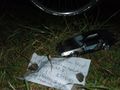
My signature.
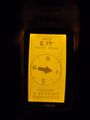
Etrex GPS device at hash co-ordinates.


