Difference between revisions of "2009-10-31 43 -79"
imported>Splitdipless (→Location) |
m (More specific location) |
||
| (3 intermediate revisions by 2 users not shown) | |||
| Line 10: | Line 10: | ||
<!-- edit as necessary --> | <!-- edit as necessary --> | ||
| − | |||
== Location == | == Location == | ||
| − | The point | + | Satellite imagery from Google maps suggested an undeveloped neighbourhood in the north area of Ajax. The point was on a narrow strip of grass between two driveways in a fully operational neighbourhood. |
| − | == | + | == Expedition == |
| − | + | === [[User:Splitdipless|Splitdipless]] === | |
| − | |||
| − | == | ||
| + | After looking to see that the point would be in an unopened subdivision, the thought of doing the hash at night on halloween seemed very scary. After stopping by the bank to get some spending money, I pulled out my GPS and camera and started looking for the peice of paper with my crude driving map. I couldn't find it. | ||
| − | + | Knowing that the point was somewhere in north Ajax or Pickering, I simply turned on the GPS and started driving, hoping that my memory would kick in. The GPS was able to direct me very well to within 800 m, but then my memory failed me as I began to navigate the twisting subdivision. Luckily, I was able to get my bearings in record time when one street name sounded familiar and I encountered an easy to recall navigation aide: a roundabout. They're pretty unusual to find around here. | |
| + | Arriving near the point, I realized that the subdivision was actually mostly done and a lot of families had moved in. Indeed, there where many targets... er, I mean kids, out to collect candy in costume. | ||
| − | + | The point I thought would be in a person's driveway on the north side of the street, but ended up being between two driveways on a narrow strip of grass on the south side. I lamented at the size of the grass, as it demonstrates how little space there is between houses in newer subdivisions these days. I could never live in a new house simply because of how close the houses are to each other. | |
| + | I found a unique artifact. It was a black piece of plastic, almost like a coffee mug, but lacking the handle. In honour of the occation, I named it 'the ghost of something useful.' I suddenly became aware of a group of trolls heading my way (could have also been kids, I guess) so I decided to leave in some haste. | ||
== Photos == | == Photos == | ||
| − | |||
| − | |||
| − | |||
| − | |||
| − | |||
<gallery perrow="4"> | <gallery perrow="4"> | ||
| − | + | Image:2009-10-31 43 -79 A.jpg | Ooohh. Spooky. | |
| + | Image:2009-10-31 43 -79 B.jpg | A depressing bit of lawn, with the ghost of something useful. | ||
| + | Image:2009-10-31 43 -79 C.jpg | Zero'd in on paranormal activity. | ||
</gallery> | </gallery> | ||
| − | |||
| − | |||
| − | |||
| − | |||
| − | |||
| − | |||
| − | |||
[[Category:Expeditions]] | [[Category:Expeditions]] | ||
| − | |||
[[Category:Expeditions with photos]] | [[Category:Expeditions with photos]] | ||
| − | |||
| − | |||
| − | |||
| − | |||
[[Category:Coordinates reached]] | [[Category:Coordinates reached]] | ||
| − | + | {{location|CA|ON|DR}} | |
| − | |||
| − | |||
| − | |||
| − | |||
| − | |||
| − | |||
| − | |||
| − | |||
| − | |||
Latest revision as of 23:13, 9 August 2020
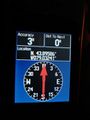
| Sat 31 Oct 2009 in 43,-79: 43.8958688, -79.0324121 geohashing.info google osm bing/os kml crox |
Contents
Location
Satellite imagery from Google maps suggested an undeveloped neighbourhood in the north area of Ajax. The point was on a narrow strip of grass between two driveways in a fully operational neighbourhood.
Expedition
Splitdipless
After looking to see that the point would be in an unopened subdivision, the thought of doing the hash at night on halloween seemed very scary. After stopping by the bank to get some spending money, I pulled out my GPS and camera and started looking for the peice of paper with my crude driving map. I couldn't find it.
Knowing that the point was somewhere in north Ajax or Pickering, I simply turned on the GPS and started driving, hoping that my memory would kick in. The GPS was able to direct me very well to within 800 m, but then my memory failed me as I began to navigate the twisting subdivision. Luckily, I was able to get my bearings in record time when one street name sounded familiar and I encountered an easy to recall navigation aide: a roundabout. They're pretty unusual to find around here.
Arriving near the point, I realized that the subdivision was actually mostly done and a lot of families had moved in. Indeed, there where many targets... er, I mean kids, out to collect candy in costume.
The point I thought would be in a person's driveway on the north side of the street, but ended up being between two driveways on a narrow strip of grass on the south side. I lamented at the size of the grass, as it demonstrates how little space there is between houses in newer subdivisions these days. I could never live in a new house simply because of how close the houses are to each other.
I found a unique artifact. It was a black piece of plastic, almost like a coffee mug, but lacking the handle. In honour of the occation, I named it 'the ghost of something useful.' I suddenly became aware of a group of trolls heading my way (could have also been kids, I guess) so I decided to leave in some haste.
Photos

Ooohh. Spooky.
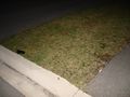
A depressing bit of lawn, with the ghost of something useful.
Zero'd in on paranormal activity.


