Difference between revisions of "2009-11-04 34 -84"
(New page: {{meetup graticule | map=<map lat="34" lon="-84" date="2009-11-04" /> | lat=34 | lon=-84 | date=2009-11-04 | graticule_name=Roswell | graticule_link=Roswell, Georgia }} == Graticule == ...) |
m (Replacing http://wiki.xkcd.com/geohashing/Roswell%2C_Georgia with Roswell, Georgia) |
||
| (7 intermediate revisions by 3 users not shown) | |||
| Line 10: | Line 10: | ||
== Graticule == | == Graticule == | ||
| − | [ | + | [[Roswell, Georgia|Roswell]] |
== About == | == About == | ||
| Line 18: | Line 18: | ||
* [[User:NWoodruff|NWoodruff]] | * [[User:NWoodruff|NWoodruff]] | ||
| + | |||
| + | I really need to invest in a flash light if I am going to Geohash now after dark. I pulled into the parking lot and drove my truck so it pointed at the back of the building and put the high beams of the headlights on. | ||
| + | |||
| + | It was still a 300 feet walk to where the spot was and from 300 feet a way, my head lights on the truck were not doing all that much good. There is a patch of grass that extends about 50 feet from the building but geohash spot was probably more like 80 feet from the building. That meant a 30 foot walk into the trees. I couldn't see a thing as I was walking into the tall grass and trees. For some reason the mostly full moon was not up at this time providing light. | ||
| + | |||
| + | I inched my way into the tree line and kept an eye on my eTrex. After running face first into several small pine trees slightly taller than me, I found the hash spot with 1.25 feet to go. I took a few pictures and noticed how the flash of the camera lite the area up. I tried to take several pictures using the flash but almost none of them turned out. | ||
| + | |||
| + | I carefully stepped my way back out of the tree line to the mowed grass path behind the building. I then made my way back to my truck and drove home to Norcross. | ||
| + | |||
| + | 15 in a row. Here's hoping that I make it to at least 18. | ||
==Expeditions== | ==Expeditions== | ||
| Line 25: | Line 35: | ||
== Gallery == | == Gallery == | ||
<gallery caption="Photo Gallery" widths="200px" heights="200px" perrow="3"> | <gallery caption="Photo Gallery" widths="200px" heights="200px" perrow="3"> | ||
| − | Image:200921104_34_-84NW01.JPG| | + | Image:200921104_34_-84NW01.JPG| 1.25 feet to go. Close enough. |
| + | Image:200921104_34_-84NW02.JPG| Time of the meetup. | ||
| + | Image:200921104_34_-84NW03.JPG| A picture of the area standing on the hash spot. | ||
| + | Image:200921104_34_-84NW04.JPG| Another picture of the area using the flash of the camera. | ||
| + | Image:200921104_34_-84NW05.JPG| Looking towards the building standing on the hash spot. | ||
</gallery> | </gallery> | ||
| Line 31: | Line 45: | ||
{{Land geohash | latitude = 34 | longitude = -84| date = 2009-11-04| name = NWoodruff}} | {{Land geohash | latitude = 34 | longitude = -84| date = 2009-11-04| name = NWoodruff}} | ||
| + | {{consecutive geohash | count = 15 | latitude = 33 | longitude = -84 | date = 2009-10-21 | name = NWoodruff }} | ||
| + | |||
| Line 36: | Line 52: | ||
[[Category:Coordinates reached]] | [[Category:Coordinates reached]] | ||
[[Category:Expeditions with photos]] | [[Category:Expeditions with photos]] | ||
| + | {{location|US|GA|GW}} | ||
Latest revision as of 12:24, 19 February 2020
| Wed 4 Nov 2009 in Roswell: 34.0272437, -84.1049686 geohashing.info google osm bing/os kml crox |
Graticule
About
In the back lot of a business in Duluth Georgia.
People
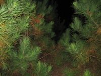
I really need to invest in a flash light if I am going to Geohash now after dark. I pulled into the parking lot and drove my truck so it pointed at the back of the building and put the high beams of the headlights on.
It was still a 300 feet walk to where the spot was and from 300 feet a way, my head lights on the truck were not doing all that much good. There is a patch of grass that extends about 50 feet from the building but geohash spot was probably more like 80 feet from the building. That meant a 30 foot walk into the trees. I couldn't see a thing as I was walking into the tall grass and trees. For some reason the mostly full moon was not up at this time providing light.
I inched my way into the tree line and kept an eye on my eTrex. After running face first into several small pine trees slightly taller than me, I found the hash spot with 1.25 feet to go. I took a few pictures and noticed how the flash of the camera lite the area up. I tried to take several pictures using the flash but almost none of them turned out.
I carefully stepped my way back out of the tree line to the mowed grass path behind the building. I then made my way back to my truck and drove home to Norcross.
15 in a row. Here's hoping that I make it to at least 18.
Expeditions
Gallery
- Photo Gallery
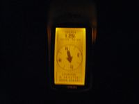
1.25 feet to go. Close enough.
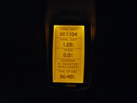
Time of the meetup.
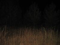
A picture of the area standing on the hash spot.
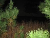
Another picture of the area using the flash of the camera.
Looking towards the building standing on the hash spot.


Achievements
NWoodruff earned the Land geohash achievement
|
NWoodruff earned the Consecutive geohash achievement
|