Difference between revisions of "2009-11-08 48 8"
imported>Thepiguy (Begin merciles editing!) |
imported>FippeBot m (Location) |
||
| (3 intermediate revisions by 2 users not shown) | |||
| Line 20: | Line 20: | ||
They arrived in Stammheim and with the help of Ekorren's wonderful map they began following the trail that would lead them right to the Geohash. At first is took along a few small roads that lead out of town. Next it lead them along and even smaller road that took them to the top of the hill. Next was the forest road that was covered in nothing but rocks, mud, and leaves (although it was apparently a jogging path). And finally a short walk next to a field only a few meters from the coordinates. | They arrived in Stammheim and with the help of Ekorren's wonderful map they began following the trail that would lead them right to the Geohash. At first is took along a few small roads that lead out of town. Next it lead them along and even smaller road that took them to the top of the hill. Next was the forest road that was covered in nothing but rocks, mud, and leaves (although it was apparently a jogging path). And finally a short walk next to a field only a few meters from the coordinates. | ||
| − | After the usual celebrations they continued onward to the train station of | + | After the usual celebrations they continued onward to the train station of Bad Teinach. The station was only one kilometer away, as the crow flies. The elevation difference on this one kilometer however, was over 200 meters. Before beginning the descent, they stopped to visit what the map declared to be the ruins of a castle, but what turned out to be the ruins of a moat. The trail they were following turned out to be very interesting! It featured cliffs, sheer drops, hidden rocks, stairs and multiple ladders. Never the less, the three Geohashers made it safely back to civilisation! (if Teinach station even qualifies as that) |
== Gallery == | == Gallery == | ||
<gallery> | <gallery> | ||
| + | Image:2009-11-08_48_8-tübingen.jpg|Tübingen in less than 15 minutes | ||
| + | Image:2009-11-08_48_8-bus.jpg|Bus dropped us off in Stammheim | ||
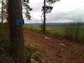
Image:2009-11-08_48_8_e_Gaeurandweg-Symbol.JPG|Follow the red <s>herring</s> hip | Image:2009-11-08_48_8_e_Gaeurandweg-Symbol.JPG|Follow the red <s>herring</s> hip | ||
Image:2009-11-08_48_8_e_Ortsausgangsschild_Stammheim.jpg|Leaving Stammheim. Would be 5 km to the station along the road. | Image:2009-11-08_48_8_e_Ortsausgangsschild_Stammheim.jpg|Leaving Stammheim. Would be 5 km to the station along the road. | ||
Image:2009-11-08_48_8_e_Stammheim_View_back.jpg|View back on Stammheim | Image:2009-11-08_48_8_e_Stammheim_View_back.jpg|View back on Stammheim | ||
| + | Image:2009-11-08_48_8-jogging.jpg|Yes, this is a jogging path | ||
Image:2009-11-08_48_8_feet.JPG|Walking along the forest trail. | Image:2009-11-08_48_8_feet.JPG|Walking along the forest trail. | ||
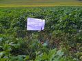
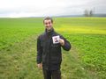
Image:2009-11-08_48_8_gps.JPG|Geohash confirmed! | Image:2009-11-08_48_8_gps.JPG|Geohash confirmed! | ||
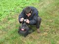
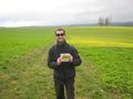
Image:2009-11-08_48_8_e_GPS.jpg|Double confirmation | Image:2009-11-08_48_8_e_GPS.jpg|Double confirmation | ||
| + | Image:2009-11-08_48_8-hashscots.jpg|They meet again... | ||
Image:2009-11-08_48_8_e_Koepfel_Marker.jpg|Shooting the marker | Image:2009-11-08_48_8_e_Koepfel_Marker.jpg|Shooting the marker | ||
Image:2009-11-08_48_8_e_Pi_Tripod.jpg|Preparing group photo... | Image:2009-11-08_48_8_e_Pi_Tripod.jpg|Preparing group photo... | ||
| Line 43: | Line 47: | ||
Image:2009-11-08_48_8_e_Radfahrer_verboten.jpg|This once read: Bicyclists forbidden. We would soon find out why: | Image:2009-11-08_48_8_e_Radfahrer_verboten.jpg|This once read: Bicyclists forbidden. We would soon find out why: | ||
Image:2009-11-08_48_8_e_Rocks.jpg|There were cliffs. | Image:2009-11-08_48_8_e_Rocks.jpg|There were cliffs. | ||
| + | Image:2009-11-08_48_8-path.jpg|Yes, we are still on a path. | ||
Image:2009-11-08_48_8_e_Ladder_1.jpg|Ladder to somewhere | Image:2009-11-08_48_8_e_Ladder_1.jpg|Ladder to somewhere | ||
| + | Image:2009-11-08_48_8-ladder.jpg|On one of the ladders | ||
Image:2009-11-08_48_8_e_Treeees.jpg|More treeeeees... | Image:2009-11-08_48_8_e_Treeees.jpg|More treeeeees... | ||
| + | Image:2009-11-08_48_8-valley.jpg|The Nagold Valley | ||
</gallery> | </gallery> | ||
| − | + | All of Koepfel's photos can be seen in [http://geohash.koepfel.de/2009-11-08_48_8/ this gallery]. | |
[[Category:Expeditions]] | [[Category:Expeditions]] | ||
[[Category:Coordinates reached]] | [[Category:Coordinates reached]] | ||
[[Category:Expeditions with photos]] | [[Category:Expeditions with photos]] | ||
| + | {{location|DE|BW|CW}} | ||
Latest revision as of 06:44, 8 August 2019
| Sun 8 Nov 2009 in 48,8: 48.6808936, 8.7485891 geohashing.info google osm bing/os kml crox |
Contents
Location
A field at the westernmost margin of the Oberes Gäu hills, between the villages of Stammheim and Holzbronn, which both are incorporated to Calw.
Participants
Expedition
thepiguy made it to Tübingen by 10:30 where Ekorren and (surprise!) Koepfel were waiting for him. Ekorren gave them both a very quick tour of his home town ("You can see everything famous from one spot anyway") and they boarded the first train to their destination.
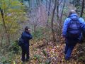
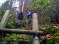
They arrived in Stammheim and with the help of Ekorren's wonderful map they began following the trail that would lead them right to the Geohash. At first is took along a few small roads that lead out of town. Next it lead them along and even smaller road that took them to the top of the hill. Next was the forest road that was covered in nothing but rocks, mud, and leaves (although it was apparently a jogging path). And finally a short walk next to a field only a few meters from the coordinates.
After the usual celebrations they continued onward to the train station of Bad Teinach. The station was only one kilometer away, as the crow flies. The elevation difference on this one kilometer however, was over 200 meters. Before beginning the descent, they stopped to visit what the map declared to be the ruins of a castle, but what turned out to be the ruins of a moat. The trail they were following turned out to be very interesting! It featured cliffs, sheer drops, hidden rocks, stairs and multiple ladders. Never the less, the three Geohashers made it safely back to civilisation! (if Teinach station even qualifies as that)
Gallery
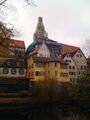
Tübingen in less than 15 minutes
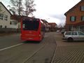
Bus dropped us off in Stammheim

Follow the red
herringhip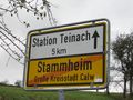
Leaving Stammheim. Would be 5 km to the station along the road.
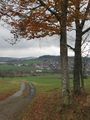
View back on Stammheim
Yes, this is a jogging path
Walking along the forest trail.
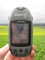
Geohash confirmed!
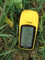
Double confirmation
They meet again...
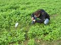
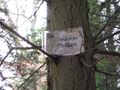
Shooting the marker
Preparing group photo...
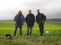
Geohashers unite!
thepiguy finds the final piece...
... and gets out the shades!
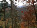
View from hash
View from hash
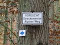
"Attention! Partly alpine way" - how bad can it get?
Ladder to nowhere

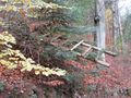
The moat kept us from conquering a castle that wasn't there anyway.
This once read: Bicyclists forbidden. We would soon find out why:
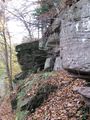
There were cliffs.
Yes, we are still on a path.
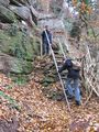
Ladder to somewhere
On one of the ladders
More treeeeees...
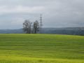
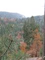
The Nagold Valley


All of Koepfel's photos can be seen in this gallery.