Difference between revisions of "2009-11-13 45 -122"
imported>Michael5000 (→Photos) |
imported>Michael5000 m (→Michael5000's Expedition) |
||
| Line 21: | Line 21: | ||
This hash point was a fifteen minute drive from work, so I made a lunch that I could stuff into the pockets of a winter coat. By a minute past noon, I was pulling away from the office and heading north towards the I-205 bridge. Fifteen minutes of driving got me to a field on the eastern fringe of The 'Couv. | This hash point was a fifteen minute drive from work, so I made a lunch that I could stuff into the pockets of a winter coat. By a minute past noon, I was pulling away from the office and heading north towards the I-205 bridge. Fifteen minutes of driving got me to a field on the eastern fringe of The 'Couv. | ||
| − | The site presented some surprises. Where Google satellite imagery showed a stand of trees between SE 192nd Avenue and the field, now there is a pair of large semi-gated apartment complexes. Each of these had an odd little guardhouse, but they were unmanned and nobody much was about on a cold, wet workday. I scrambled down a rip-rap slope to the field and made my way across a hummocky, not-quite-swampy pasture to | + | The site presented some surprises. Where Google satellite imagery showed a stand of trees between SE 192nd Avenue and the field, now there is a pair of large semi-gated apartment complexes. Each of these had an odd little guardhouse, but they were unmanned and nobody much was about on a cold, wet workday. I scrambled down a rip-rap slope to the field and made my way across a hummocky, not-quite-swampy pasture to where I thought was about halfway to the hash point. Checking the map and sattelite image, though, I realized that I was virtually standing on it -- the field isn't is big as it used to be, now that the apartments are there. |
I took a couple of pictures and headed back to the truck. On the way back to Oregon, I blasted hot air at my wet shoes and the hem of my slacks. I arrived back behind the desk with six minutes of lunch break to spare! | I took a couple of pictures and headed back to the truck. On the way back to Oregon, I blasted hot air at my wet shoes and the hem of my slacks. I arrived back behind the desk with six minutes of lunch break to spare! | ||
Revision as of 08:57, 14 November 2009
| Fri 13 Nov 2009 in 45,-122: 45.6064666, -122.4734952 geohashing.info google osm bing/os kml crox |
Location
In a field on the eastern fringe of Vancouver, Washington.
Participants
Expeditions
Michael5000's Expedition
This hash point was a fifteen minute drive from work, so I made a lunch that I could stuff into the pockets of a winter coat. By a minute past noon, I was pulling away from the office and heading north towards the I-205 bridge. Fifteen minutes of driving got me to a field on the eastern fringe of The 'Couv.
The site presented some surprises. Where Google satellite imagery showed a stand of trees between SE 192nd Avenue and the field, now there is a pair of large semi-gated apartment complexes. Each of these had an odd little guardhouse, but they were unmanned and nobody much was about on a cold, wet workday. I scrambled down a rip-rap slope to the field and made my way across a hummocky, not-quite-swampy pasture to where I thought was about halfway to the hash point. Checking the map and sattelite image, though, I realized that I was virtually standing on it -- the field isn't is big as it used to be, now that the apartments are there.
I took a couple of pictures and headed back to the truck. On the way back to Oregon, I blasted hot air at my wet shoes and the hem of my slacks. I arrived back behind the desk with six minutes of lunch break to spare!
Photos
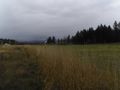
Looking northeast: lovely countryside.
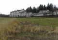
Looking southwest: brand-new apartment complex.

