Difference between revisions of "2009-11-14 60 16"
From Geohashing
imported>The ru m |
m (per Renaming Proposal) |
||
| (One intermediate revision by one other user not shown) | |||
| Line 9: | Line 9: | ||
| − | {{ | + | {{Graticule unlocked| latitude = 60 | longitude = 16 | date = 2009-11-14 | name = [[User:the ru|the ru]] | image = 2009-11-14_60_16_gps.jpg}} |
| Line 23: | Line 23: | ||
[[Category:Expeditions with photos]] | [[Category:Expeditions with photos]] | ||
[[Category:Coordinates reached]] | [[Category:Coordinates reached]] | ||
| + | {{location|SE|U}} | ||
Latest revision as of 06:20, 20 March 2024
| Sat 14 Nov 2009 in 60,16: 60.0066557, 16.4024189 geohashing.info google osm bing/os kml crox |
the ru was there. From Västerås I drove road 56 to Sala, then road 70 towards Avesta. There was some road construction going on near the hashpoint. I made it just in time for the meetup, alas did not see anyone else out there.
the ru earned the Graticule Unlocked Achievement
|
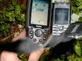
GPS @ the hashpoint
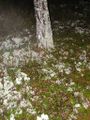
The hashpoint. The white is lichen, not snow.
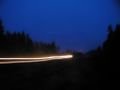
Playing around with long shutter speeds on the way back to the car. I didn't have any tripod. Seeing this picture made me realise how many dead pixels my camera has developed.